• 文献检索
  • 文档翻译
  • 深度研究
  • 学术资讯
  • Suppr Zotero 插件Zotero 插件
  • 邀请有礼
  • 套餐&价格
  • 历史记录
应用&插件
Suppr Zotero 插件Zotero 插件浏览器插件Mac 客户端Windows 客户端微信小程序
定价
高级版会员购买积分包购买API积分包
服务
文献检索文档翻译深度研究API 文档MCP 服务
关于我们
关于 Suppr公司介绍联系我们用户协议隐私条款
关注我们

Suppr 超能文献

核心技术专利:CN118964589B侵权必究
粤ICP备2023148730 号-1Suppr @ 2026

文献检索

告别复杂PubMed语法,用中文像聊天一样搜索,搜遍4000万医学文献。AI智能推荐,让科研检索更轻松。

立即免费搜索

文件翻译

保留排版,准确专业,支持PDF/Word/PPT等文件格式,支持 12+语言互译。

免费翻译文档

深度研究

AI帮你快速写综述,25分钟生成高质量综述,智能提取关键信息,辅助科研写作。

立即免费体验

一种用于识别“食物荒漠”的线性镶嵌模型:以上海为例的案例研究

A linear tessellation model for the identification of "food desert": A case study of Shanghai, China.

作者信息

Wang Lu, He Yakun, Yu Zhonghai, Wang Hongrui, Ye Wenjuan, Li Xin, Liu Yingping, Zhang Junxiao

机构信息

Jinan Surveying and Mapping Research Institute, Jinan, China.

Chinese Aeronautical Establishment, Beijing, China.

出版信息

PLoS One. 2025 Jan 22;20(1):e0317003. doi: 10.1371/journal.pone.0317003. eCollection 2025.

DOI:10.1371/journal.pone.0317003
PMID:39841653
原文链接:https://pmc.ncbi.nlm.nih.gov/articles/PMC11753656/
Abstract

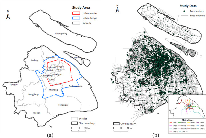
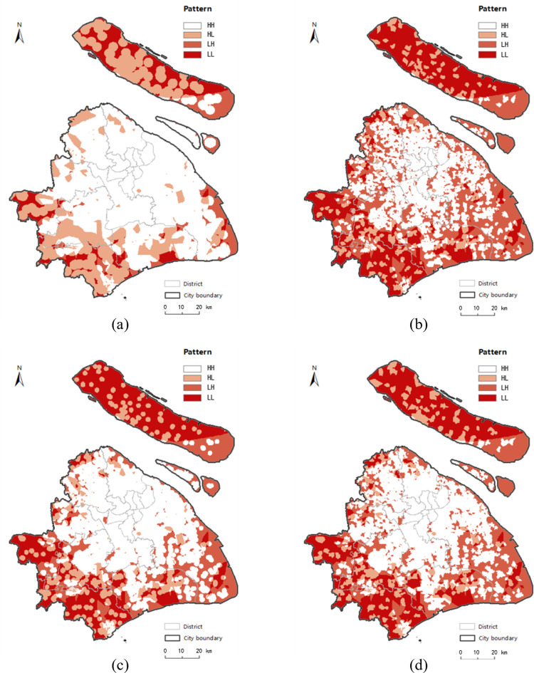
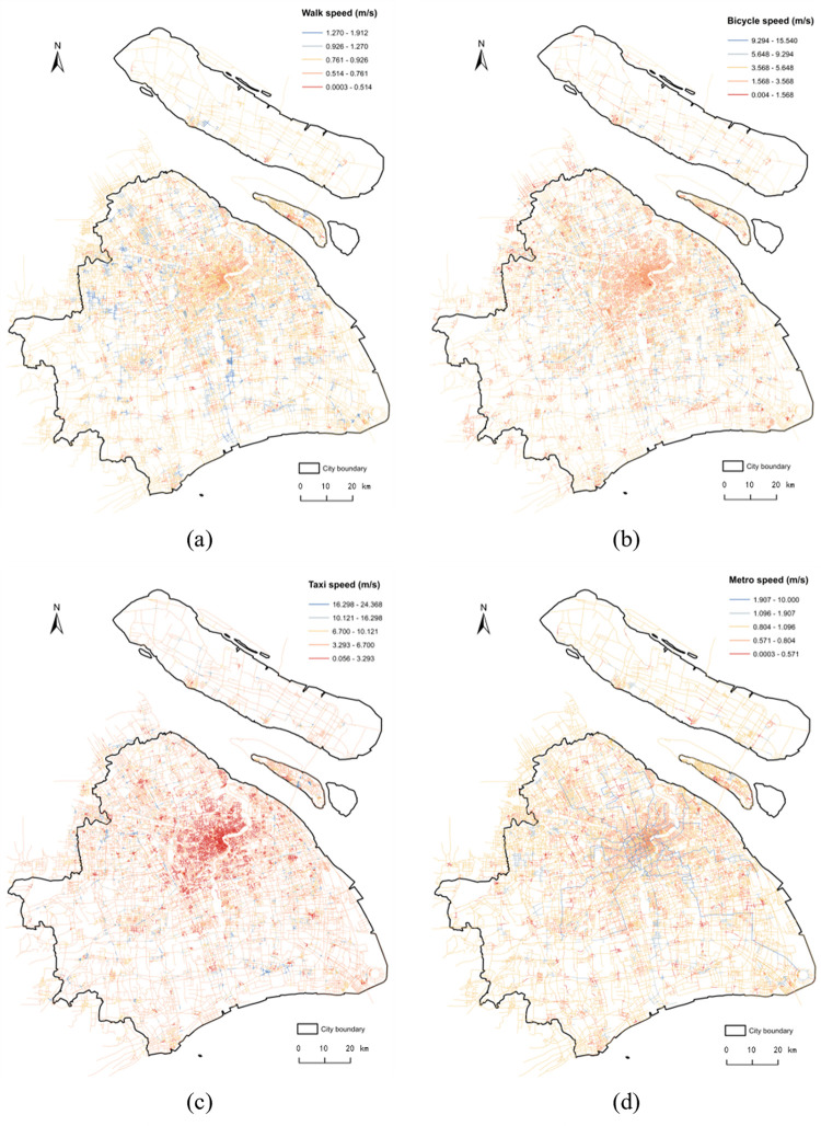
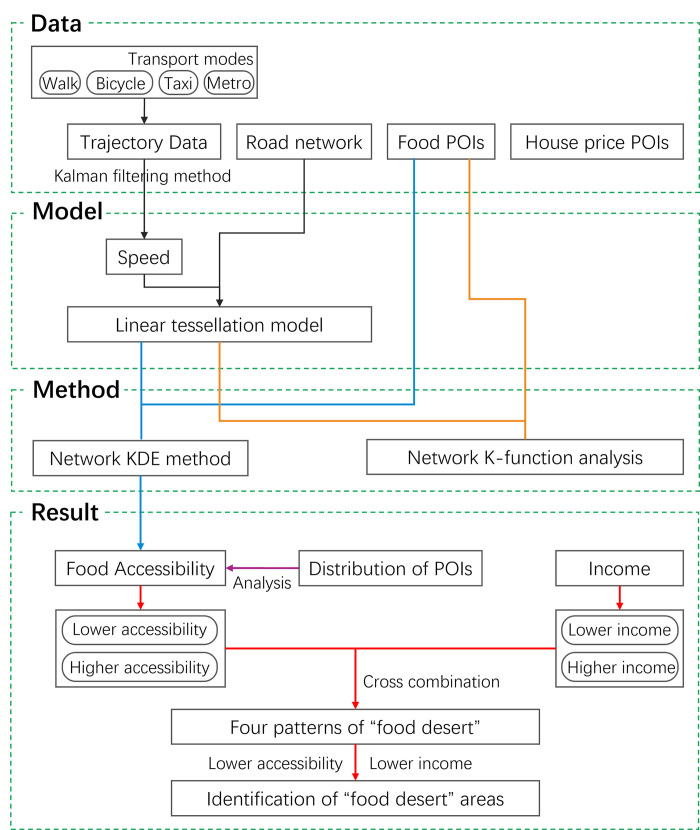
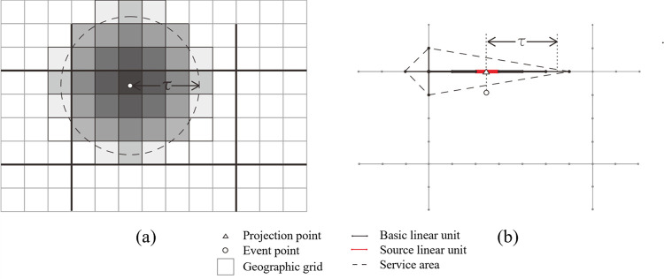
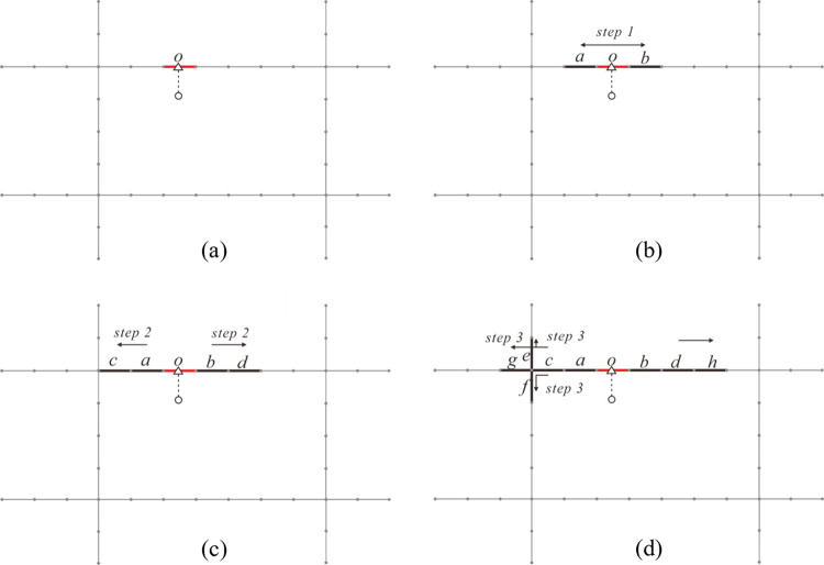
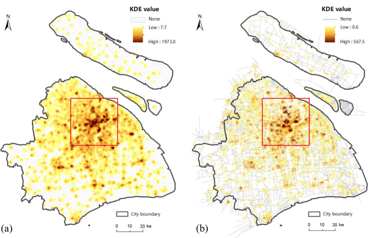
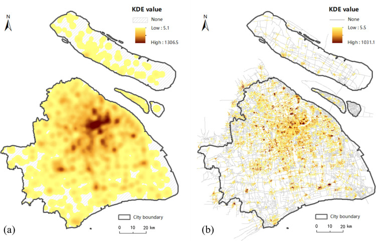
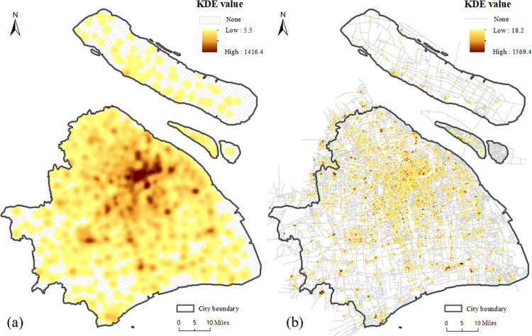
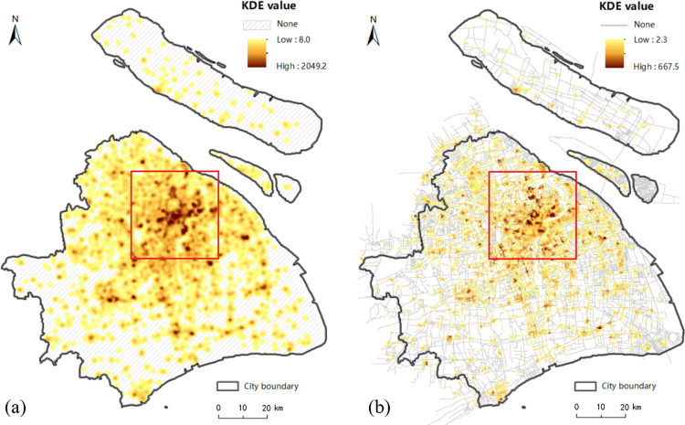
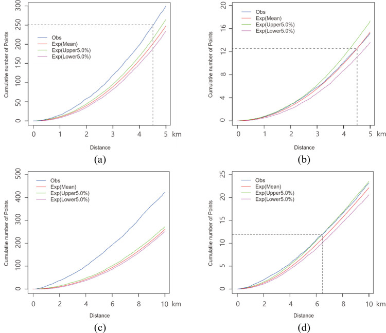
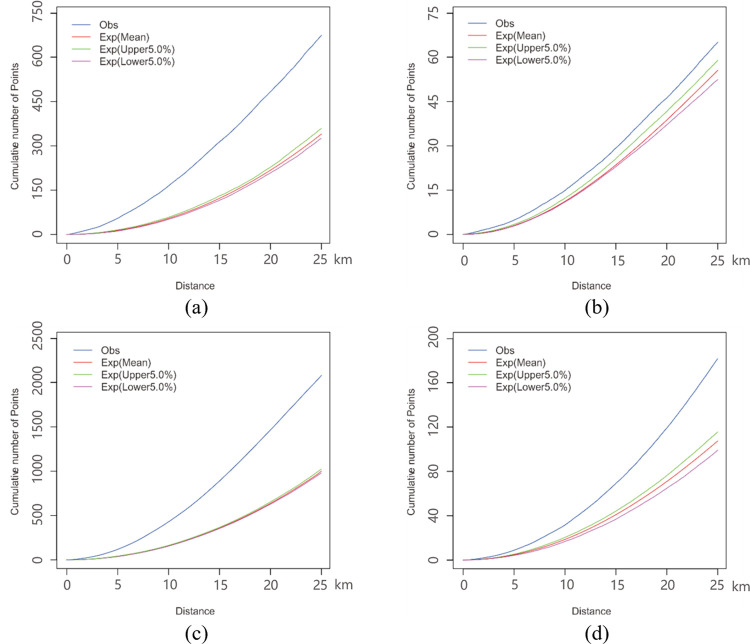
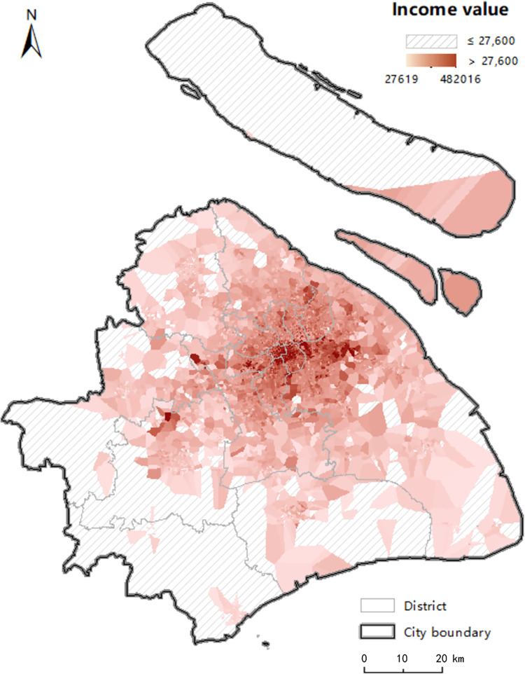
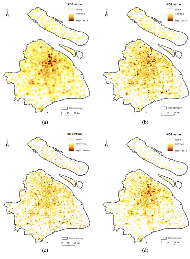
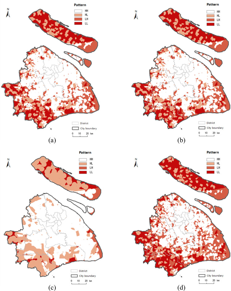
The "food desert" problem has been treated under a national strategy in the United States and other countries. At present, there is little research on the phenomenon of "food desert" in China. This study takes Shanghai as the research area and proposes a multiscale analysis method using a linear tessellation model that splits the street network into homogeneous linear units. Firstly, the network kernel density estimation using a linear tessellation model is used to measure the travel-mode-based food accessibility. Considering the actual travel constraints, the GPS trajectory data of four travel modes (walking, bicycle, metro and taxi) are applied to calculate the speed of each linear unit. Secondly, the "food desert" phenomenon in Shanghai are identified combing with the results of the network K-function. Finally, the resident income conditions in different modes are fitted based on the housing price data and the spatial distribution of four "food desert" patterns are detected by the overlay analysis of food accessibility and resident income conditions. The experimental results show that fifty percent of Shanghai is characterized by low food accessibility, and half of these areas are disadvantaged and low-income areas in suburbs, which are the locations experiencing the "food desert" phenomenon. Comparing the results of the proposed method and that of the traditional planar method, the identification results for all modes based on the traditional planar method underestimate the severity of the "food desert", especially for the bicycle and taxi modes. This study also provides corresponding decision-making reference for the alleviation and resolution of "food desert" issues. Moreover, the proposed method provides a new research perspective for urban research under the street network space.

摘要

“食物沙漠”问题在美国和其他国家已在国家战略下得到处理。目前,中国对“食物沙漠”现象的研究较少。本研究以上海为研究区域,提出一种多尺度分析方法,该方法使用线性镶嵌模型将街道网络划分为同质线性单元。首先,使用线性镶嵌模型的网络核密度估计来衡量基于出行模式的食物可达性。考虑到实际出行限制,应用四种出行模式(步行、自行车、地铁和出租车)的GPS轨迹数据来计算每个线性单元的速度。其次,结合网络K函数的结果识别上海的“食物沙漠”现象。最后,基于房价数据拟合不同模式下的居民收入状况,并通过食物可达性与居民收入状况的叠加分析检测四种“食物沙漠”模式的空间分布。实验结果表明,上海50%的区域食物可达性较低,其中一半区域位于郊区的弱势和低收入地区,这些地区正经历“食物沙漠”现象。将所提方法与传统平面方法的结果进行比较,基于传统平面方法的所有模式的识别结果均低估了“食物沙漠”的严重程度,尤其是自行车和出租车模式。本研究还为缓解和解决“食物沙漠”问题提供了相应的决策参考。此外,所提方法为街道网络空间下的城市研究提供了新的研究视角。

https://cdn.ncbi.nlm.nih.gov/pmc/blobs/10de/11753656/9830a591b0e4/pone.0317003.g015.jpg
https://cdn.ncbi.nlm.nih.gov/pmc/blobs/10de/11753656/a6db8bd9fec8/pone.0317003.g001.jpg
https://cdn.ncbi.nlm.nih.gov/pmc/blobs/10de/11753656/e950e9d6f74c/pone.0317003.g002.jpg
https://cdn.ncbi.nlm.nih.gov/pmc/blobs/10de/11753656/8c27dac5bd6d/pone.0317003.g003.jpg
https://cdn.ncbi.nlm.nih.gov/pmc/blobs/10de/11753656/dbb844e91027/pone.0317003.g004.jpg
https://cdn.ncbi.nlm.nih.gov/pmc/blobs/10de/11753656/b3b2f61feb2c/pone.0317003.g005.jpg
https://cdn.ncbi.nlm.nih.gov/pmc/blobs/10de/11753656/20e2ccc7f082/pone.0317003.g006.jpg
https://cdn.ncbi.nlm.nih.gov/pmc/blobs/10de/11753656/918f025d00c4/pone.0317003.g007.jpg
https://cdn.ncbi.nlm.nih.gov/pmc/blobs/10de/11753656/e0d9a9e33c37/pone.0317003.g008.jpg
https://cdn.ncbi.nlm.nih.gov/pmc/blobs/10de/11753656/13f2a80e73a3/pone.0317003.g009.jpg
https://cdn.ncbi.nlm.nih.gov/pmc/blobs/10de/11753656/8592dcbff72b/pone.0317003.g010.jpg
https://cdn.ncbi.nlm.nih.gov/pmc/blobs/10de/11753656/6e753d99483b/pone.0317003.g011.jpg
https://cdn.ncbi.nlm.nih.gov/pmc/blobs/10de/11753656/e6c21d2302b5/pone.0317003.g012.jpg
https://cdn.ncbi.nlm.nih.gov/pmc/blobs/10de/11753656/fbc9123d0c7c/pone.0317003.g013.jpg
https://cdn.ncbi.nlm.nih.gov/pmc/blobs/10de/11753656/0da406ed0699/pone.0317003.g014.jpg
https://cdn.ncbi.nlm.nih.gov/pmc/blobs/10de/11753656/9830a591b0e4/pone.0317003.g015.jpg

相似文献

1
A linear tessellation model for the identification of "food desert": A case study of Shanghai, China.一种用于识别“食物荒漠”的线性镶嵌模型:以上海为例的案例研究
PLoS One. 2025 Jan 22;20(1):e0317003. doi: 10.1371/journal.pone.0317003. eCollection 2025.
2
The dynamics of food shopping behavior: Exploring travel patterns in low-income Detroit neighborhoods experiencing extreme disinvestment using agent-based modeling.食品购物行为的动态变化:利用基于主体的建模方法探索经历极度投资不足的底特律低收入社区的出行模式。
PLoS One. 2020 Dec 21;15(12):e0243501. doi: 10.1371/journal.pone.0243501. eCollection 2020.
3
Measuring the Destination Accessibility of Cycling Transfer Trips in Metro Station Areas: A Big Data Approach.基于大数据的地铁站区自行车换乘出行可达性测度。
Int J Environ Res Public Health. 2019 Jul 24;16(15):2641. doi: 10.3390/ijerph16152641.
4
Influence of the built environment on taxi travel demand based on the optimal spatial analysis unit.基于最优空间分析单元的建成环境对出租车出行需求的影响。
PLoS One. 2023 Oct 3;18(10):e0292363. doi: 10.1371/journal.pone.0292363. eCollection 2023.
5
Impact of the mixed degree of urban functions on the taxi travel demand.城市功能混合度对出租车出行需求的影响。
PLoS One. 2021 Mar 4;16(3):e0247431. doi: 10.1371/journal.pone.0247431. eCollection 2021.
6
Street centrality and vitality of a healthy catering industry: A case study of Jinan, China.街道中心性与健康餐饮业活力:以中国济南为例。
Front Public Health. 2022 Nov 24;10:1032668. doi: 10.3389/fpubh.2022.1032668. eCollection 2022.
7
An SCM-G2SFCA Model for Studying Spatial Accessibility of Urban Parks.用于研究城市公园空间可达性的 SCM-G2SFCA 模型。
Int J Environ Res Public Health. 2022 Dec 30;20(1):714. doi: 10.3390/ijerph20010714.
8
Health research needs more comprehensive accessibility measures: integrating time and transport modes from open data.健康研究需要更全面的可及性措施:整合来自开放数据的时间和交通方式。
Int J Health Geogr. 2016 Jul 28;15(1):23. doi: 10.1186/s12942-016-0052-x.
9
Community adaptations to an impending food desert in rural Appalachia, USA.美国阿巴拉契亚农村地区针对即将出现的食物荒漠的社区适应措施。
Rural Remote Health. 2016 Oct-Dec;16(4):3901. Epub 2016 Nov 3.
10
Geographical accessibility and spatial coverage modeling of the primary health care network in the Western Province of Rwanda.卢旺达西部初级卫生保健网络的地理可达性和空间覆盖建模。
Int J Health Geogr. 2012 Sep 17;11:40. doi: 10.1186/1476-072X-11-40.

本文引用的文献

1
Hotspots of road traffic crashes in a redeveloping area of Shanghai.上海一个再开发区域道路交通碰撞事故的热点地区
Int J Inj Contr Saf Promot. 2018 Sep;25(3):293-302. doi: 10.1080/17457300.2018.1431938. Epub 2018 Feb 12.
2
Do the risk factors for type 2 diabetes mellitus vary by location? A spatial analysis of health insurance claims in Northeastern Germany using kernel density estimation and geographically weighted regression.2型糖尿病的风险因素是否因地区而异?使用核密度估计和地理加权回归对德国东北部医疗保险索赔进行的空间分析。
Int J Health Geogr. 2016 Nov 3;15(1):38. doi: 10.1186/s12942-016-0068-2.
3
Scale effects in food environment research: Implications from assessing socioeconomic dimensions of supermarket accessibility in an eight-county region of South Carolina.
食品环境研究中的规模效应:南卡罗来纳州八县地区超市可达性社会经济维度评估的启示
Appl Geogr. 2016 Mar;68:20-27. doi: 10.1016/j.apgeog.2016.01.004.
4
Anonymisation of geographical distance matrices via Lipschitz embedding.通过李普希茨嵌入对地理距离矩阵进行匿名化处理。
Int J Health Geogr. 2016 Jan 7;15:1. doi: 10.1186/s12942-015-0031-7.
5
Food environment of fruits and vegetables in the territory of the Health Academy Program.健康学院项目辖区内水果和蔬菜的食物环境。
Cad Saude Publica. 2015 Nov;31 Suppl 1:159-69. doi: 10.1590/0102-311X00027114.
6
A century of the evolution of the urban area in Shenyang, China.中国沈阳城区的百年演变
PLoS One. 2014 Jun 3;9(6):e98847. doi: 10.1371/journal.pone.0098847. eCollection 2014.
7
What does SNAP benefit usage tell us about food access in low-income neighborhoods?SNAP 福利使用情况能告诉我们低收入社区的食物获取情况吗?
Soc Sci Med. 2014 Apr;107:89-99. doi: 10.1016/j.socscimed.2014.02.021. Epub 2014 Feb 15.
8
Dietary inequalities: what is the evidence for the effect of the neighbourhood food environment?饮食不平等:邻里食物环境影响的证据有哪些?
Health Place. 2014 May;27:229-42. doi: 10.1016/j.healthplace.2013.09.015. Epub 2013 Oct 17.
9
Home and work neighbourhood environments in relation to body mass index: the Multi-Ethnic Study of Atherosclerosis (MESA).家庭和工作邻里环境与体重指数的关系:动脉粥样硬化多民族研究(MESA)。
J Epidemiol Community Health. 2013 Oct;67(10):846-53. doi: 10.1136/jech-2013-202682. Epub 2013 Jul 18.
10
Clustering of unhealthy food around German schools and its influence on dietary behavior in school children: a pilot study.德国学校周边不健康食品的聚集及其对学生饮食行为的影响:一项初步研究。
Int J Behav Nutr Phys Act. 2013 May 24;10:65. doi: 10.1186/1479-5868-10-65.