Liu Miao, Xu Yanyan, Hu Yuanman, Li Chunlin, Sun Fengyun, Chen Tan
State Key Laboratory of Forest and Soil Ecology, Institute of Applied Ecology, Chinese Academy of Sciences, Shenyang, China.
State Key Laboratory of Forest and Soil Ecology, Institute of Applied Ecology, Chinese Academy of Sciences, Shenyang, China; University of Chinese Academy of Sciences, Beijing, China.
PLoS One. 2014 Jun 3;9(6):e98847. doi: 10.1371/journal.pone.0098847. eCollection 2014.
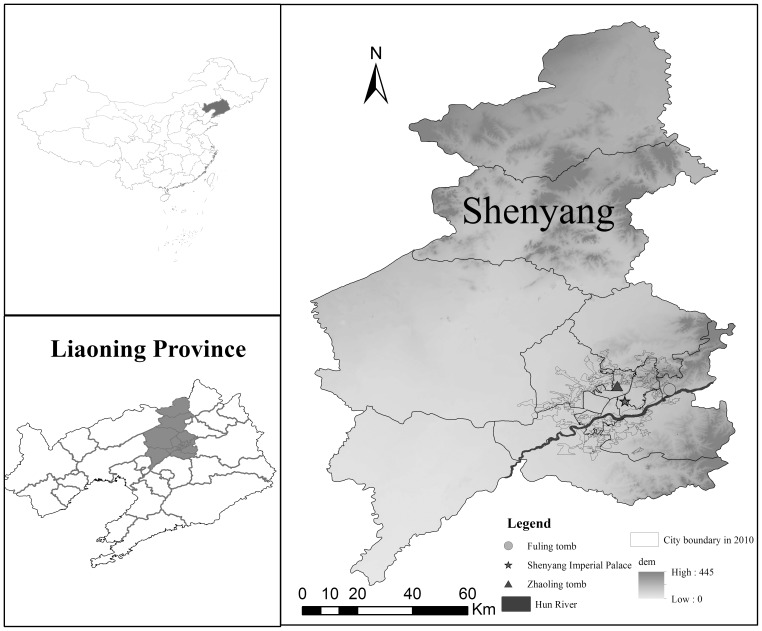
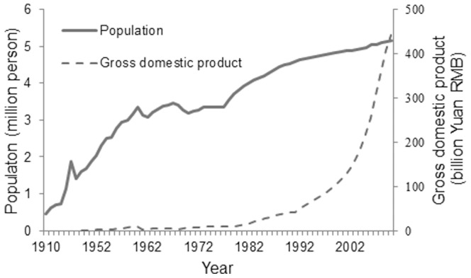
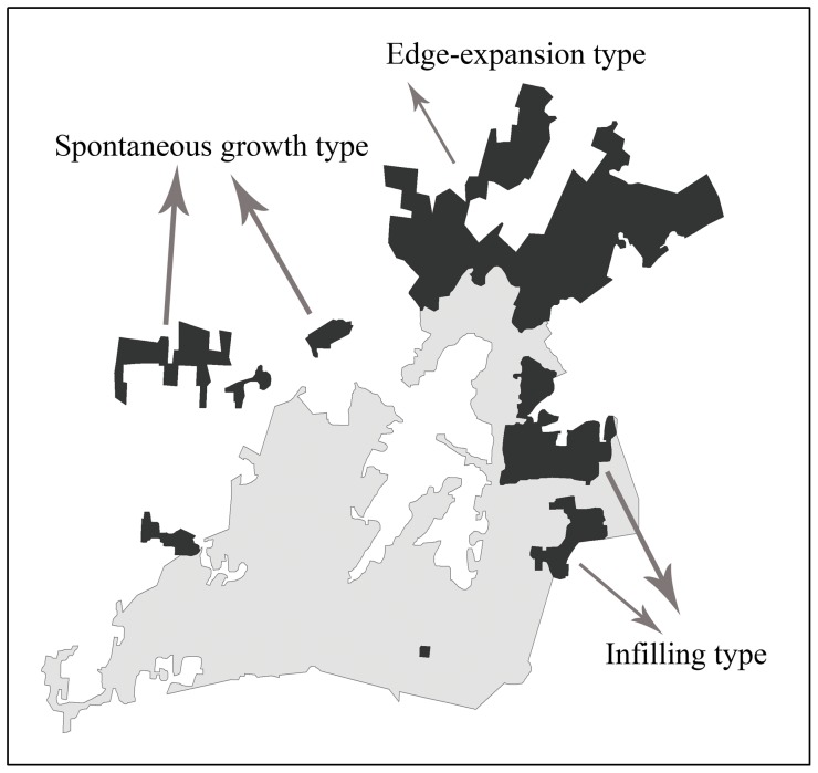
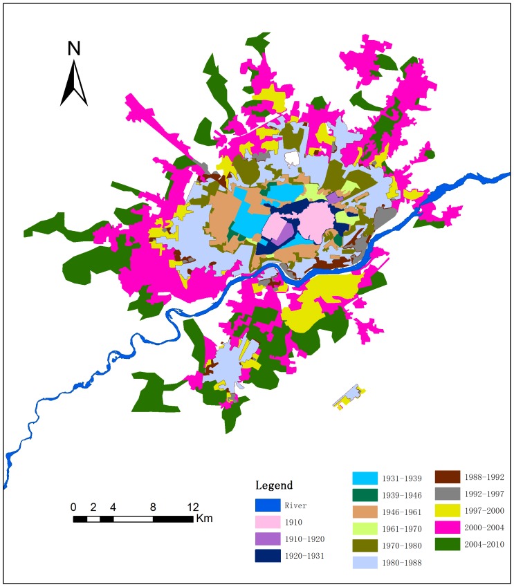
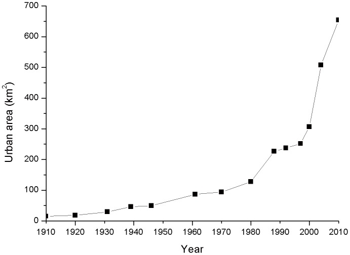
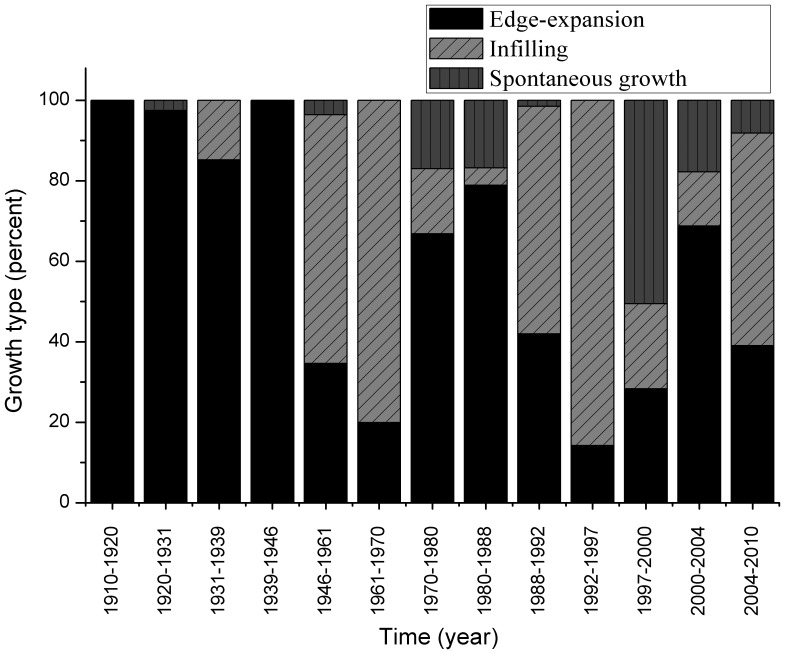
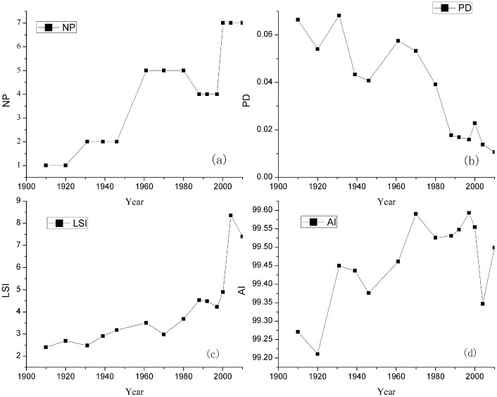
Analyzing spatiotemporal characteristics of the historical urbanization process is essential in understanding the dynamics of urbanization and scientifically planned urban development. Based on historical urban area maps and remote sensing images, this study examined the urban expansion of Shenyang from 1910 to 2010 using area statistics, typology identification, and landscape metrics approaches. The population and gross domestic product were analyzed as driving factors. The results showed that the urban area of Shenyang increased 43.39-fold during the study period and that the growth rate has accelerated since the 1980s. Three urban growth types were distinguished: infilling, edge-expansion, and spontaneous growth. Edge-expansion was the primary growth type. Infilling growth became the main growth type in the periods 1946-70, 1988-97, and 2004-10. Spontaneous growth was concentrated in the period of 1997 to 2000. The results of landscape metrics indicate that the urban landscape of Shenyang originally was highly aggregated, but has become increasingly fragmented. The urban fringe area was the traditional hot zone of urbanization. Shenyang was mainly located north of the Hun River before 1980; however, the south side of the river has been the hot zone of urbanization since the 1980s. The increase of urban area strongly correlated with the growth of GDP and population. Over a long time scale, the urbanization process has been affected by major historical events.
分析历史城市化进程的时空特征对于理解城市化动态和科学规划城市发展至关重要。基于历史城市面积图和遥感影像,本研究采用面积统计、类型识别和景观指标方法,考察了1910年至2010年沈阳的城市扩张情况。分析了人口和国内生产总值作为驱动因素。结果表明,研究期间沈阳城市面积增长了43.39倍,且自20世纪80年代以来增长率加快。区分了三种城市增长类型:填充式、边缘扩张式和自发式增长。边缘扩张是主要的增长类型。填充式增长在1946 - 1970年、1988 - 1997年和2004 - 2010年期间成为主要增长类型。自发式增长集中在1997年至2000年期间。景观指标结果表明,沈阳城市景观最初高度集聚,但后来日益破碎化。城市边缘地区是传统的城市化热点区域。1980年前沈阳主要位于浑河北岸;然而,自20世纪80年代以来,浑河南岸一直是城市化热点区域。城市面积的增加与国内生产总值和人口增长密切相关。在长期时间尺度上,城市化进程受到重大历史事件的影响。