Li Jun-Jie, Fang Yi-Hao, Zhan Ji-Cong, Yang Xue-Jun, Huang Can-Bin, Li Yan-Peng, Tan Kun, Huang Zhi-Pang, Cui Liang-Wei, Xiao Wen
Institute of Eastern-Himalaya Biodiversity Research, Dali University, Dali, 671003, Yunnan, China.
Yunling black-and-white snub-nosed monkey observation and research station of Yunnan province, Dali, 671003, Yunnan, China.
Sci Rep. 2025 Feb 4;15(1):4270. doi: 10.1038/s41598-025-86031-w.
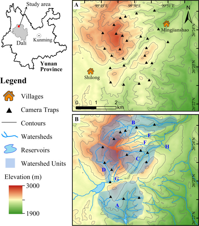
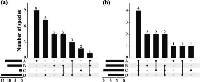
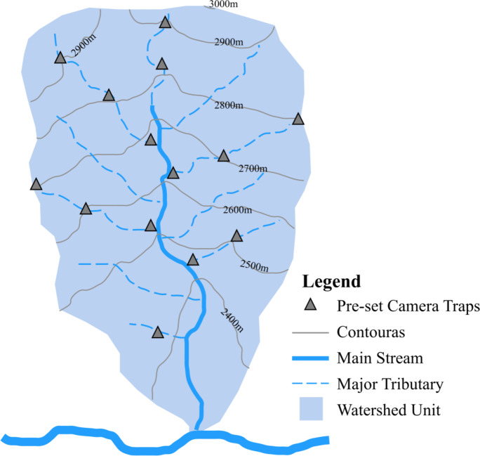
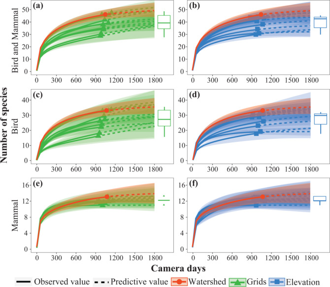
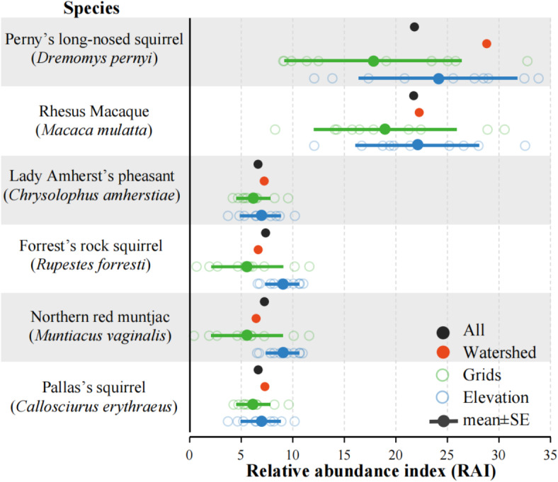
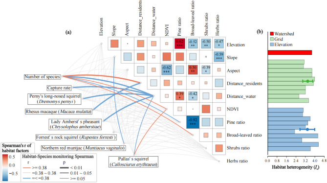
Wildlife camera trap (CT) surveys typically employ two-dimensional equal-area grid sampling, which often neglects the influence of complex mountainous terrain on species distribution, potentially yielding misleading outcomes. A watershed, incorporating diverse habitats from high to low elevations and from rivers to ridges, aligns with complex mountains. Monitoring based on watersheds might address this. In southwest China's mountain forests, under comparable sampling intensities, we contrasted the capture rate (CR), species richness, and relative abundance index (RAI) of dominant species among watershed, 1 × 1 km² grid, and elevation gradient patterns. Also, habitat factor correlations and heterogeneities were analyzed. Results reveal higher CR, species richness, and habitat heterogeneity in the watershed pattern. The elevation gradient pattern shows more stable species and RAI than the grid pattern. In small-scale mountains, topographic factors indirectly affect CT survey results via vegetation distribution. Analysis of similarities (ANOSIM) indicates significant differences in species and community among watersheds. Using watersheds as sampling units for CTs can match the mountains' elevation differences and complex topography well, aids in capturing wildlife diversity and understanding mountain species distribution. Therefore, we recommend that the spatial sample design in mountainous areas should be based on watersheds, taking elevation gradients and topography into consideration.
野生动物相机陷阱(CT)调查通常采用二维等面积网格采样,这种方法常常忽视复杂山地地形对物种分布的影响,可能会产生误导性结果。流域包含了从高海拔到低海拔、从河流到山脊的各种不同栖息地,与复杂山脉相契合。基于流域进行监测或许能解决这一问题。在中国西南部的山林中,在可比的采样强度下,我们对比了流域、1×1平方千米网格和海拔梯度模式下优势物种的捕获率(CR)、物种丰富度和相对丰度指数(RAI)。此外,还分析了栖息地因素的相关性和异质性。结果显示,流域模式下的CR、物种丰富度和栖息地异质性更高。海拔梯度模式下的物种和RAI比网格模式更稳定。在小规模山区,地形因素通过植被分布间接影响CT调查结果。相似性分析(ANOSIM)表明流域间物种和群落存在显著差异。将流域作为CT的采样单元能够很好地匹配山区的海拔差异和复杂地形,有助于捕捉野生动物多样性并了解山区物种分布。因此,我们建议山区的空间样本设计应以流域为基础,同时考虑海拔梯度和地形。