文献检索文档翻译深度研究
Suppr Zotero 插件Zotero 插件
邀请有礼套餐&价格历史记录

新学期,新优惠

限时优惠:9月1日-9月22日

30天高级会员仅需29元

1天体验卡首发特惠仅需5.99元

了解详情
不再提醒
插件&应用
Suppr Zotero 插件Zotero 插件浏览器插件Mac 客户端Windows 客户端微信小程序
高级版
套餐订阅购买积分包
AI 工具
文献检索文档翻译深度研究
关于我们
关于 Suppr公司介绍联系我们用户协议隐私条款
关注我们

Suppr 超能文献

核心技术专利:CN118964589B侵权必究
粤ICP备2023148730 号-1Suppr @ 2025

基于人工智能的山体滑坡检测与识别的YOLOv11-seg算法的应用。

Application of the YOLOv11-seg algorithm for AI-based landslide detection and recognition.

作者信息

He Luhao, Zhou Yongzhang, Liu Lei, Zhang Yuqing, Ma Jianhua

机构信息

Sun Yat-sen University Center for Earth Environment & Resources, Zhuhai, 519000, China.

School of Earth Science and Engineering, Zhuhai, 519000, China.

出版信息

Sci Rep. 2025 Apr 11;15(1):12421. doi: 10.1038/s41598-025-95959-y.


DOI:10.1038/s41598-025-95959-y
PMID:40216897
原文链接:https://pmc.ncbi.nlm.nih.gov/articles/PMC11992019/
Abstract

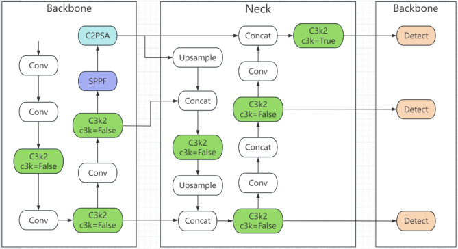
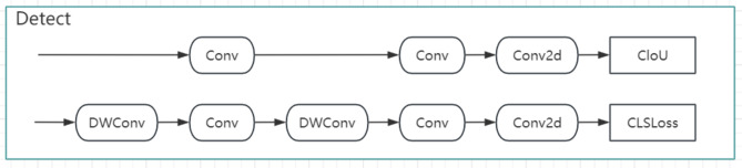
In recent years, landslides have occurred frequently around the world, resulting in significant casualties and property damage. A notable example occurred in 2014, when a landslide in the Argo region of Afghanistan claimed over 2000 lives, becoming one of the most devastating landslide events in history. The increasing frequency and severity of landslides present significant challenges to geological disaster monitoring, making the development of efficient and accurate detection methods critical for disaster mitigation and prevention. This study proposes an intelligent recognition method for landslides, which is based on the latest deep learning model, YOLOv11-seg, which is designed to address the challenges posed by complex terrains and the diverse characteristics of landslides. Using the Bijie-Landslide dataset, the method optimizes the feature extraction and segmentation modules of YOLOv11-seg, enhancing both the accuracy of landslide boundary detection and the pixel-level segmentation of landslide areas. Compared with traditional methods, YOLOv11-seg performs better in detecting complex boundaries and handling occlusion, demonstrating superior detection accuracy and segmentation quality. During the preprocessing phase, various data augmentation techniques, including mirroring, rotation, and color adjustment, were employed, significantly improving the model's generalization performance and robustness across varying terrains, seasons, and lighting conditions. The experimental results indicate that the YOLOv11-seg model excels in several key performance metrics, such as precision, recall, F1 score, and mAP. Specifically, the F1 score reaches 0.8781 for boundary detection and 0.8114 for segmentation, whereas the mAP for bounding box (B) detection and mask (M) segmentation tasks outperforms traditional methods. These results highlight the high reliability and adaptability of YOLOv11-seg for landslide detection. This research provides new technological support for intelligent landslide monitoring and risk assessment, highlighting its potential in geological disaster monitoring.

摘要

近年来,世界各地山体滑坡频繁发生,造成了重大人员伤亡和财产损失。一个显著的例子发生在2014年,阿富汗阿尔戈地区的一次山体滑坡导致2000多人丧生,成为历史上最具破坏性的山体滑坡事件之一。山体滑坡频率和严重程度的增加给地质灾害监测带来了重大挑战,因此开发高效准确的检测方法对于减灾和预防灾害至关重要。本研究提出了一种基于最新深度学习模型YOLOv11-seg的山体滑坡智能识别方法,该模型旨在应对复杂地形和山体滑坡多样特征带来的挑战。该方法使用毕节山体滑坡数据集,对YOLOv11-seg的特征提取和分割模块进行了优化,提高了山体滑坡边界检测的准确性和滑坡区域的像素级分割效果。与传统方法相比,YOLOv11-seg在检测复杂边界和处理遮挡方面表现更好,具有更高的检测精度和分割质量。在预处理阶段,采用了包括镜像、旋转和颜色调整在内的各种数据增强技术,显著提高了模型在不同地形、季节和光照条件下的泛化性能和鲁棒性。实验结果表明,YOLOv11-seg模型在精度、召回率、F1分数和平均精度均值等几个关键性能指标上表现出色。具体而言,边界检测的F1分数达到0.8781,分割的F1分数达到0.8114,而边界框(B)检测和掩码(M)分割任务的平均精度均值优于传统方法。这些结果突出了YOLOv11-seg在山体滑坡检测中的高可靠性和适应性。本研究为山体滑坡智能监测和风险评估提供了新的技术支持,凸显了其在地质灾害监测中的潜力。

https://cdn.ncbi.nlm.nih.gov/pmc/blobs/4884/11992019/29c9a12ff698/41598_2025_95959_Fig16_HTML.jpg
https://cdn.ncbi.nlm.nih.gov/pmc/blobs/4884/11992019/a010f9ca1518/41598_2025_95959_Fig1_HTML.jpg
https://cdn.ncbi.nlm.nih.gov/pmc/blobs/4884/11992019/0f81b49210d6/41598_2025_95959_Fig2_HTML.jpg
https://cdn.ncbi.nlm.nih.gov/pmc/blobs/4884/11992019/2f2e92690616/41598_2025_95959_Fig3_HTML.jpg
https://cdn.ncbi.nlm.nih.gov/pmc/blobs/4884/11992019/fd01002dfc32/41598_2025_95959_Fig4_HTML.jpg
https://cdn.ncbi.nlm.nih.gov/pmc/blobs/4884/11992019/cf5fc596d76c/41598_2025_95959_Fig5_HTML.jpg
https://cdn.ncbi.nlm.nih.gov/pmc/blobs/4884/11992019/220107fc46f0/41598_2025_95959_Fig6_HTML.jpg
https://cdn.ncbi.nlm.nih.gov/pmc/blobs/4884/11992019/6729610770b0/41598_2025_95959_Fig7_HTML.jpg
https://cdn.ncbi.nlm.nih.gov/pmc/blobs/4884/11992019/0106865dc086/41598_2025_95959_Fig8_HTML.jpg
https://cdn.ncbi.nlm.nih.gov/pmc/blobs/4884/11992019/7de8650ccbce/41598_2025_95959_Fig9_HTML.jpg
https://cdn.ncbi.nlm.nih.gov/pmc/blobs/4884/11992019/41654e5e5082/41598_2025_95959_Fig10_HTML.jpg
https://cdn.ncbi.nlm.nih.gov/pmc/blobs/4884/11992019/cb3b4372b5c9/41598_2025_95959_Fig11_HTML.jpg
https://cdn.ncbi.nlm.nih.gov/pmc/blobs/4884/11992019/2875b9e344e3/41598_2025_95959_Fig12_HTML.jpg
https://cdn.ncbi.nlm.nih.gov/pmc/blobs/4884/11992019/a0cf8ea104a2/41598_2025_95959_Fig13_HTML.jpg
https://cdn.ncbi.nlm.nih.gov/pmc/blobs/4884/11992019/2ba5396cfcde/41598_2025_95959_Fig14_HTML.jpg
https://cdn.ncbi.nlm.nih.gov/pmc/blobs/4884/11992019/f71fa57bcefc/41598_2025_95959_Fig15_HTML.jpg
https://cdn.ncbi.nlm.nih.gov/pmc/blobs/4884/11992019/29c9a12ff698/41598_2025_95959_Fig16_HTML.jpg

相似文献

[1]
Application of the YOLOv11-seg algorithm for AI-based landslide detection and recognition.

Sci Rep. 2025-4-11

[2]
ResM-FusionNet for efficient landslide detection algorithm with a hybrid architecture.

Sci Rep. 2025-4-16

[3]
Research on object detection and recognition in remote sensing images based on YOLOv11.

Sci Rep. 2025-4-23

[4]
Landslide Susceptibility Evaluation Based on Potential Disaster Identification and Ensemble Learning.

Int J Environ Res Public Health. 2022-10-31

[5]
A semantic segmentation framework with UNet-pyramid for landslide prediction using remote sensing data.

Sci Rep. 2024-12-3

[6]
A Deep-Learning-Based Algorithm for Landslide Detection over Wide Areas Using InSAR Images Considering Topographic Features.

Sensors (Basel). 2024-7-15

[7]
An ensemble learning-based experimental framework for smart landslide detection, monitoring, prediction, and warning in IoT-cloud environment.

Environ Sci Pollut Res Int. 2023-12

[8]
EMR-HRNet: A Multi-Scale Feature Fusion Network for Landslide Segmentation from Remote Sensing Images.

Sensors (Basel). 2024-6-6

[9]
A landslide area segmentation method based on an improved UNet.

Sci Rep. 2025-4-7

[10]
Integrating stratified best-worst method and GIS for landslide susceptibility assessment: a case study in Erzurum province (Turkey).

Environ Sci Pollut Res Int. 2023-11

本文引用的文献

[1]
Characterizing Surface Deformation of the Earthquake-Induced Daguangbao Landslide by Combining Satellite- and Ground-Based InSAR.

Sensors (Basel). 2024-12-26

[2]
Landslide hazard cascades can trigger earthquakes.

Nat Commun. 2024-4-8

[3]
Identification of Landslides in Mountainous Area with the Combination of SBAS-InSAR and Yolo Model.

Sensors (Basel). 2022-8-19

[4]
Comparing YOLOv3, YOLOv4 and YOLOv5 for Autonomous Landing Spot Detection in Faulty UAVs.

Sensors (Basel). 2022-1-8

[5]
Strategic protection of landslide vulnerable mountains for biodiversity conservation under land-cover and climate change impacts.

Proc Natl Acad Sci U S A. 2022-1-11

[6]
Convolutional neural network (CNN) with metaheuristic optimization algorithms for landslide susceptibility mapping in Icheon, South Korea.

J Environ Manage. 2022-3-1

[7]
Deep learning-based landslide susceptibility mapping.

Sci Rep. 2021-12-16

[8]
A comprehensive transferability evaluation of U-Net and ResU-Net for landslide detection from Sentinel-2 data (case study areas from Taiwan, China, and Japan).

Sci Rep. 2021-7-16

[9]
The human cost of global warming: Deadly landslides and their triggers (1995-2014).

Sci Total Environ. 2019-9-10

[10]
Landslide hazard assessment: recent trends and techniques.

Springerplus. 2013-10-17

文献AI研究员

20分钟写一篇综述,助力文献阅读效率提升50倍

立即体验

用中文搜PubMed

大模型驱动的PubMed中文搜索引擎

马上搜索

推荐工具

医学文档翻译智能文献检索