Bai Jianjun, Wang Jingshu, Li Ping, Yao Zelong, Bi Rutian
College of Resources and Environment, Shanxi Agricultural University, Taigu, Shanxi, China.
PLoS One. 2025 Jun 4;20(6):e0325350. doi: 10.1371/journal.pone.0325350. eCollection 2025.
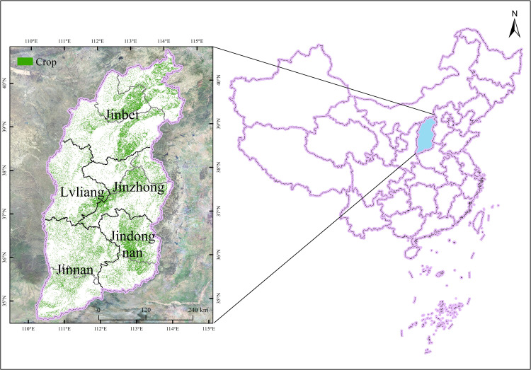
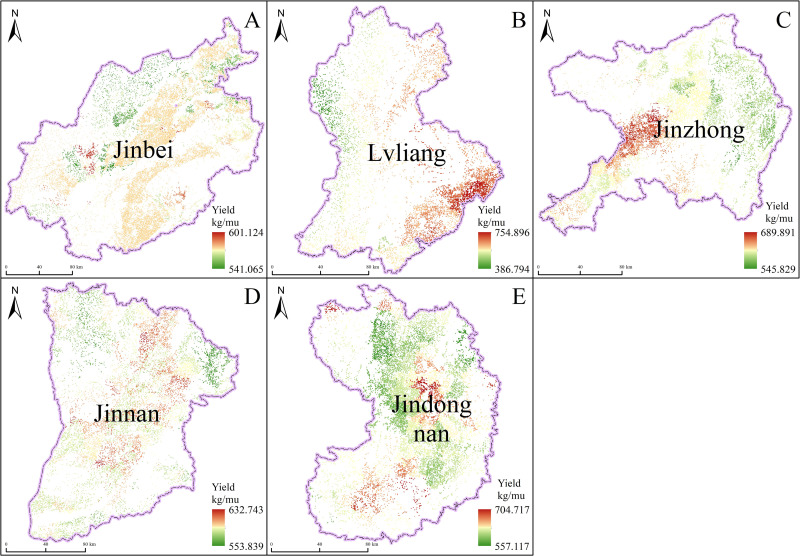
This study focuses on Shanxi Province, located in the typical rain-fed agricultural region of the Loess Plateau, where farmland water reserves are limited and water scarcity is a significant challenge. To achieve stable and high grain yields while addressing these constraints, the primary focus must be on reducing agricultural water use while balancing productivity with water conservation, provided that sufficient irrigation sources are available. The research utilized Landsat 8 satellite data and meteorological information to simulate crop evapotranspiration (ET) in Shanxi using the SEBAL model. Based on the simulated ET values and field survey data of crop yields, the study calculated crop water productivity (WP). It then analyzed the relationship between WP and natural factors such as elevation, air temperature, and precipitation. Key findings include: Crop ET in Shanxi generally increased from northeast to southwest, with simulation results closely aligning with FAO Penman-Monteith equation calculations (relative error of no more than 5%). Crop yields ranged from 386.794 to 754.896 kg/mu, with WP varying significantly across regions-from 0.824 kg/m3 in the Jindongnan district to 2.532 kg/m3 in the Jinnan district. Regional variations in crop WP were influenced by elevation, annual temperature, and precipitation patterns. Notably, the linear correlation between WP and these factors was weaker in the Lvliang mountainous area. These findings emphasize the importance of implementing appropriate field management practices (e.g., optimized irrigation scheduling, soil moisture management) to improve both crop yields and WP.
本研究聚焦于位于黄土高原典型雨养农业区的山西省,该地区农田水资源储备有限,水资源短缺是一项重大挑战。为在应对这些限制因素的同时实现稳定高产的粮食产量,在有充足灌溉水源的前提下,首要重点必须是减少农业用水,同时平衡生产力与水资源保护。该研究利用Landsat 8卫星数据和气象信息,采用SEBAL模型模拟山西省的作物蒸散量(ET)。基于模拟的ET值和作物产量的实地调查数据,该研究计算了作物水分生产率(WP)。然后分析了WP与海拔、气温和降水等自然因素之间的关系。主要研究结果包括:山西省的作物ET总体上从东北向西南增加,模拟结果与粮农组织彭曼-蒙特斯方程计算结果密切吻合(相对误差不超过5%)。作物产量在386.794至754.896公斤/亩之间,WP在不同地区差异显著——从晋东南地区的0.824公斤/立方米到晋南地区的2.532公斤/立方米。作物WP的区域差异受海拔、年气温和降水模式的影响。值得注意的是,吕梁山区WP与这些因素之间的线性相关性较弱。这些研究结果强调了实施适当的田间管理措施(如优化灌溉调度、土壤水分管理)以提高作物产量和WP的重要性。