• 文献检索
  • 文档翻译
  • 深度研究
  • 学术资讯
  • Suppr Zotero 插件Zotero 插件
  • 邀请有礼
  • 套餐&价格
  • 历史记录
应用&插件
Suppr Zotero 插件Zotero 插件浏览器插件Mac 客户端Windows 客户端微信小程序
定价
高级版会员购买积分包购买API积分包
服务
文献检索文档翻译深度研究API 文档MCP 服务
关于我们
关于 Suppr公司介绍联系我们用户协议隐私条款
关注我们

Suppr 超能文献

核心技术专利:CN118964589B侵权必究
粤ICP备2023148730 号-1Suppr @ 2026

文献检索

告别复杂PubMed语法,用中文像聊天一样搜索,搜遍4000万医学文献。AI智能推荐,让科研检索更轻松。

立即免费搜索

文件翻译

保留排版,准确专业,支持PDF/Word/PPT等文件格式,支持 12+语言互译。

免费翻译文档

深度研究

AI帮你快速写综述,25分钟生成高质量综述,智能提取关键信息,辅助科研写作。

立即免费体验

一种基于RGB的半自动方法,用于使用QGIS集成的无人机工作流程检测野生动物对农作物的损害。

A Semi-Automated RGB-Based Method for Wildlife Crop Damage Detection Using QGIS-Integrated UAV Workflow.

作者信息

Banaszek Sebastian, Szota Michał

机构信息

Institute of Geodesy and Cartography, 27 Modzelewski Street, 02-679 Warsaw, Poland.

Fire Academy, 52/54 Slowackiego Street, 01-629 Warsaw, Poland.

出版信息

Sensors (Basel). 2025 Jul 31;25(15):4734. doi: 10.3390/s25154734.

DOI:10.3390/s25154734
PMID:40807897
原文链接:https://pmc.ncbi.nlm.nih.gov/articles/PMC12349311/
Abstract

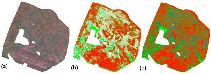
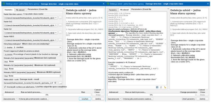
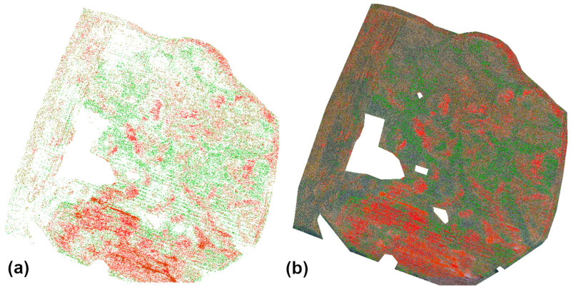
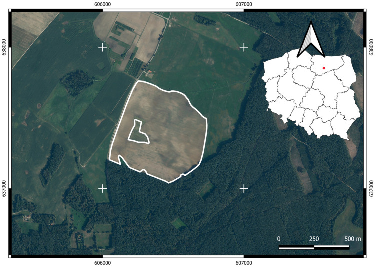
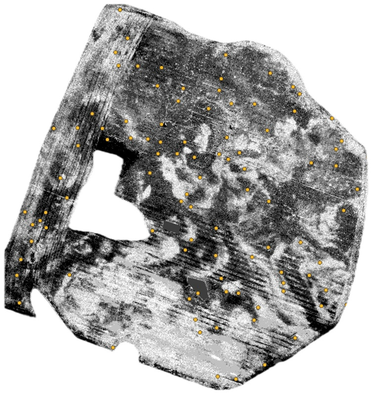
Monitoring crop damage caused by wildlife remains a significant challenge in agricultural management, particularly in the case of large-scale monocultures such as maize. The given study presents a semi-automated process for detecting wildlife-induced damage using RGB imagery acquired from unmanned aerial vehicles (UAVs). The method is designed for non-specialist users and is fully integrated within the QGIS platform. The proposed approach involves calculating three vegetation indices-Excess Green (ExG), Green Leaf Index (GLI), and Modified Green-Red Vegetation Index (MGRVI)-based on a standardized orthomosaic generated from RGB images collected via UAV. Subsequently, an unsupervised k-means clustering algorithm was applied to divide the field into five vegetation vigor classes. Within each class, 25% of the pixels with the lowest average index values were preliminarily classified as damaged. A dedicated QGIS plugin enables drone data analysts (Drone Data Analysts-DDAs) to adjust index thresholds, based on visual interpretation, interactively. The method was validated on a 50-hectare maize field, where 7 hectares of damage (15% of the area) were identified. The results indicate a high level of agreement between the automated and manual classifications, with an overall accuracy of 81%. The highest concentration of damage occurred in the "moderate" and "low" vigor zones. Final products included vigor classification maps, binary damage masks, and summary reports in HTML and DOCX formats with visualizations and statistical data. The results confirm the effectiveness and scalability of the proposed RGB-based procedure for crop damage assessment. The method offers a repeatable, cost-effective, and field-operable alternative to multispectral or AI-based approaches, making it suitable for integration with precision agriculture practices and wildlife population management.

摘要

监测野生动物对农作物造成的损害仍然是农业管理中的一项重大挑战,尤其是在玉米等大规模单一作物种植的情况下。本研究提出了一种半自动流程,用于使用从无人机(UAV)获取的RGB图像检测野生动物造成的损害。该方法是为非专业用户设计的,并完全集成在QGIS平台内。所提出的方法包括基于通过无人机收集的RGB图像生成的标准化正射镶嵌图计算三个植被指数——过量绿色指数(ExG)、绿叶指数(GLI)和修正的绿红植被指数(MGRVI)。随后,应用无监督k均值聚类算法将田地划分为五个植被活力等级。在每个等级中,平均指数值最低的25%的像素被初步分类为受损像素。一个专门的QGIS插件使无人机数据分析人员(Drone Data Analysts-DDAs)能够根据视觉解释交互式地调整指数阈值。该方法在一个50公顷的玉米田上进行了验证,在该玉米田中识别出了7公顷的受损区域(占总面积的15%)。结果表明,自动分类和人工分类之间具有高度一致性,总体准确率为81%。受损最集中的区域出现在“中等”和“低”活力区。最终产品包括活力分类图、二元损害掩码以及HTML和DOCX格式的总结报告,其中包含可视化和统计数据。结果证实了所提出的基于RGB的作物损害评估程序的有效性和可扩展性。该方法为多光谱或基于人工智能的方法提供了一种可重复、经济高效且可在田间操作的替代方案,使其适合与精准农业实践和野生动物种群管理相结合。

https://cdn.ncbi.nlm.nih.gov/pmc/blobs/af6c/12349311/04f7995a674b/sensors-25-04734-g008.jpg
https://cdn.ncbi.nlm.nih.gov/pmc/blobs/af6c/12349311/dbee5125d085/sensors-25-04734-g001.jpg
https://cdn.ncbi.nlm.nih.gov/pmc/blobs/af6c/12349311/daabfa5a0ae7/sensors-25-04734-g002.jpg
https://cdn.ncbi.nlm.nih.gov/pmc/blobs/af6c/12349311/c83ead91d7b0/sensors-25-04734-g003.jpg
https://cdn.ncbi.nlm.nih.gov/pmc/blobs/af6c/12349311/20eb0d9a70aa/sensors-25-04734-g004.jpg
https://cdn.ncbi.nlm.nih.gov/pmc/blobs/af6c/12349311/d33675b22a61/sensors-25-04734-g005.jpg
https://cdn.ncbi.nlm.nih.gov/pmc/blobs/af6c/12349311/59279f178edb/sensors-25-04734-g006.jpg
https://cdn.ncbi.nlm.nih.gov/pmc/blobs/af6c/12349311/3836d5227beb/sensors-25-04734-g007.jpg
https://cdn.ncbi.nlm.nih.gov/pmc/blobs/af6c/12349311/04f7995a674b/sensors-25-04734-g008.jpg

相似文献

1
A Semi-Automated RGB-Based Method for Wildlife Crop Damage Detection Using QGIS-Integrated UAV Workflow.一种基于RGB的半自动方法,用于使用QGIS集成的无人机工作流程检测野生动物对农作物的损害。
Sensors (Basel). 2025 Jul 31;25(15):4734. doi: 10.3390/s25154734.
2
Characterization of Hazelnut Trees in Open Field Through High-Resolution UAV-Based Imagery and Vegetation Indices.通过基于无人机的高分辨率影像和植被指数对开阔地榛子树进行特征描述
Sensors (Basel). 2025 Jan 6;25(1):288. doi: 10.3390/s25010288.
3
Remote sensing for precision weed management.用于精准杂草管理的遥感技术
Pest Manag Sci. 2025 Apr 17. doi: 10.1002/ps.8833.
4
Detection of weeds in teff crops using deep learning and UAV imagery for precision herbicide application.利用深度学习和无人机图像检测埃塞俄比亚画眉草作物中的杂草以实现精准除草剂施用
Sci Rep. 2025 Aug 21;15(1):30708. doi: 10.1038/s41598-025-15380-3.
5
Prescription of Controlled Substances: Benefits and Risks管制药品的处方:益处与风险
6
Integrated neural network framework for multi-object detection and recognition using UAV imagery.用于使用无人机图像进行多目标检测与识别的集成神经网络框架。
Front Neurorobot. 2025 Jul 30;19:1643011. doi: 10.3389/fnbot.2025.1643011. eCollection 2025.
7
Automated devices for identifying peripheral arterial disease in people with leg ulceration: an evidence synthesis and cost-effectiveness analysis.用于识别下肢溃疡患者外周动脉疾病的自动化设备:证据综合和成本效益分析。
Health Technol Assess. 2024 Aug;28(37):1-158. doi: 10.3310/TWCG3912.
8
Aerial image segmentation of embankment dams based on multispectral remote sensing: a case study in the Belo Monte Hydroelectric Complex, Pará, Brazil.基于多光谱遥感的堤坝式水坝航空图像分割:以巴西帕拉州贝洛蒙特水电站综合体为例
PeerJ Comput Sci. 2025 Jun 16;11:e2917. doi: 10.7717/peerj-cs.2917. eCollection 2025.
9
Detecting and distinguishing between apicultural plants using UAV multispectral imaging.利用无人机多光谱成像技术检测和区分养蜂植物。
PeerJ. 2023 Apr 14;11:e15065. doi: 10.7717/peerj.15065. eCollection 2023.
10
Using image segmentation models to analyse high-resolution earth observation data: new tools to monitor disease risks in changing environments.利用图像分割模型分析高分辨率地球观测数据:监测变化环境中疾病风险的新工具。
Int J Health Geogr. 2024 May 19;23(1):13. doi: 10.1186/s12942-024-00371-w.

本文引用的文献

1
Symmetry of Wild Boar Damage to Agricultural Crops: Results of over 20 Years of Damage Monitoring in Central Europe.野猪对农作物损害的对称性:中欧20多年损害监测结果
Animals (Basel). 2025 May 29;15(11):1587. doi: 10.3390/ani15111587.
2
Spatial risk patches of the Indian crested porcupine crop damage in southeastern Iran.伊朗东南部印度豪猪造成作物损害的空间风险斑块。
Sci Rep. 2025 May 2;15(1):15359. doi: 10.1038/s41598-025-00232-x.
3
A Systematic Review on the Advancements in Remote Sensing and Proximity Tools for Grapevine Disease Detection.
关于用于葡萄病害检测的遥感和近程工具进展的系统综述
Sensors (Basel). 2024 Dec 21;24(24):8172. doi: 10.3390/s24248172.