School of Biodiversity, One Health & Veterinary Medicine, University of Glasgow, Glasgow, Scotland, UK.
School of Geographical & Earth Sciences, University of Glasgow, Glasgow, Scotland, UK.
Int J Health Geogr. 2024 May 19;23(1):13. doi: 10.1186/s12942-024-00371-w.
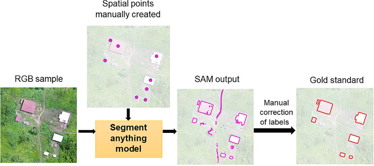
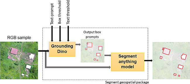
In the near future, the incidence of mosquito-borne diseases may expand to new sites due to changes in temperature and rainfall patterns caused by climate change. Therefore, there is a need to use recent technological advances to improve vector surveillance methodologies. Unoccupied Aerial Vehicles (UAVs), often called drones, have been used to collect high-resolution imagery to map detailed information on mosquito habitats and direct control measures to specific areas. Supervised classification approaches have been largely used to automatically detect vector habitats. However, manual data labelling for model training limits their use for rapid responses. Open-source foundation models such as the Meta AI Segment Anything Model (SAM) can facilitate the manual digitalization of high-resolution images. This pre-trained model can assist in extracting features of interest in a diverse range of images. Here, we evaluated the performance of SAM through the Samgeo package, a Python-based wrapper for geospatial data, as it has not been applied to analyse remote sensing images for epidemiological studies.
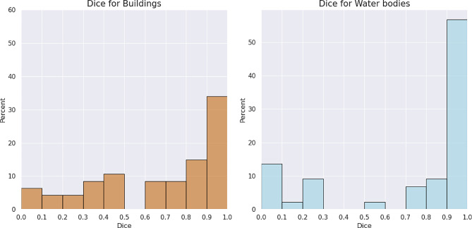
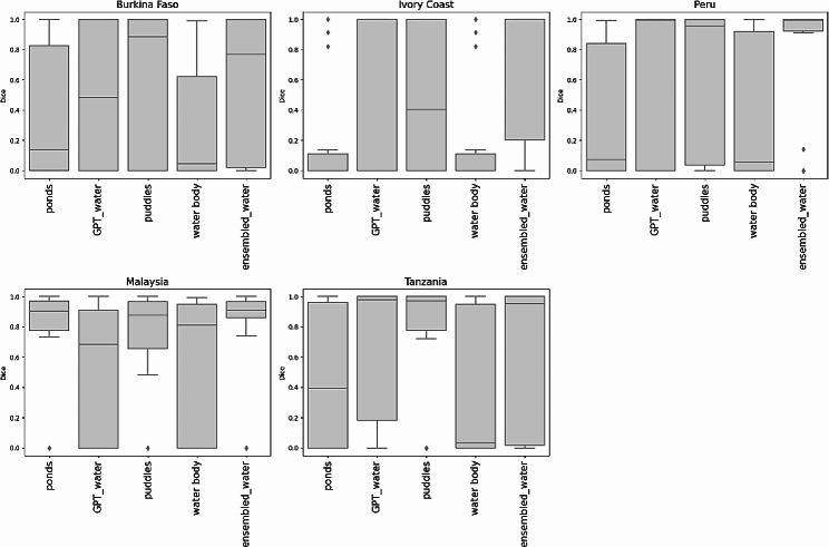
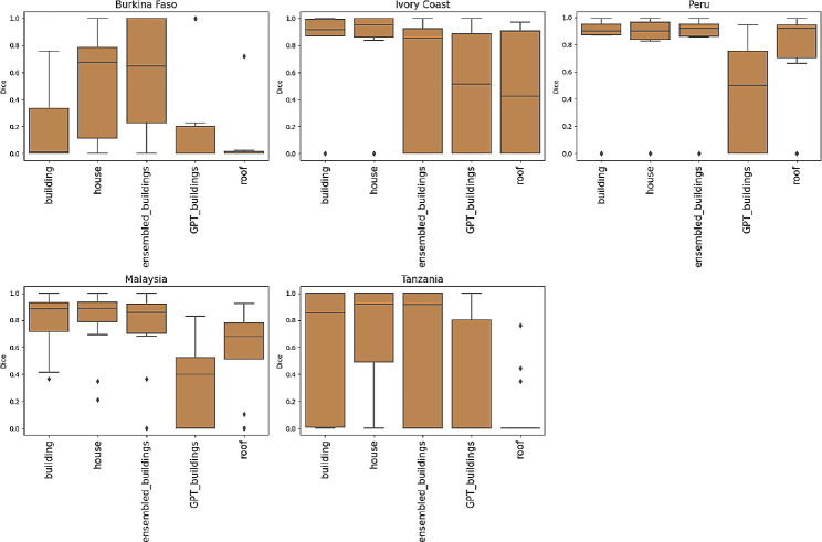
We tested the identification of two land cover classes of interest: water bodies and human settlements, using different UAV acquired imagery across five malaria-endemic areas in Africa, South America, and Southeast Asia. We employed manually placed point prompts and text prompts associated with specific classes of interest to guide the image segmentation and assessed the performance in the different geographic contexts. An average Dice coefficient value of 0.67 was obtained for buildings segmentation and 0.73 for water bodies using point prompts. Regarding the use of text prompts, the highest Dice coefficient value reached 0.72 for buildings and 0.70 for water bodies. Nevertheless, the performance was closely dependent on each object, landscape characteristics and selected words, resulting in varying performance.
Recent models such as SAM can potentially assist manual digitalization of imagery by vector control programs, quickly identifying key features when surveying an area of interest. However, accurate segmentation still requires user-provided manual prompts and corrections to obtain precise segmentation. Further evaluations are necessary, especially for applications in rural areas.
由于气候变化导致的温度和降雨模式的变化,未来蚊媒疾病的发病率可能会扩展到新的地区。因此,需要利用最近的技术进步来改进媒介监测方法。无人飞行器(UAV),通常称为无人机,已被用于收集高分辨率图像,以绘制详细的蚊子栖息地信息,并将控制措施直接指向特定区域。监督分类方法已被广泛用于自动检测媒介栖息地。然而,模型训练的手动数据标记限制了它们在快速响应中的使用。像 Meta AI Segment Anything 模型(SAM)这样的开源基础模型可以促进高分辨率图像的手动数字化。这个预训练模型可以帮助提取各种图像中感兴趣的特征。在这里,我们通过基于 Python 的地理空间数据包装器 Samgeo 包评估了 SAM 的性能,因为它尚未应用于分析遥感图像进行流行病学研究。
我们测试了通过手动放置点提示和与特定感兴趣类相关的文本提示来识别两种感兴趣的土地覆盖类:水体和人类住区,使用了来自非洲、南美洲和东南亚五个疟疾流行地区的不同无人机获取的图像。我们评估了不同地理环境中的性能。使用点提示,建筑物分割的平均骰子系数值为 0.67,水体分割的平均骰子系数值为 0.73。关于文本提示的使用,建筑物的最高骰子系数值达到 0.72,水体的最高骰子系数值达到 0.70。然而,性能密切依赖于每个对象、景观特征和所选的单词,因此性能会有所不同。
像 SAM 这样的最新模型可以通过控制项目手动快速识别感兴趣区域的关键特征,从而辅助图像的手动数字化。然而,要获得精确的分割,仍然需要用户提供的手动提示和修正。需要进一步评估,特别是在农村地区的应用。