Wimberly Michael C, Hildreth Michael B, Boyte Stephen P, Lindquist Erik, Kightlinger Lon
Geographic Information Science Center of Excellence, South Dakota State University, Brookings, South Dakota, United States of America.
PLoS One. 2008;3(12):e3744. doi: 10.1371/journal.pone.0003744. Epub 2008 Dec 5.
The incidence of West Nile virus (WNv) has remained high in the northern Great Plains compared to the rest of the United States. However, the reasons for the sustained high risk of WNv transmission in this region have not been determined. To assess the environmental drivers of WNv in the northern Great Plains, we analyzed the county-level spatial pattern of human cases during the 2003 epidemic across a seven-state region.
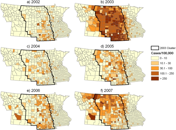
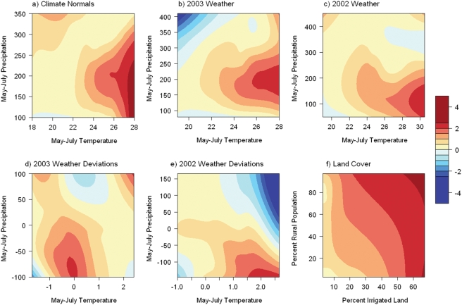
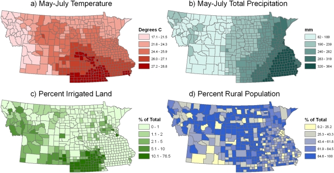
METHODOLOGY/PRINCIPAL FINDINGS: County-level data on WNv cases were examined using spatial cluster analysis, and were used to fit statistical models with weather, climate, and land use variables as predictors. In 2003 there was a single large cluster of elevated WNv risk encompassing North Dakota, South Dakota, and Nebraska along with portions of eastern Montana and Wyoming. The relative risk of WNv remained high within the boundaries of this cluster from 2004-2007. WNv incidence during the 2003 epidemic was found to have a stronger relationship with long-term climate patterns than with annual weather in either 2002 or 2003. WNv incidence increased with mean May-July temperature and had a unimodal relationship with total May-July precipitation. WNv incidence also increased with the percentage of irrigated cropland and with the percentage of the human population living in rural areas.
CONCLUSIONS/SIGNIFICANCE: The spatial pattern of WNv cases during the 2003 epidemic in the northern Great Plains was associated with both climatic gradients and land use patterns. These results were interpreted as evidence that environmental conditions across much of the northern Great Plains create a favorable ecological niche for Culex tarsalis, a particularly efficient vector of WNv. Further research is needed to determine the proximal causes of sustained WNv transmission and to enhance strategies for disease prevention.
与美国其他地区相比,西尼罗河病毒(WNv)在大平原北部的发病率一直居高不下。然而,该地区WNv传播持续高风险的原因尚未确定。为了评估大平原北部WNv的环境驱动因素,我们分析了2003年疫情期间七个州地区县级人类病例的空间格局。
方法/主要发现:使用空间聚类分析检查了WNv病例的县级数据,并将其用于拟合以天气、气候和土地利用变量作为预测因子的统计模型。2003年,有一个单一的大型WNv高风险集群,涵盖北达科他州、南达科他州和内布拉斯加州,以及蒙大拿州东部和怀俄明州的部分地区。2004 - 2007年,该集群范围内WNv的相对风险仍然很高。研究发现,2003年疫情期间WNv的发病率与长期气候模式的关系比与2002年或2003年的年度天气的关系更强。WNv发病率随5 - 7月平均温度升高而增加,与5 - 7月总降水量呈单峰关系。WNv发病率还随着灌溉农田的百分比以及农村地区人口的百分比增加而增加。
结论/意义:2003年大平原北部疫情期间WNv病例的空间格局与气候梯度和土地利用模式都有关联。这些结果被解释为证据,表明大平原北部大部分地区的环境条件为西尼罗病毒的一种特别有效的传播媒介——致倦库蚊创造了有利的生态位。需要进一步研究以确定WNv持续传播的近端原因,并加强疾病预防策略。