• 文献检索
  • 文档翻译
  • 深度研究
  • 学术资讯
  • Suppr Zotero 插件Zotero 插件
  • 邀请有礼
  • 套餐&价格
  • 历史记录
应用&插件
Suppr Zotero 插件Zotero 插件浏览器插件Mac 客户端Windows 客户端微信小程序
定价
高级版会员购买积分包购买API积分包
服务
文献检索文档翻译深度研究API 文档MCP 服务
关于我们
关于 Suppr公司介绍联系我们用户协议隐私条款
关注我们

Suppr 超能文献

核心技术专利:CN118964589B侵权必究
粤ICP备2023148730 号-1Suppr @ 2026

文献检索

告别复杂PubMed语法,用中文像聊天一样搜索,搜遍4000万医学文献。AI智能推荐,让科研检索更轻松。

立即免费搜索

文件翻译

保留排版,准确专业,支持PDF/Word/PPT等文件格式,支持 12+语言互译。

免费翻译文档

深度研究

AI帮你快速写综述,25分钟生成高质量综述,智能提取关键信息,辅助科研写作。

立即免费体验

利用 GIS 进行生态管理:德克萨斯州石油活动影响的绿色评估。

Using GIS in ecological management: green assessment of the impacts of petroleum activities in the state of Texas.

机构信息

Department of Urban and Regional Planning, Jackson State University, Jackson, MS 39211, USA.

出版信息

Int J Environ Res Public Health. 2010 May;7(5):2101-30. doi: 10.3390/ijerph7052101. Epub 2010 May 4.

DOI:10.3390/ijerph7052101
PMID:20623014
原文链接:https://pmc.ncbi.nlm.nih.gov/articles/PMC2898039/
Abstract

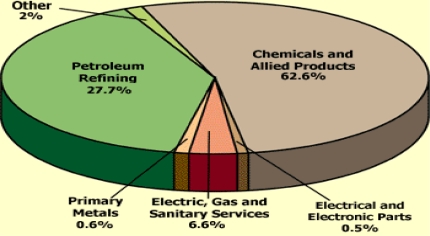
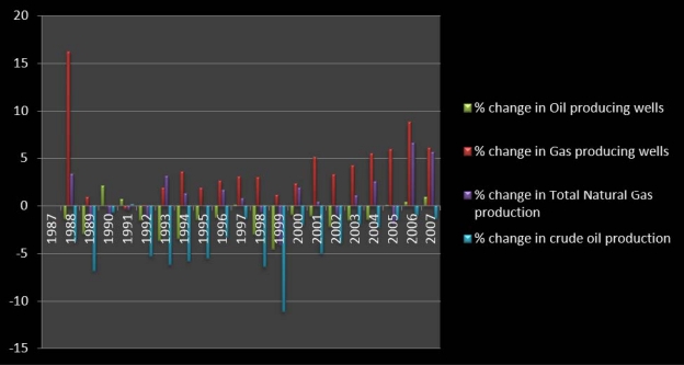
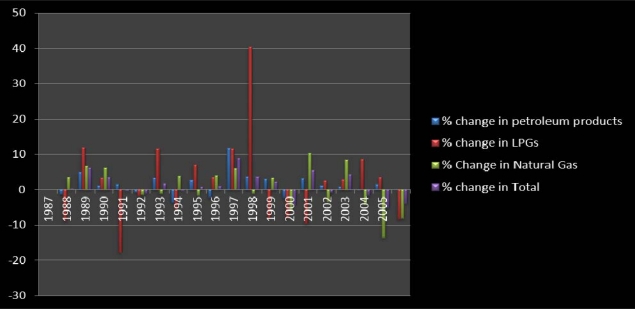
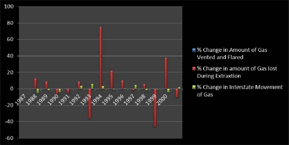
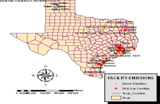
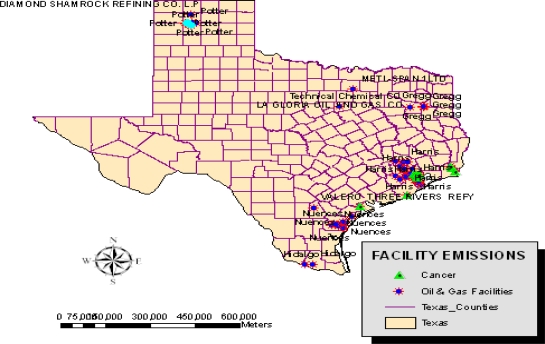
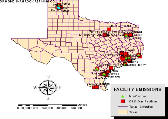
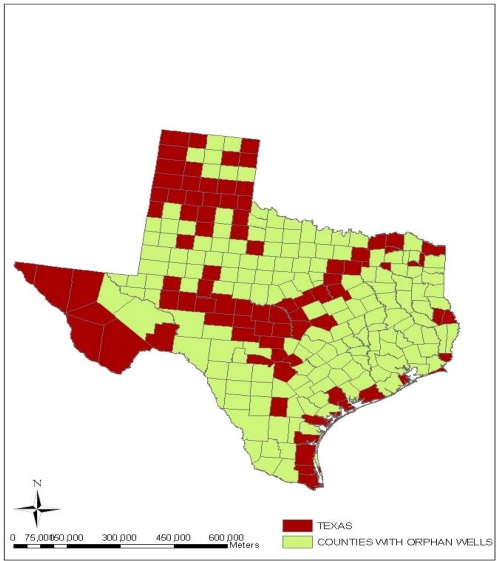
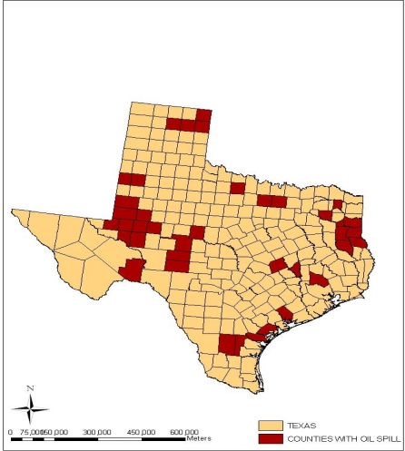
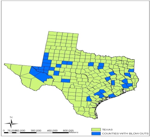
Geo-information technologies are valuable tools for ecological assessment in stressed environments. Visualizing natural features prone to disasters from the oil sector spatially not only helps in focusing the scope of environmental management with records of changes in affected areas, but it also furnishes information on the pace at which resource extraction affects nature. Notwithstanding the recourse to ecosystem protection, geo-spatial analysis of the impacts remains sketchy. This paper uses GIS and descriptive statistics to assess the ecological impacts of petroleum extraction activities in Texas. While the focus ranges from issues to mitigation strategies, the results point to growth in indicators of ecosystem decline.

摘要

地理信息技术是评估压力环境下生态状况的有力工具。从空间上展示易受石油部门影响的自然特征,不仅有助于通过受影响地区变化记录,聚焦环境管理范围,还能提供有关资源开采影响自然速度的信息。尽管利用了生态系统保护,但对影响的地理空间分析仍然粗略。本文使用 GIS 和描述性统计来评估德克萨斯州石油开采活动的生态影响。虽然重点范围从问题到缓解策略,但结果表明生态系统衰退指标呈增长趋势。

https://cdn.ncbi.nlm.nih.gov/pmc/blobs/5adf/2898039/14d6da8c6c3c/ijerph-07-02101f14.jpg
https://cdn.ncbi.nlm.nih.gov/pmc/blobs/5adf/2898039/a6381bfdc95c/ijerph-07-02101f1.jpg
https://cdn.ncbi.nlm.nih.gov/pmc/blobs/5adf/2898039/e5d943fceb2b/ijerph-07-02101f2.jpg
https://cdn.ncbi.nlm.nih.gov/pmc/blobs/5adf/2898039/b75677e77e02/ijerph-07-02101f3.jpg
https://cdn.ncbi.nlm.nih.gov/pmc/blobs/5adf/2898039/95448dcd6fe5/ijerph-07-02101f4.jpg
https://cdn.ncbi.nlm.nih.gov/pmc/blobs/5adf/2898039/eb0e0d4c0258/ijerph-07-02101f5.jpg
https://cdn.ncbi.nlm.nih.gov/pmc/blobs/5adf/2898039/904af0908795/ijerph-07-02101f6.jpg
https://cdn.ncbi.nlm.nih.gov/pmc/blobs/5adf/2898039/d880f771c2a0/ijerph-07-02101f7.jpg
https://cdn.ncbi.nlm.nih.gov/pmc/blobs/5adf/2898039/0cd1866b9e66/ijerph-07-02101f8.jpg
https://cdn.ncbi.nlm.nih.gov/pmc/blobs/5adf/2898039/2a6f7eb7fe97/ijerph-07-02101f9.jpg
https://cdn.ncbi.nlm.nih.gov/pmc/blobs/5adf/2898039/bc1ededf84c8/ijerph-07-02101f10.jpg
https://cdn.ncbi.nlm.nih.gov/pmc/blobs/5adf/2898039/dec7235da449/ijerph-07-02101f11.jpg
https://cdn.ncbi.nlm.nih.gov/pmc/blobs/5adf/2898039/bf87cbd4997f/ijerph-07-02101f12.jpg
https://cdn.ncbi.nlm.nih.gov/pmc/blobs/5adf/2898039/c64191a3f036/ijerph-07-02101f13.jpg
https://cdn.ncbi.nlm.nih.gov/pmc/blobs/5adf/2898039/14d6da8c6c3c/ijerph-07-02101f14.jpg

相似文献

1
Using GIS in ecological management: green assessment of the impacts of petroleum activities in the state of Texas.利用 GIS 进行生态管理:德克萨斯州石油活动影响的绿色评估。
Int J Environ Res Public Health. 2010 May;7(5):2101-30. doi: 10.3390/ijerph7052101. Epub 2010 May 4.
2
The applications of GIS in the analysis of the impacts of human activities on south Texas watersheds.GIS 在分析人类活动对南德克萨斯流域影响中的应用。
Int J Environ Res Public Health. 2011 Jun;8(6):2418-46. doi: 10.3390/ijerph8062418. Epub 2011 Jun 23.
3
Using remote sensing and GIS in the analysis of ecosystem decline along the River Niger Basin: the case of Mali and Niger.利用遥感和地理信息系统分析尼日尔河流域的生态系统衰退:以马里和尼日尔为例。
Int J Environ Res Public Health. 2007 Jun;4(2):173-84. doi: 10.3390/ijerph2007040013.
4
GIS and remote sensing applications in the assessment of change within a coastal environment in the Niger Delta region of Nigeria.地理信息系统(GIS)与遥感技术在尼日利亚尼日尔三角洲地区沿海环境变化评估中的应用
Int J Environ Res Public Health. 2006 Mar;3(1):98-106. doi: 10.3390/ijerph2006030011.
5
Identifying potential conflict associated with oil and gas exploration in Texas state coastal waters: A multicriteria spatial analysis.
Environ Manage. 2006 Oct;38(4):597-617. doi: 10.1007/s00267-005-0265-4. Epub 2006 Aug 23.
6
Ecological vulnerability assessment for ecological conservation and environmental management.生态脆弱性评估在生态保护和环境管理中的应用。
J Environ Manage. 2018 Jan 15;206:1115-1125. doi: 10.1016/j.jenvman.2017.11.059. Epub 2017 Dec 16.
7
Identifying regional key eco-space to maintain ecological security using GIS.利用地理信息系统识别区域关键生态空间以维护生态安全。
Int J Environ Res Public Health. 2014 Feb 28;11(3):2550-68. doi: 10.3390/ijerph110302550.
8
A GIS planning model for urban oil spill management.一种用于城市石油泄漏管理的地理信息系统规划模型。
Water Sci Technol. 2001;43(5):239-44.
9
Using landscape ecology to focus ecological risk assessment and guide risk management decision-making.运用景观生态学聚焦生态风险评估并指导风险管理决策。
Toxicol Ind Health. 2001 Jun;17(5-10):236-46. doi: 10.1191/0748233701th121oa.
10
Using spatial information technologies as monitoring devices in international watershed conservation along the Senegal River Basin of West Africa.利用空间信息技术作为西非塞内加尔河流域国际流域保护的监测手段。
Int J Environ Res Public Health. 2008 Dec;5(5):464-76. doi: 10.3390/ijerph5050464.

引用本文的文献

1
Identification and assessment of potential water quality impact factors for drinking-water reservoirs.饮用水水库潜在水质影响因素的识别与评估
Int J Environ Res Public Health. 2014 Jun 10;11(6):6069-84. doi: 10.3390/ijerph110606069.
2
An integrated approach for assessing aquatic ecological carrying capacity: a case study of Wujin District in the Tai Lake Basin, China.基于综合方法的水生态环境容量评估:以太湖流域武进区为例
Int J Environ Res Public Health. 2011 Jan;8(1):264-80. doi: 10.3390/ijerph8010264. Epub 2011 Jan 24.

本文引用的文献

1
Using Geospatial Information Technology in Natural Resources Management: The Case of Urban Land Management In West Africa.在自然资源管理中运用地理空间信息技术:以西非城市土地管理为例。
Sensors (Basel). 2008 Feb 4;8(2):607-619. doi: 10.3390/s8020607.
2
Using spatial information technologies as monitoring devices in international watershed conservation along the Senegal River Basin of West Africa.利用空间信息技术作为西非塞内加尔河流域国际流域保护的监测手段。
Int J Environ Res Public Health. 2008 Dec;5(5):464-76. doi: 10.3390/ijerph5050464.
3
Geospatial information systems analysis of regional environmental change along the Savannah River Basin of Georgia.
佐治亚州萨凡纳河流域区域环境变化的地理空间信息系统分析
Int J Environ Res Public Health. 2008 Mar;5(1):54-67. doi: 10.3390/ijerph5010054.
4
Using remote sensing and GIS in the analysis of ecosystem decline along the River Niger Basin: the case of Mali and Niger.利用遥感和地理信息系统分析尼日尔河流域的生态系统衰退:以马里和尼日尔为例。
Int J Environ Res Public Health. 2007 Jun;4(2):173-84. doi: 10.3390/ijerph2007040013.
5
GIS and remote sensing applications in the assessment of change within a coastal environment in the Niger Delta region of Nigeria.地理信息系统(GIS)与遥感技术在尼日利亚尼日尔三角洲地区沿海环境变化评估中的应用
Int J Environ Res Public Health. 2006 Mar;3(1):98-106. doi: 10.3390/ijerph2006030011.