International Union for Conservation of Nature (IUCN)/SSC Marine Turtle Specialist Group-Burning Issues Working Group, Arlington, Virginia, United States of America.
PLoS One. 2010 Dec 17;5(12):e15465. doi: 10.1371/journal.pone.0015465.
Resolving threats to widely distributed marine megafauna requires definition of the geographic distributions of both the threats as well as the population unit(s) of interest. In turn, because individual threats can operate on varying spatial scales, their impacts can affect different segments of a population of the same species. Therefore, integration of multiple tools and techniques--including site-based monitoring, genetic analyses, mark-recapture studies and telemetry--can facilitate robust definitions of population segments at multiple biological and spatial scales to address different management and research challenges.
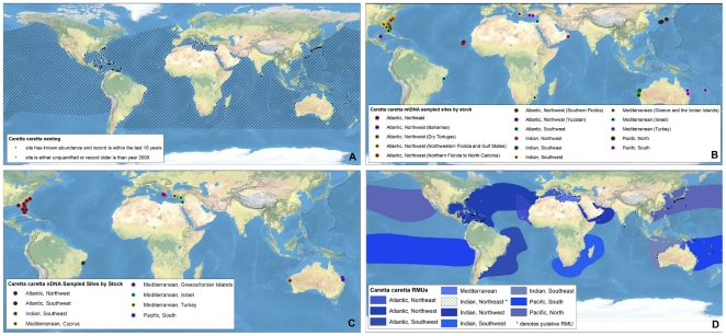
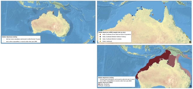
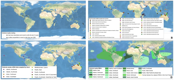
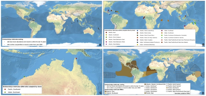
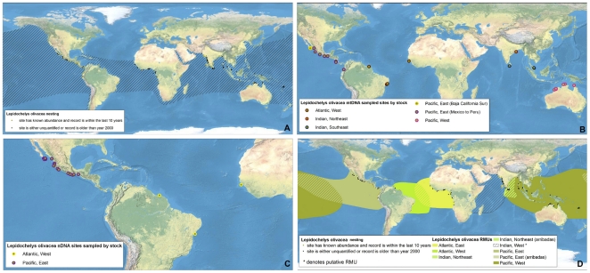
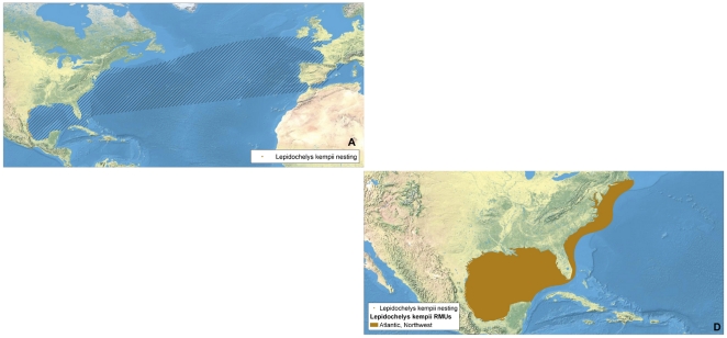
METHODOLOGY/PRINCIPAL FINDINGS: To address these issues for marine turtles, we collated all available studies on marine turtle biogeography, including nesting sites, population abundances and trends, population genetics, and satellite telemetry. We georeferenced this information to generate separate layers for nesting sites, genetic stocks, and core distributions of population segments of all marine turtle species. We then spatially integrated this information from fine- to coarse-spatial scales to develop nested envelope models, or Regional Management Units (RMUs), for marine turtles globally.
CONCLUSIONS/SIGNIFICANCE: The RMU framework is a solution to the challenge of how to organize marine turtles into units of protection above the level of nesting populations, but below the level of species, within regional entities that might be on independent evolutionary trajectories. Among many potential applications, RMUs provide a framework for identifying data gaps, assessing high diversity areas for multiple species and genetic stocks, and evaluating conservation status of marine turtles. Furthermore, RMUs allow for identification of geographic barriers to gene flow, and can provide valuable guidance to marine spatial planning initiatives that integrate spatial distributions of protected species and human activities. In addition, the RMU framework--including maps and supporting metadata--will be an iterative, user-driven tool made publicly available in an online application for comments, improvements, download and analysis.
解决广泛分布的海洋巨型动物所面临的威胁,需要明确威胁的地理分布以及感兴趣的种群单位。反过来,由于个别威胁可能在不同的空间尺度上运作,它们的影响可能会影响同一物种的不同种群段。因此,整合多种工具和技术,包括基于地点的监测、遗传分析、标记重捕研究和遥测,有助于在多个生物和空间尺度上对种群段进行稳健定义,以应对不同的管理和研究挑战。
方法/主要发现:为了解决海洋龟类的这些问题,我们整理了所有关于海洋龟类生物地理学的现有研究,包括筑巢地点、种群数量和趋势、种群遗传学和卫星遥测。我们将这些信息进行地理参考,为所有海洋龟类物种的筑巢地点、遗传种群和核心种群分布生成单独的图层。然后,我们从细到粗的空间尺度整合这些信息,为全球海洋龟类开发嵌套包络模型或区域管理单位 (RMU)。
结论/意义:RMU 框架是解决如何将海洋龟类组织成保护单位的挑战的解决方案,这些单位的保护级别高于筑巢种群,但低于物种,并且在可能处于独立进化轨迹的区域实体中。在许多潜在应用中,RMU 为确定数据空白、评估多个物种和遗传种群的高多样性区域以及评估海洋龟类的保护状况提供了框架。此外,RMU 允许识别基因流动的地理障碍,并为整合受保护物种和人类活动的空间分布的海洋空间规划倡议提供有价值的指导。此外,RMU 框架——包括地图和支持元数据——将是一个迭代的、用户驱动的工具,以在线应用程序的形式公开提供,供评论、改进、下载和分析。