University of Plymouth, Drake Circus, Plymouth, Devon, UK.
Int J Health Geogr. 2011 Dec 21;10:67. doi: 10.1186/1476-072X-10-67.
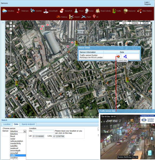
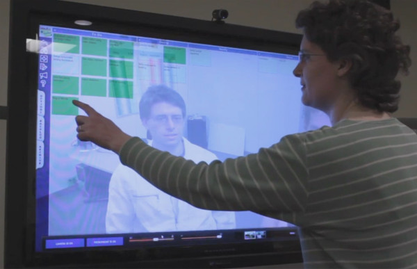
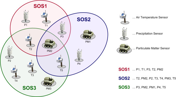
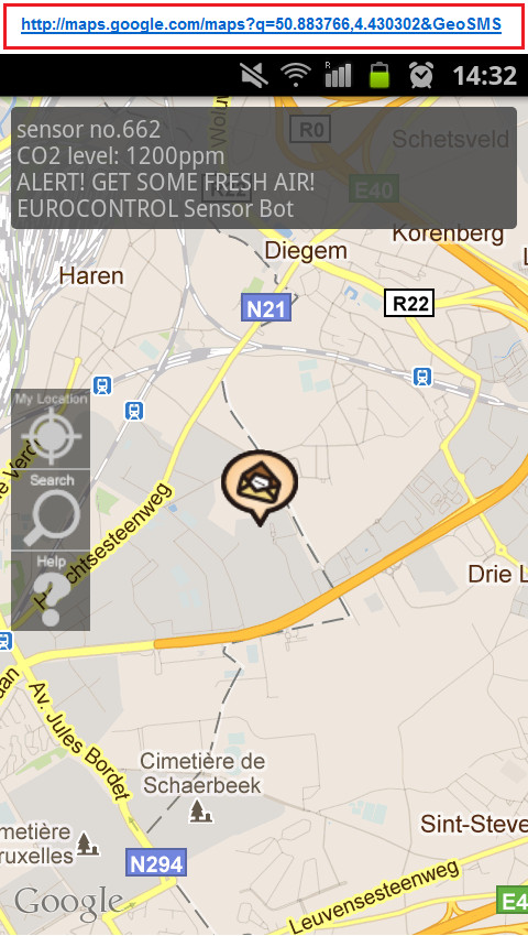
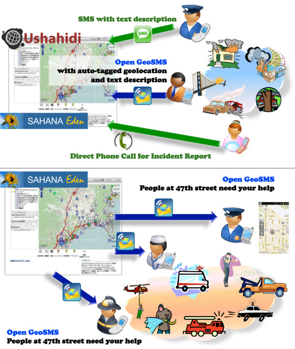
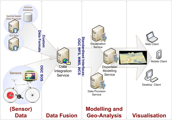
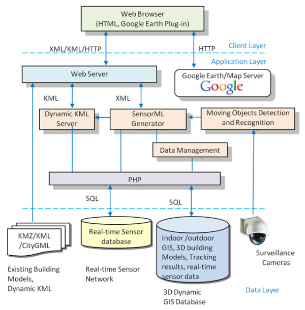
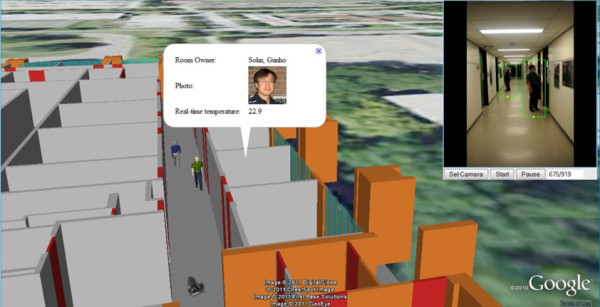
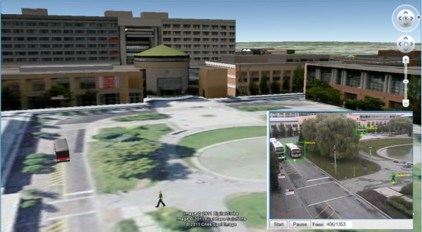
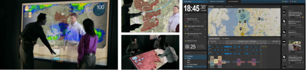
'Wikification of GIS by the masses' is a phrase-term first coined by Kamel Boulos in 2005, two years earlier than Goodchild's term 'Volunteered Geographic Information'. Six years later (2005-2011), OpenStreetMap and Google Earth (GE) are now full-fledged, crowdsourced 'Wikipedias of the Earth' par excellence, with millions of users contributing their own layers to GE, attaching photos, videos, notes and even 3-D (three dimensional) models to locations in GE. From using Twitter in participatory sensing and bicycle-mounted sensors in pervasive environmental sensing, to creating a 100,000-sensor geo-mashup using Semantic Web technology, to the 3-D visualisation of indoor and outdoor surveillance data in real-time and the development of next-generation, collaborative natural user interfaces that will power the spatially-enabled public health and emergency situation rooms of the future, where sensor data and citizen reports can be triaged and acted upon in real-time by distributed teams of professionals, this paper offers a comprehensive state-of-the-art review of the overlapping domains of the Sensor Web, citizen sensing and 'human-in-the-loop sensing' in the era of the Mobile and Social Web, and the roles these domains can play in environmental and public health surveillance and crisis/disaster informatics. We provide an in-depth review of the key issues and trends in these areas, the challenges faced when reasoning and making decisions with real-time crowdsourced data (such as issues of information overload, "noise", misinformation, bias and trust), the core technologies and Open Geospatial Consortium (OGC) standards involved (Sensor Web Enablement and Open GeoSMS), as well as a few outstanding project implementation examples from around the world.
“大众地理信息系统维基化”是一个词组术语,由卡迈勒·布卢斯于 2005 年首次提出,比古尔德柴尔德的术语“志愿地理信息”早两年。六年后(2005-2011 年),OpenStreetMap 和谷歌地球(GE)现在已经成为成熟的、众包的“地球维基百科”,数以百万计的用户在 GE 上贡献自己的图层,在 GE 中的位置上附加照片、视频、注释,甚至 3D(三维)模型。从使用 Twitter 进行参与式感知和自行车搭载传感器进行普遍环境感知,到使用语义网技术创建一个包含 10 万个传感器的地理混合应用程序,再到实时 3D 可视化室内和室外监控数据,以及开发下一代、协作式自然用户界面,这些界面将为未来具备空间能力的公共卫生和应急情况室提供动力,在这些情况室中,传感器数据和公民报告可以由分布式专业人员团队实时分类和处理,本文全面概述了传感器网络、公民感知和“人在回路感知”在移动和社交网络时代的重叠领域,以及这些领域在环境和公共卫生监测以及危机/灾害信息学中可以发挥的作用。我们深入回顾了这些领域的关键问题和趋势、在使用实时众包数据进行推理和决策时面临的挑战(如信息过载、“噪音”、错误信息、偏见和信任等问题)、涉及的核心技术和开放地理空间联盟(OGC)标准(传感器网络启用和开放地理短信服务),以及来自世界各地的一些杰出项目实施示例。