• 文献检索
  • 文档翻译
  • 深度研究
  • 学术资讯
  • Suppr Zotero 插件Zotero 插件
  • 邀请有礼
  • 套餐&价格
  • 历史记录
应用&插件
Suppr Zotero 插件Zotero 插件浏览器插件Mac 客户端Windows 客户端微信小程序
定价
高级版会员购买积分包购买API积分包
服务
文献检索文档翻译深度研究API 文档MCP 服务
关于我们
关于 Suppr公司介绍联系我们用户协议隐私条款
关注我们

Suppr 超能文献

核心技术专利:CN118964589B侵权必究
粤ICP备2023148730 号-1Suppr @ 2026

文献检索

告别复杂PubMed语法,用中文像聊天一样搜索,搜遍4000万医学文献。AI智能推荐,让科研检索更轻松。

立即免费搜索

文件翻译

保留排版,准确专业,支持PDF/Word/PPT等文件格式,支持 12+语言互译。

免费翻译文档

深度研究

AI帮你快速写综述,25分钟生成高质量综述,智能提取关键信息,辅助科研写作。

立即免费体验

利用 SeaWiFS 卫星数据记录开发沿海水质数值标准的方法。

An approach to developing numeric water quality criteria for coastal waters using the SeaWiFS Satellite Data Record.

机构信息

U.S. EPA National Health and Environmental Effects Research Laboratory, Gulf Ecology Division, 1 Sabine Island Drive, Gulf Breeze, Florida 32561, United States.

出版信息

Environ Sci Technol. 2012 Jan 17;46(2):916-22. doi: 10.1021/es2014105. Epub 2012 Jan 5.

DOI:10.1021/es2014105
PMID:22192062
原文链接:https://pmc.ncbi.nlm.nih.gov/articles/PMC3287117/
Abstract

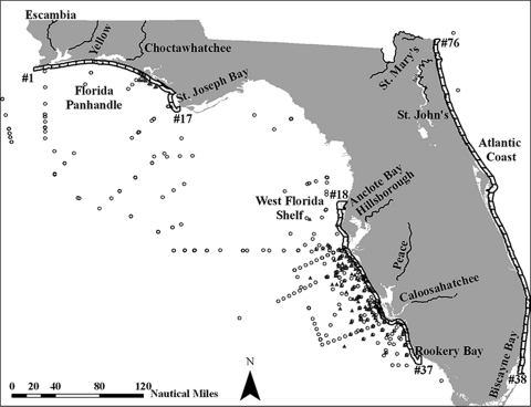
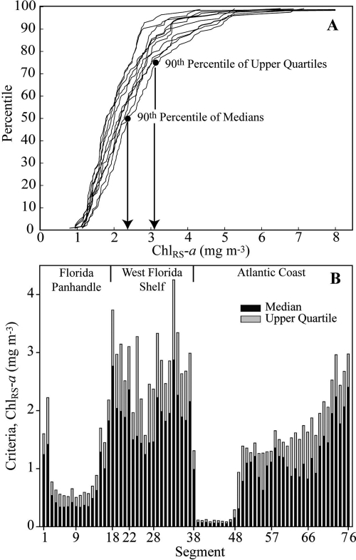
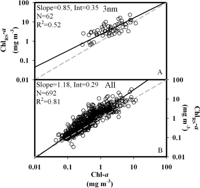
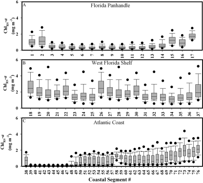
Human activities on land increase nutrient loads to coastal waters, which can increase phytoplankton production and biomass and associated ecological impacts. Numeric nutrient water quality standards are needed to protect coastal waters from eutrophication impacts. The Environmental Protection Agency determined that numeric nutrient criteria were necessary to protect designated uses of Florida's waters. The objective of this study was to evaluate a reference condition approach for developing numeric water quality criteria for coastal waters, using data from Florida. Florida's coastal waters have not been monitored comprehensively via field sampling to support numeric criteria development. However, satellite remote sensing had the potential to provide adequate data. Spatial and temporal measures of SeaWiFS OC4 chlorophyll-a (Chl(RS)-a, mg m(-3)) were resolved across Florida's coastal waters between 1997 and 2010 and compared with in situ measurements. Statistical distributions of Chl(RS)-a were evaluated to determine a quantitative reference baseline. A binomial approach was implemented to consider how new data could be assessed against the criteria. The proposed satellite remote sensing approach to derive numeric criteria may be generally applicable to other coastal waters.

摘要

人类在陆地上的活动增加了营养物质负荷到沿海水域,这可能会增加浮游植物的产量和生物量,并产生相关的生态影响。需要制定数值营养水质标准来防止沿海水域受到富营养化的影响。美国环境保护署认为,需要制定数值营养标准来保护佛罗里达州指定用途的水域。本研究的目的是评估一种参考条件方法,用于开发佛罗里达州沿海水域的数值水质标准,该方法使用了来自佛罗里达州的数据。佛罗里达州的沿海水域尚未通过现场采样进行全面监测,以支持数值标准的制定。然而,卫星遥感有可能提供足够的数据。在 1997 年至 2010 年期间,对佛罗里达州沿海海域的 SeaWiFS OC4 叶绿素-a(Chl(RS)-a,mg m(-3))进行了时空测量,并与现场测量进行了比较。评估了 Chl(RS)-a 的统计分布,以确定定量参考基线。实施了二项式方法来考虑如何根据标准评估新数据。该研究提出的基于卫星遥感的数值标准推导方法可能普遍适用于其他沿海海域。

https://cdn.ncbi.nlm.nih.gov/pmc/blobs/6772/3287117/5b38dafaf894/es-2011-014105_0004.jpg
https://cdn.ncbi.nlm.nih.gov/pmc/blobs/6772/3287117/b5e366c71759/es-2011-014105_0005.jpg
https://cdn.ncbi.nlm.nih.gov/pmc/blobs/6772/3287117/abde6330fedc/es-2011-014105_0006.jpg
https://cdn.ncbi.nlm.nih.gov/pmc/blobs/6772/3287117/9c8c6b578311/es-2011-014105_0003.jpg
https://cdn.ncbi.nlm.nih.gov/pmc/blobs/6772/3287117/5b38dafaf894/es-2011-014105_0004.jpg

相似文献

1
An approach to developing numeric water quality criteria for coastal waters using the SeaWiFS Satellite Data Record.利用 SeaWiFS 卫星数据记录开发沿海水质数值标准的方法。
Environ Sci Technol. 2012 Jan 17;46(2):916-22. doi: 10.1021/es2014105. Epub 2012 Jan 5.
2
Biogeochemical classification of South Florida's estuarine and coastal waters.南佛罗里达州河口和沿海水域的生物地球化学分类。
Mar Pollut Bull. 2013 Oct 15;75(1-2):187-204. doi: 10.1016/j.marpolbul.2013.07.034. Epub 2013 Aug 19.
3
Exploratory study of the Sentinel-3 level 2 product for monitoring chlorophyll-a and assessing ecological status in Danish seas.丹麦海域叶绿素-a 监测和生态状况评估的 Sentinel-3 二级产品探索性研究
Sci Total Environ. 2023 Nov 1;897:165310. doi: 10.1016/j.scitotenv.2023.165310. Epub 2023 Jul 6.
4
Maximizing the accuracy of field-derived numeric nutrient criteria in water quality regulations.最大限度地提高水质法规中现场推导的数值营养标准的准确性。
Integr Environ Assess Manag. 2014 Jan;10(1):133-7. doi: 10.1002/ieam.1485. Epub 2013 Dec 16.
5
Estimating the designated use attainment decision error rates of US Environmental Protection Agency's proposed numeric total phosphorus criteria for Florida, USA, colored lakes.估算美国环境保护署拟议的佛罗里达州彩色湖泊总磷标准指定用途达标决策错误率。
Integr Environ Assess Manag. 2012 Jan;8(1):167-74. doi: 10.1002/ieam.223. Epub 2011 Aug 24.
6
Modeling ocean surface chlorophyll-a concentration from ocean color remote sensing reflectance in global waters using machine learning.基于机器学习的全球水域海洋颜色遥感反射率反演海洋表面叶绿素 a 浓度模型。
Sci Total Environ. 2022 Oct 20;844:157191. doi: 10.1016/j.scitotenv.2022.157191. Epub 2022 Jul 8.
7
Diurnal remote sensing of coastal/oceanic waters: a radiometric analysis for Geostationary Coastal and Air Pollution Events.沿海/海洋水域的日间遥感:对地静止海岸与空气污染事件的辐射分析
Appl Opt. 2014 Feb 1;53(4):648-65. doi: 10.1364/AO.53.000648.
8
Bio-optical properties and ocean color algorithms for coastal waters influenced by the Mississippi River during a cold front.冷锋期间受密西西比河影响的沿海水域的生物光学特性及海洋颜色算法
Appl Opt. 2006 Oct 1;45(28):7410-28. doi: 10.1364/ao.45.007410.
9
A novel approach to model exposure of coastal-marine ecosystems to riverine flood plumes based on remote sensing techniques.基于遥感技术的沿海-海洋生态系统暴露于河流洪水羽流的新型建模方法。
J Environ Manage. 2013 Apr 15;119:194-207. doi: 10.1016/j.jenvman.2013.01.036. Epub 2013 Mar 22.
10
Assessment of trophic status of the northeastern Mediterranean coastal waters: eutrophication classification tools revisited.评估东北地中海沿海水域的营养状况:富营养化分类工具再探讨。
Environ Sci Pollut Res Int. 2019 May;26(15):14742-14754. doi: 10.1007/s11356-018-2529-6. Epub 2018 Jun 22.

引用本文的文献

1
Assessing potential of the Geostationary Littoral Imaging and Monitoring Radiometer (GLIMR) for water quality monitoring across the coastal United States.评估静止轨道沿海水域成像和监测辐射计(GLIMR)在美国沿海进行水质监测的潜力。
Mar Pollut Bull. 2023 Nov;196:115558. doi: 10.1016/j.marpolbul.2023.115558. Epub 2023 Sep 25.
2
Spatio-Temporal Dynamics of Inherent Optical Properties in Oligotrophic Northern Gulf of Mexico Estuaries.墨西哥湾北部贫营养河口固有光学特性的时空动态
Cont Shelf Res. 2018 Aug 15;166:92-107. doi: 10.1016/j.csr.2018.06.016.
3
Merging of the Case 2 Regional Coast Colour and Maximum-Peak Height chlorophyll-a algorithms: validation and demonstration of satellite-derived retrievals across US lakes.

本文引用的文献

1
Measurement of water colour using AVIRIS imagery to assess the potential for an operational monitoring capability in the Pamlico Sound Estuary, USA.利用机载可见红外成像光谱仪(AVIRIS)图像测量水色,以评估美国帕姆利科湾河口进行业务监测的潜力。
Int J Remote Sens. 2009 Jul;30(13-14):3291-3314. doi: 10.1080/01431160802552801. Epub 2009 Jul 22.
2
Inherent optical properties and satellite retrieval of chlorophyll concentration in the lagoon and open ocean waters of New Caledonia.新喀里多尼亚泻湖及开阔海域水体内生源光学特性及其叶绿素浓度卫星反演。
Mar Pollut Bull. 2010;61(7-12):503-18. doi: 10.1016/j.marpolbul.2010.06.039. Epub 2010 Aug 4.
3
案例 2 区域沿海颜色与最大峰值高度叶绿素-a 算法的融合:美国湖泊卫星反演验证与演示。
Environ Monit Assess. 2022 Feb 14;194(3):179. doi: 10.1007/s10661-021-09684-w.
4
Exploring the potential value of satellite remote sensing to monitor chlorophyll-a for US lakes and reservoirs.探索卫星遥感技术在美国湖泊和水库叶绿素-a监测中的潜在价值。
Environ Monit Assess. 2020 Dec 2;192(12):808. doi: 10.1007/s10661-020-08631-5.
5
Earth observations and integrative models in support of food and water security.支持粮食和水安全的地球观测与综合模型
Remote Sens Earth Syst Sci. 2019 Feb 11;2(1):18-38. doi: 10.1007/s41976-019-0008-6. Epub 2019 Mar 15.
6
Satellite monitoring of cyanobacterial harmful algal bloom frequency in recreational waters and drinking source waters.娱乐用水和饮用水源水中蓝藻有害藻华频率的卫星监测。
Ecol Indic. 2017 Sep;80:84-95. doi: 10.1016/j.ecolind.2017.04.046.
7
Novel Analyses of Long-Term Data Provide a Scientific Basis for Chlorophyll-a Thresholds in San Francisco Bay.长期数据的新分析为旧金山湾叶绿素a阈值提供了科学依据。
Estuar Coast Shelf Sci. 2017 Oct 15;197:107-118. doi: 10.1016/j.ecss.2017.07.009.
8
Quantifying seagrass light requirements using an algorithm to spatially resolve depth of colonization.使用一种算法对海草光照需求进行量化,以在空间上解析海草的定殖深度。
Estuaries Coast. 2018 Mar 1;41(2):592-610. doi: 10.1007/s12237-017-0287-1.
9
Satellite Remote Sensing for Coastal Management: A Review of Successful Applications.用于海岸管理的卫星遥感:成功应用综述
Environ Manage. 2017 Aug;60(2):323-339. doi: 10.1007/s00267-017-0880-x. Epub 2017 May 8.
10
Characterizing light attenuation within Northwest Florida Estuaries: Implications for RESTORE Act water quality monitoring.佛罗里达州西北部河口内光衰减特征:对《恢复法案》水质监测的影响
Mar Pollut Bull. 2017 Jan 30;114(2):995-1006. doi: 10.1016/j.marpolbul.2016.11.030. Epub 2016 Nov 19.
Harmful algal blooms and eutrophication: Examining linkages from selected coastal regions of the United States.
有害藻华与富营养化:审视美国部分沿海地区的联系
Harmful Algae. 2008 Dec 1;8(1):39-53. doi: 10.1016/j.hal.2008.08.017.