Tanskanen Antti, Nillos Leilani T, Lehtinen Antti, Nohynek Hanna, Sanvictores Diozele Hazel M, Simões Eric Af, Tallo Veronica L, Lucero Marilla G
Research Institute for Tropical Medicine, Muntinlupa City, Philippines.
BMC Res Notes. 2012 Jan 20;5:51. doi: 10.1186/1756-0500-5-51.
The goal of this Geographic Information System (GIS) study was to obtain accurate information on the locations of study subjects, road network and services for research purposes so that the clinical outcomes of interest (e.g., vaccine efficacy, burden of disease, nasopharyngeal colonization and its reduction) could be linked and analyzed at a distance from health centers, hospitals, doctors and other important services. The information on locations can be used to investigate more accurate crowdedness, herd immunity and/or transmission patterns.
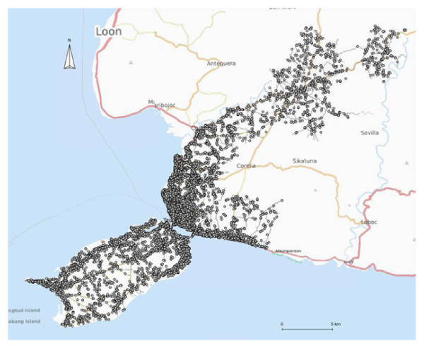
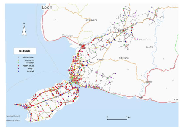
A randomized, placebo-controlled, double-blind trial of an 11-valent pneumococcal conjugate vaccine (11PCV) was conducted in Bohol Province in central Philippines, from July 2000 to December 2004. We collected the information on the geographic location of the households (N = 13,208) of study subjects. We also collected a total of 1982 locations of health and other services in the six municipalities and a comprehensive GIS data over the road network in the area.
We calculated the numbers of other study subjects (vaccine and placebo recipients, respectively) within the neighborhood of each study subject. We calculated distances to different services and identified the subjects sharing the same services (calculated by distance). This article shows how to collect a complete GIS data set for human to human transmitted vaccine study in developing country settings in an efficient and economical way.
The collection of geographic locations in intervention trials should become a routine task. The results of public health research may highly depend on spatial relationships among the study subjects and between the study subjects and the environment, both natural and infrastructural.
ISRCTN: ISRCTN62323832.
本地理信息系统(GIS)研究的目的是获取研究对象的位置、道路网络和服务的准确信息,用于研究目的,以便能够在远离健康中心、医院、医生和其他重要服务的地方关联和分析感兴趣的临床结果(如疫苗效力、疾病负担、鼻咽部定植及其减少情况)。位置信息可用于调查更准确的拥挤程度、群体免疫和/或传播模式。
2000年7月至2004年12月,在菲律宾中部的薄荷省进行了一项11价肺炎球菌结合疫苗(11PCV)的随机、安慰剂对照、双盲试验。我们收集了研究对象家庭(N = 13208)的地理位置信息。我们还收集了六个市镇中1982个健康及其他服务场所的位置信息,以及该地区道路网络的全面GIS数据。
我们计算了每个研究对象周边其他研究对象(分别为疫苗接种者和安慰剂接受者)的数量。我们计算了到不同服务场所的距离,并确定了共享相同服务场所的对象(按距离计算)。本文展示了如何以高效且经济的方式为发展中国家环境下的人际传播疫苗研究收集完整的GIS数据集。
在干预试验中收集地理位置信息应成为一项常规任务。公共卫生研究的结果可能高度依赖于研究对象之间以及研究对象与自然和基础设施环境之间的空间关系。
ISRCTN:ISRCTN62323832。