Brakebill Jw, Wolock Dm, Terziotti Se
J Am Water Resour Assoc. 2011 Oct;47(5):916-932. doi: 10.1111/j.1752-1688.2011.00578.x.
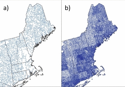
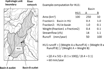
Digital hydrologic networks depicting surface-water pathways and their associated drainage catchments provide a key component to hydrologic analysis and modeling. Collectively, they form common spatial units that can be used to frame the descriptions of aquatic and watershed processes. In addition, they provide the ability to simulate and route the movement of water and associated constituents throughout the landscape. Digital hydrologic networks have evolved from derivatives of mapping products to detailed, interconnected, spatially referenced networks of water pathways, drainage areas, and stream and watershed characteristics. These properties are important because they enhance the ability to spatially evaluate factors that affect the sources and transport of water-quality constituents at various scales. SPAtially Referenced Regressions On Watershed attributes (SPARROW), a process-based/statistical model, relies on a digital hydrologic network in order to establish relations between quantities of monitored contaminant flux, contaminant sources, and the associated physical characteristics affecting contaminant transport. Digital hydrologic networks modified from the River Reach File (RF1) and National Hydrography Dataset (NHD) geospatial datasets provided frameworks for SPARROW in six regions of the conterminous United States. In addition, characteristics of the modified RF1 were used to update estimates of mean-annual streamflow. This produced more current flow estimates for use in SPARROW modeling.
描绘地表水路径及其相关排水集水区的数字水文网络是水文分析和建模的关键组成部分。它们共同构成了可用于构建水生和流域过程描述的通用空间单元。此外,它们还具备模拟和确定水及相关成分在整个景观中流动路径的能力。数字水文网络已从地图产品的衍生形式发展成为详细的、相互连接的、具有空间参考的水路径、排水区域以及溪流和流域特征网络。这些特性很重要,因为它们增强了在不同尺度上对影响水质成分来源和传输的因素进行空间评估的能力。基于过程/统计模型的流域属性空间参考回归(SPARROW)依赖数字水文网络来建立监测到的污染物通量数量、污染物来源以及影响污染物传输的相关物理特征之间的关系。从河流河段文件(RF1)和国家水文数据集(NHD)地理空间数据集中修改而来的数字水文网络为美国本土六个地区的SPARROW提供了框架。此外,修改后的RF1的特征被用于更新年均流量估计值。这为SPARROW建模提供了更及时的流量估计值。