Department of Geography, Simon Fraser University, 8888 University Dr, Burnaby, BC, V5A 1S6, Canada.
BMC Health Serv Res. 2012 Aug 1;12:230. doi: 10.1186/1472-6963-12-230.
Primary health care (PHC) encompasses an array of health and social services that focus on preventative, diagnostic, and basic care measures to maintain wellbeing and address illnesses. In Canada, PHC involves the provision of first-contact health care services by providers such as family physicians and general practitioners - collectively referred as PHC physicians here. Ensuring access is a key requirement of effective PHC delivery. This is because having access to PHC has been shown to positively impact a number of health outcomes.
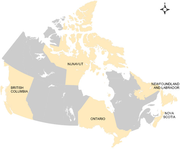
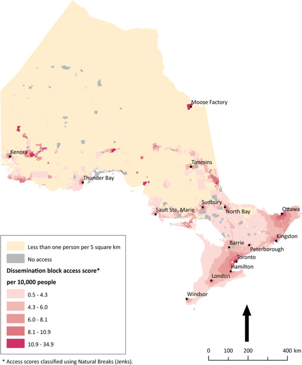
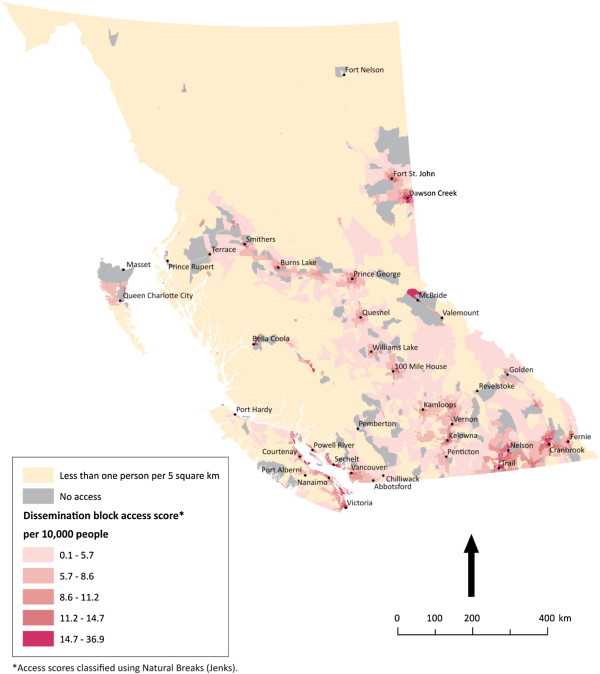
We build on recent innovations in measuring potential spatial access to PHC physicians using geographic information systems (GIS) by running and then interpreting the findings of a modified gravity model. Elsewhere we have introduced the protocol for this model. In this article we run it for five selected Canadian provinces and territories. Our objectives are to present the results of the modified gravity model in order to: (1) understand how potential spatial access to PHC physicians can be interpreted in these Canadian jurisdictions, and (2) provide guidance regarding how findings of the modified gravity model should be interpreted in other analyses.
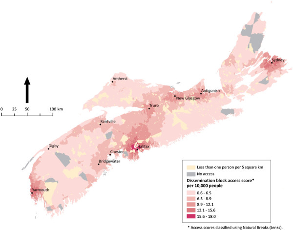
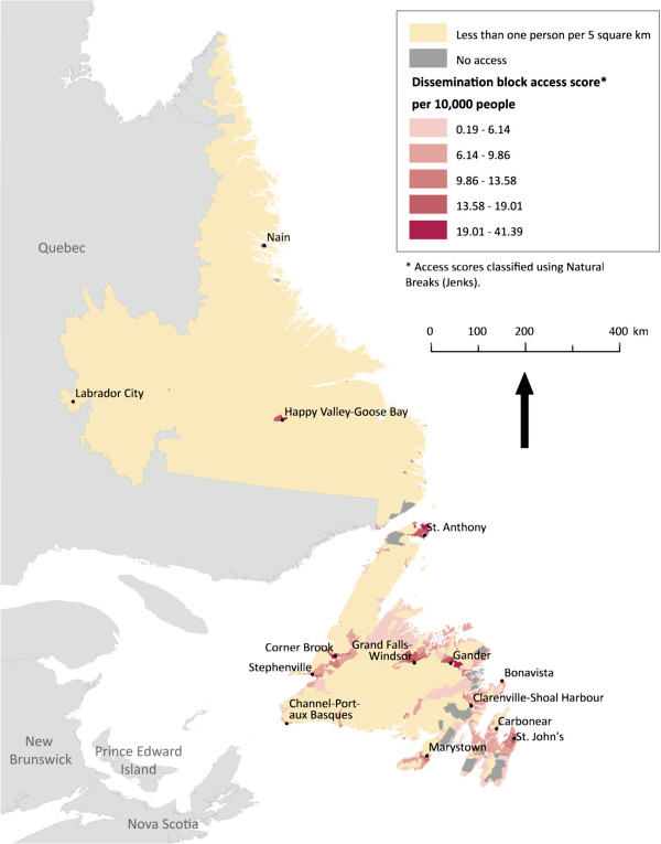
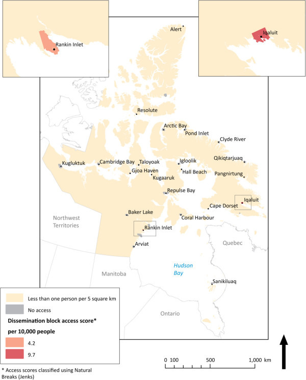
Regarding the first objective, two distinct spatial patterns emerge regarding potential spatial access to PHC physicians in the five selected Canadian provinces: (1) a clear north-south pattern, where southern areas have greater potential spatial access than northern areas; and (2) while gradients of potential spatial access exist in and around urban areas, access outside of densely-to-moderately populated areas is fairly binary. Regarding the second objective, we identify three principles that others can use to interpret the findings of the modified gravity model when used in other research contexts.
Future applications of the modified gravity model are needed in order to refine the recommendations we provide on interpreting its results. It is important that studies are undertaken that can help administrators, policy-makers, researchers, and others with characterizing the state of access to PHC, including potential spatial access. We encourage further research to be done using GIS in order to offer new, spatial perspectives on issues of access to health services given the increased recognition that the place-based nature of health services can benefit from the use of the capabilities of GIS to enhance the role that visualization plays in decision-making.
初级卫生保健(PHC)涵盖了一系列的卫生和社会服务,侧重于预防、诊断和基本护理措施,以维护健康和治疗疾病。在加拿大,PHC 涉及家庭医生和全科医生等提供者提供的首次接触式医疗服务——在这里统称为 PHC 医生。确保获得医疗服务是有效提供 PHC 的关键要求。这是因为获得 PHC 已被证明对许多健康结果产生积极影响。
我们利用地理信息系统(GIS)最近在衡量潜在的 PHC 医生空间可达性方面的创新,运行并解释修正后的重力模型的结果。在其他地方,我们已经介绍了该模型的协议。在本文中,我们在五个选定的加拿大省份和地区运行该模型。我们的目标是展示修正后的重力模型的结果,以便:(1)了解在这些加拿大司法管辖区中如何解释 PHC 医生的潜在空间可达性,以及(2)提供有关如何解释其他分析中修正后的重力模型结果的指导。
关于第一个目标,在五个选定的加拿大省份中,PHC 医生的潜在空间可达性呈现出两种截然不同的空间模式:(1)明显的南北模式,南部地区的潜在空间可达性大于北部地区;(2)虽然城市地区及其周围存在潜在空间可达性梯度,但人口稠密至中等密度地区以外的可达性相当二元。关于第二个目标,我们确定了其他人在其他研究背景下解释修正后的重力模型结果时可以使用的三个原则。
需要进一步应用修正后的重力模型,以完善我们关于解释其结果的建议。重要的是要进行研究,以帮助管理人员、政策制定者、研究人员和其他人了解 PHC 获得情况,包括潜在的空间可达性。我们鼓励使用 GIS 进行进一步研究,以便为医疗服务获得问题提供新的空间视角,因为人们越来越认识到卫生服务的基于位置的性质可以受益于使用 GIS 的功能来增强可视化在决策中的作用。