• 文献检索
  • 文档翻译
  • 深度研究
  • 学术资讯
  • Suppr Zotero 插件Zotero 插件
  • 邀请有礼
  • 套餐&价格
  • 历史记录
应用&插件
Suppr Zotero 插件Zotero 插件浏览器插件Mac 客户端Windows 客户端微信小程序
定价
高级版会员购买积分包购买API积分包
服务
文献检索文档翻译深度研究API 文档MCP 服务
关于我们
关于 Suppr公司介绍联系我们用户协议隐私条款
关注我们

Suppr 超能文献

核心技术专利:CN118964589B侵权必究
粤ICP备2023148730 号-1Suppr @ 2026

文献检索

告别复杂PubMed语法,用中文像聊天一样搜索,搜遍4000万医学文献。AI智能推荐,让科研检索更轻松。

立即免费搜索

文件翻译

保留排版,准确专业,支持PDF/Word/PPT等文件格式,支持 12+语言互译。

免费翻译文档

深度研究

AI帮你快速写综述,25分钟生成高质量综述,智能提取关键信息,辅助科研写作。

立即免费体验

利用随机森林结合超高分辨率卫星图像和地形建模来绘制亚南极垫状植物图。

Mapping sub-antarctic cushion plants using random forests to combine very high resolution satellite imagery and terrain modelling.

机构信息

School of Geography and Environmental Studies, University of Tasmania, Hobart, Tasmania, Australia.

出版信息

PLoS One. 2013 Aug 5;8(8):e72093. doi: 10.1371/journal.pone.0072093. Print 2013.

DOI:10.1371/journal.pone.0072093
PMID:23940805
原文链接:https://pmc.ncbi.nlm.nih.gov/articles/PMC3733920/
Abstract

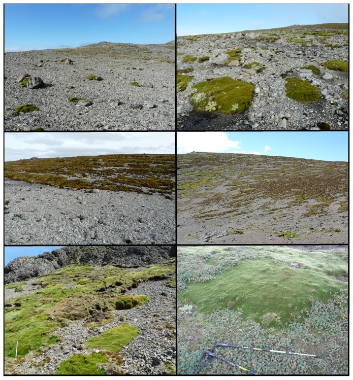
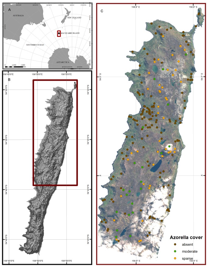
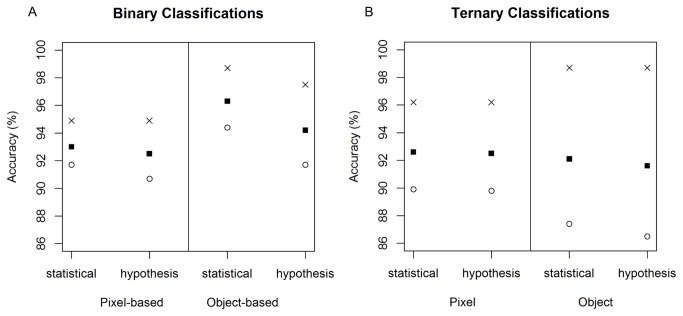
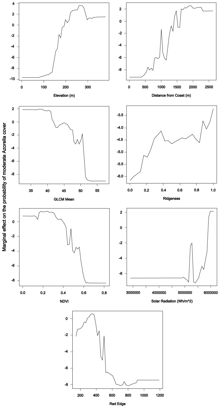
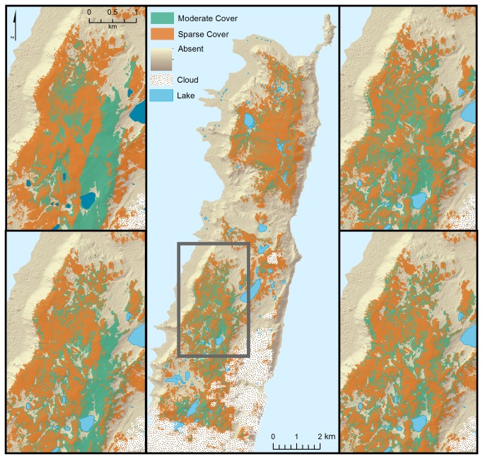
Monitoring changes in the distribution and density of plant species often requires accurate and high-resolution baseline maps of those species. Detecting such change at the landscape scale is often problematic, particularly in remote areas. We examine a new technique to improve accuracy and objectivity in mapping vegetation, combining species distribution modelling and satellite image classification on a remote sub-Antarctic island. In this study, we combine spectral data from very high resolution WorldView-2 satellite imagery and terrain variables from a high resolution digital elevation model to improve mapping accuracy, in both pixel- and object-based classifications. Random forest classification was used to explore the effectiveness of these approaches on mapping the distribution of the critically endangered cushion plant Azorella macquariensis Orchard (Apiaceae) on sub-Antarctic Macquarie Island. Both pixel- and object-based classifications of the distribution of Azorella achieved very high overall validation accuracies (91.6-96.3%, κ = 0.849-0.924). Both two-class and three-class classifications were able to accurately and consistently identify the areas where Azorella was absent, indicating that these maps provide a suitable baseline for monitoring expected change in the distribution of the cushion plants. Detecting such change is critical given the threats this species is currently facing under altering environmental conditions. The method presented here has applications to monitoring a range of species, particularly in remote and isolated environments.

摘要

监测植物物种分布和密度的变化通常需要这些物种的准确和高分辨率的基线地图。在景观尺度上检测这种变化通常是有问题的,尤其是在偏远地区。我们研究了一种新的技术,以提高在偏远的亚南极岛屿上绘制植被图的准确性和客观性。在这项研究中,我们将高分辨率数字高程模型中的地形变量与高分辨率 WorldView-2 卫星图像的光谱数据相结合,以提高像素和基于对象的分类中的制图精度。随机森林分类用于探索这些方法在绘制极度濒危垫状植物 Azorella macquariensis Orchard(伞形科)在亚南极麦夸里岛的分布上的有效性。Azorella 分布的基于像素和基于对象的分类都达到了非常高的总体验证精度(91.6-96.3%,κ=0.849-0.924)。两分类和三分类都能够准确一致地识别出 Azorella 不存在的区域,这表明这些地图为监测垫状植物分布的预期变化提供了合适的基线。鉴于该物种目前在不断变化的环境条件下面临的威胁,检测这种变化至关重要。这里提出的方法适用于监测一系列物种,特别是在偏远和孤立的环境中。

https://cdn.ncbi.nlm.nih.gov/pmc/blobs/8b6c/3733920/6df28396ff13/pone.0072093.g007.jpg
https://cdn.ncbi.nlm.nih.gov/pmc/blobs/8b6c/3733920/6a67aecec520/pone.0072093.g001.jpg
https://cdn.ncbi.nlm.nih.gov/pmc/blobs/8b6c/3733920/27f814b1753a/pone.0072093.g002.jpg
https://cdn.ncbi.nlm.nih.gov/pmc/blobs/8b6c/3733920/ea0dc7dcf6ae/pone.0072093.g003.jpg
https://cdn.ncbi.nlm.nih.gov/pmc/blobs/8b6c/3733920/e6ae8852a060/pone.0072093.g004.jpg
https://cdn.ncbi.nlm.nih.gov/pmc/blobs/8b6c/3733920/a412fba50ca1/pone.0072093.g005.jpg
https://cdn.ncbi.nlm.nih.gov/pmc/blobs/8b6c/3733920/188a6794f826/pone.0072093.g006.jpg
https://cdn.ncbi.nlm.nih.gov/pmc/blobs/8b6c/3733920/6df28396ff13/pone.0072093.g007.jpg

相似文献

1
Mapping sub-antarctic cushion plants using random forests to combine very high resolution satellite imagery and terrain modelling.利用随机森林结合超高分辨率卫星图像和地形建模来绘制亚南极垫状植物图。
PLoS One. 2013 Aug 5;8(8):e72093. doi: 10.1371/journal.pone.0072093. Print 2013.
2
Monitoring recent changes of vegetation in Fildes Peninsula (King George Island, Antarctica) through satellite imagery guided by UAV surveys.利用无人机调查指导的卫星图像监测费尔德斯半岛(乔治王岛,南极洲)的植被近期变化。
Sci Total Environ. 2020 Feb 20;704:135295. doi: 10.1016/j.scitotenv.2019.135295. Epub 2019 Nov 25.
3
A hyper-temporal remote sensing protocol for high-resolution mapping of ecological sites.一种用于生态站点高分辨率制图的超时间遥感协议。
PLoS One. 2017 Apr 17;12(4):e0175201. doi: 10.1371/journal.pone.0175201. eCollection 2017.
4
The influence of landscape, climate and history on spatial genetic patterns in keystone plants (Azorella) on sub-Antarctic islands.景观、气候和历史对亚南极岛屿关键植物(阿祖雷拉)空间遗传模式的影响。
Mol Ecol. 2019 Jul;28(14):3291-3305. doi: 10.1111/mec.15147. Epub 2019 Jul 10.
5
Estimation of woody plant species diversity during a dry season in a savanna environment using the spectral and textural information derived from WorldView-2 imagery.利用 WorldView-2 影像提取的光谱和纹理信息估算热带稀树草原环境中旱季木本植物物种多样性。
PLoS One. 2020 Jun 8;15(6):e0234158. doi: 10.1371/journal.pone.0234158. eCollection 2020.
6
Automated satellite remote sensing of giant kelp at the Falkland Islands (Islas Malvinas).福克兰群岛(马尔维纳斯群岛)大型褐藻的自动化卫星遥感。
PLoS One. 2022 Jan 6;17(1):e0257933. doi: 10.1371/journal.pone.0257933. eCollection 2022.
7
Assessment of Acacia koa forest health across environmental gradients in Hawai'i using fine resolution remote sensing and GIS.利用高分辨率遥感和 GIS 评估夏威夷科阿相思树森林在不同环境梯度下的健康状况。
Sensors (Basel). 2011;11(6):5677-94. doi: 10.3390/s110605677. Epub 2011 May 27.
8
Mapping of the corals around Hendorabi Island (Persian Gulf), using WorldView-2 standard imagery coupled with field observations.利用 WorldView-2 标准影像并结合实地观测,对亨多拉比岛(波斯湾)周围的珊瑚进行绘制。
Mar Pollut Bull. 2018 Apr;129(1):266-274. doi: 10.1016/j.marpolbul.2018.02.045. Epub 2018 Mar 23.
9
Monitoring forest dynamics with multi-scale and time series imagery.利用多尺度和时间序列影像监测森林动态。
Environ Monit Assess. 2016 May;188(5):273. doi: 10.1007/s10661-016-5271-x. Epub 2016 Apr 8.
10
Land use and land cover (LULC) of the Republic of the Maldives: first national map and LULC change analysis using remote-sensing data.马尔代夫共和国的土地利用与土地覆盖(LULC):首张全国地图及利用遥感数据进行的土地利用与土地覆盖变化分析
Environ Monit Assess. 2017 Aug;189(8):417. doi: 10.1007/s10661-017-6120-2. Epub 2017 Jul 26.

引用本文的文献

1
A Novel Invertebrate Predator on an Oceanic Island: Impacts and Invasion Dynamics of on Macquarie Island.海洋岛屿上的一种新型无脊椎捕食者:麦夸里岛上[具体物种名称未给出]的影响与入侵动态
Ecol Evol. 2025 Jul 1;15(7):e71663. doi: 10.1002/ece3.71663. eCollection 2025 Jul.
2
Can vegetation be discretely classified in species-poor environments? Testing plant community concepts for vegetation monitoring on sub-Antarctic Marion Island.在物种贫乏的环境中能否对植被进行离散分类?在亚南极马里恩岛测试用于植被监测的植物群落概念。
Ecol Evol. 2023 Jan 3;13(1):e9681. doi: 10.1002/ece3.9681. eCollection 2023 Jan.
3
Land use and land cover changes along the China-Myanmar Oil and Gas pipelines - Monitoring infrastructure development in remote conflict-prone regions.

本文引用的文献

1
Geographic Object-Based Image Analysis - Towards a new paradigm.基于地理对象的图像分析——迈向新范式。
ISPRS J Photogramm Remote Sens. 2014 Jan;87(100):180-191. doi: 10.1016/j.isprsjprs.2013.09.014.
2
Ensemble habitat mapping of invasive plant species.入侵植物物种的综合生境制图。
Risk Anal. 2010 Feb;30(2):224-35. doi: 10.1111/j.1539-6924.2009.01343.x. Epub 2010 Feb 2.
3
Random forests for classification in ecology.用于生态学分类的随机森林
中缅油气管道沿线土地利用/土地覆被变化——监测偏远冲突多发地区基础设施的发展。
PLoS One. 2020 Aug 19;15(8):e0237806. doi: 10.1371/journal.pone.0237806. eCollection 2020.
4
Proximate cues to phases of movement in a highly dispersive waterfowl, Anas superciliosa.高度分散的水禽——赤颈鸭(Anas superciliosa)运动阶段的近距线索。
Mov Ecol. 2015 Sep 1;3(1):21. doi: 10.1186/s40462-015-0048-3. eCollection 2015.
5
Easy Come, Easy Go: Capillary Forces Enable Rapid Refilling of Embolized Primary Xylem Vessels.来得容易,去得快:毛细作用力促使栓塞的初生木质部导管快速再充盈。
Plant Physiol. 2015 Aug;168(4):1636-47. doi: 10.1104/pp.15.00333. Epub 2015 Jun 19.
Ecology. 2007 Nov;88(11):2783-92. doi: 10.1890/07-0539.1.