• 文献检索
  • 文档翻译
  • 深度研究
  • 学术资讯
  • Suppr Zotero 插件Zotero 插件
  • 邀请有礼
  • 套餐&价格
  • 历史记录
应用&插件
Suppr Zotero 插件Zotero 插件浏览器插件Mac 客户端Windows 客户端微信小程序
定价
高级版会员购买积分包购买API积分包
服务
文献检索文档翻译深度研究API 文档MCP 服务
关于我们
关于 Suppr公司介绍联系我们用户协议隐私条款
关注我们

Suppr 超能文献

核心技术专利:CN118964589B侵权必究
粤ICP备2023148730 号-1Suppr @ 2026

文献检索

告别复杂PubMed语法,用中文像聊天一样搜索,搜遍4000万医学文献。AI智能推荐,让科研检索更轻松。

立即免费搜索

文件翻译

保留排版,准确专业,支持PDF/Word/PPT等文件格式,支持 12+语言互译。

免费翻译文档

深度研究

AI帮你快速写综述,25分钟生成高质量综述,智能提取关键信息,辅助科研写作。

立即免费体验

marmap:一个用于在 R 中导入、绘制和分析水深和地形数据的软件包。

marmap: A package for importing, plotting and analyzing bathymetric and topographic data in R.

机构信息

Littoral, Environnement et Sociétés Joint Research Unit 7266 Centre National de la Recherche Scientifique, Université de La Rochelle, La Rochelle, France.

出版信息

PLoS One. 2013 Sep 3;8(9):e73051. doi: 10.1371/journal.pone.0073051. eCollection 2013.

DOI:10.1371/journal.pone.0073051
PMID:24019892
原文链接:https://pmc.ncbi.nlm.nih.gov/articles/PMC3760912/
Abstract

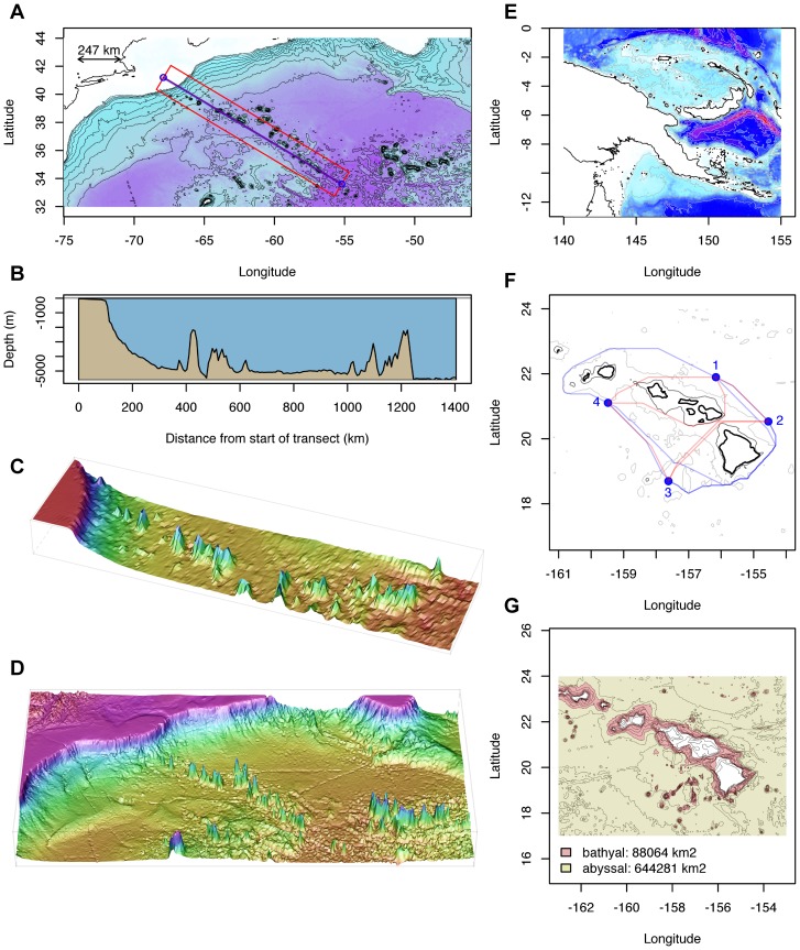
In this communication we introduce marmap, a package designed for downloading, plotting and manipulating bathymetric and topographic data in R. marmap can query the ETOPO1 bathymetry and topography database hosted by the NOAA, use simple latitude-longitude-depth data in ascii format, and take advantage of the advanced plotting tools available in R to build publication-quality bathymetric maps. Functions to query data (bathymetry, sampling information…) are available interactively by clicking on marmap maps. Bathymetric and topographic data can also be used to calculate projected surface areas within specified depth/altitude intervals, and constrain the calculation of realistic shortest path distances. Such information can be used in molecular ecology, for example, to evaluate genetic isolation by distance in a spatially-explicit framework.

摘要

在本通讯中,我们介绍了 marmap 包,它是一个用于在 R 中下载、绘制和操作水深和地形数据的工具。marmap 可以查询由美国国家海洋和大气管理局(NOAA)托管的 ETOPO1 水深和地形数据库,使用 ASCII 格式的简单经纬度深度数据,并利用 R 中提供的高级绘图工具来构建出版质量的水深图。通过点击 marmap 地图,可以交互地查询数据(水深、采样信息等)。水深和地形数据还可用于计算指定深度/海拔间隔内的投影表面积,并限制计算实际的最短路径距离。这种信息可用于分子生态学,例如,在空间显式框架中评估遗传距离隔离。

https://cdn.ncbi.nlm.nih.gov/pmc/blobs/2a6b/3760912/a3ce49569def/pone.0073051.g002.jpg
https://cdn.ncbi.nlm.nih.gov/pmc/blobs/2a6b/3760912/0f03a3e278b3/pone.0073051.g001.jpg
https://cdn.ncbi.nlm.nih.gov/pmc/blobs/2a6b/3760912/a3ce49569def/pone.0073051.g002.jpg
https://cdn.ncbi.nlm.nih.gov/pmc/blobs/2a6b/3760912/0f03a3e278b3/pone.0073051.g001.jpg
https://cdn.ncbi.nlm.nih.gov/pmc/blobs/2a6b/3760912/a3ce49569def/pone.0073051.g002.jpg

相似文献

1
marmap: A package for importing, plotting and analyzing bathymetric and topographic data in R.marmap:一个用于在 R 中导入、绘制和分析水深和地形数据的软件包。
PLoS One. 2013 Sep 3;8(9):e73051. doi: 10.1371/journal.pone.0073051. eCollection 2013.
2
Evaluation of the Accuracy of Bathymetry on the Nearshore Coastlines of Western Korea from Satellite Altimetry, Multi-Beam, and Airborne Bathymetric LiDAR.基于卫星测高、多波束和机载测深激光雷达评估朝鲜西部近岸海域水深测量精度。
Sensors (Basel). 2018 Sep 3;18(9):2926. doi: 10.3390/s18092926.
3
An R-based integrated method for producing river bathymetry and cross-sections from recreational-grade sonar sensor data.一种基于R语言的综合方法,用于从娱乐级声纳传感器数据生成河道测深图和横断面图。
MethodsX. 2024 Jul 6;13:102852. doi: 10.1016/j.mex.2024.102852. eCollection 2024 Dec.
4
Improved Bathymetric Mapping of Coastal and Lake Environments Using Sentinel-2 and Landsat-8 Images.利用哨兵-2和陆地卫星-8影像改进沿海和湖泊环境的水深测绘
Sensors (Basel). 2019 Jun 21;19(12):2788. doi: 10.3390/s19122788.
5
Satellite-derived bathymetry integrating spatial and spectral information of multispectral images.基于多光谱图像空间和光谱信息的卫星测深。
Appl Opt. 2023 Mar 10;62(8):2017-2029. doi: 10.1364/AO.480698.
6
Multibeam bathymetry data of discovery gap in the eastern North Atlantic.北大西洋东部发现间隙的多波束测深数据。
Data Brief. 2020 May 13;31:105679. doi: 10.1016/j.dib.2020.105679. eCollection 2020 Aug.
7
GLOBathy, the global lakes bathymetry dataset.GLOBathy,全球湖泊水深数据集。
Sci Data. 2022 Feb 3;9(1):36. doi: 10.1038/s41597-022-01132-9.
8
Generating higher resolution regional seafloor maps from crowd-sourced bathymetry.利用众包水深数据生成更高分辨率的区域海底地图。
PLoS One. 2019 Jun 10;14(6):e0216792. doi: 10.1371/journal.pone.0216792. eCollection 2019.
9
Durga: an R package for effect size estimation and visualization.Durga:用于效应量估计和可视化的 R 包。
J Evol Biol. 2024 Aug 1;37(8):986-993. doi: 10.1093/jeb/voae073.
10
Processing of Bathymetric Data: The Fusion of New Reduction Methods for Spatial Big Data.测深数据处理:空间大数据新归约方法的融合
Sensors (Basel). 2020 Oct 30;20(21):6207. doi: 10.3390/s20216207.

引用本文的文献

1
Population Genomics Reveals Panmixia in Pacific Sardine () of the North Pacific.群体基因组学揭示了北太平洋太平洋沙丁鱼()的随机交配。
Evol Appl. 2025 Sep 4;18(9):e70154. doi: 10.1111/eva.70154. eCollection 2025 Sep.
2
Deep-sea-floor diversity in Asteroidea is shaped by competing processes across different latitudes and oceans.海星纲在深海海底的多样性是由不同纬度和海洋中相互竞争的过程塑造的。
Nat Ecol Evol. 2025 Aug 8. doi: 10.1038/s41559-025-02808-2.
3
Penguins exploit tidal currents for efficient navigation and opportunistic foraging.

本文引用的文献

1
Spatial inference of admixture proportions and secondary contact zones.混合比例和二次接触带的空间推断。
Mol Biol Evol. 2009 Sep;26(9):1963-73. doi: 10.1093/molbev/msp106. Epub 2009 May 21.
企鹅利用潮流进行高效导航和机会主义觅食。
PLoS Biol. 2025 Jul 17;23(7):e3002981. doi: 10.1371/journal.pbio.3002981. eCollection 2025 Jul.
4
Killer whale call detection rates vary among subspecies and populations in the North Pacific.在北太平洋,虎鲸叫声的检测率因亚种和种群而异。
Sci Rep. 2025 Jul 1;15(1):21072. doi: 10.1038/s41598-025-06041-6.
5
Drivers of genetic diversity across the marine tree of life.海洋生命树中遗传多样性的驱动因素。
bioRxiv. 2025 Jun 6:2025.06.03.657718. doi: 10.1101/2025.06.03.657718.
6
Elevated fish growth yet postponed maturation during intense marine heatwaves.在强烈的海洋热浪期间鱼类生长加快但成熟推迟。
Ecol Appl. 2025 Jun;35(4):e70033. doi: 10.1002/eap.70033.
7
f-statistics-based ancestry profiling and convolutional neural network phenotyping shed new light on the structure of genetic and spike shape diversity in Aegilops tauschii Coss.基于F统计量的祖先分析和卷积神经网络表型分析为节节麦(Aegilops tauschii Coss.)的遗传结构和穗形态多样性带来了新的认识。
Proc Jpn Acad Ser B Phys Biol Sci. 2025 Jun 11;101(6):357-370. doi: 10.2183/pjab.101.023. Epub 2025 May 21.
8
Leveraging Whole Genomes, Mitochondrial DNA and Haploblocks to Decipher Complex Demographic Histories: An Example From a Broadly Admixed Arctic Fish.利用全基因组、线粒体DNA和单倍体模块解读复杂的种群历史:以一种广泛混合的北极鱼类为例。
Mol Ecol. 2025 May;34(10):e17772. doi: 10.1111/mec.17772. Epub 2025 Apr 28.
9
Multi-Species Telemetry Quantifies Current and Future Efficacy of a Remote Marine Protected Area.多物种遥测技术量化了一个偏远海洋保护区当前和未来的成效。
Glob Chang Biol. 2025 Apr;31(4):e70138. doi: 10.1111/gcb.70138.
10
Shared Dispersal Patterns but Contrasting Levels of Gene Flow in Two Anadromous Salmonids Along a Broad Subarctic Coastal Gradient.在广阔的亚北极沿海梯度上,两种溯河产卵鲑科鱼类具有共同的扩散模式,但基因流动水平却相反。
Mol Ecol. 2025 May;34(9):e17739. doi: 10.1111/mec.17739. Epub 2025 Mar 20.