School of Life Sciences, Westville Campus, University of KwaZulu-Natal, Westville, South Africa.
PLoS One. 2013 Dec 3;8(12):e81944. doi: 10.1371/journal.pone.0081944. eCollection 2013.
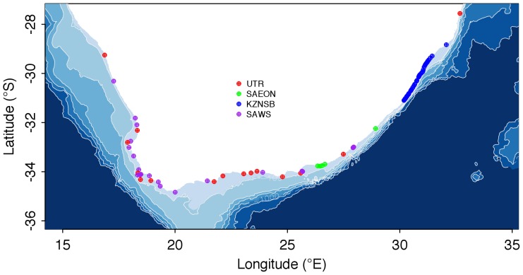
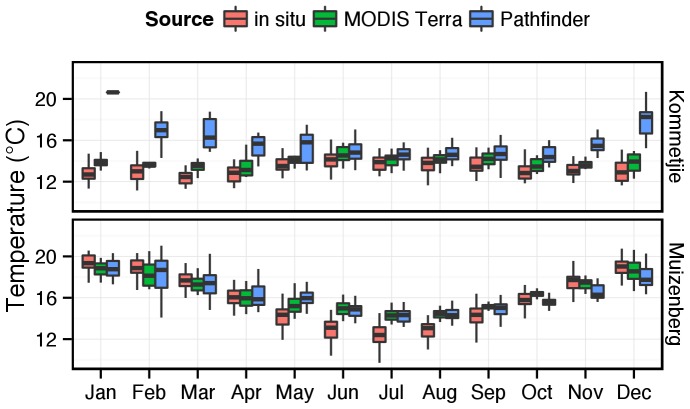
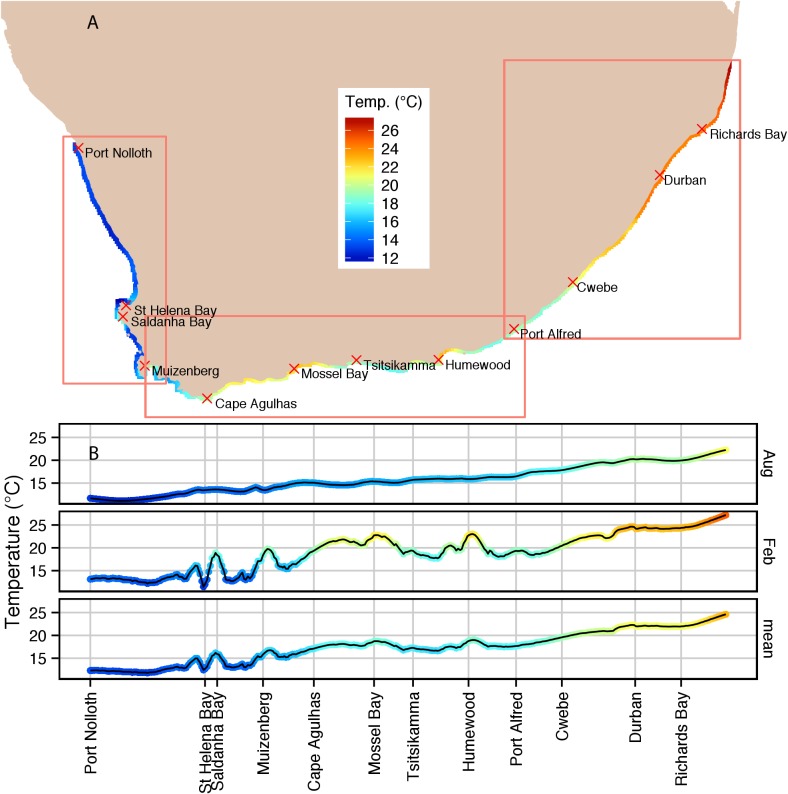
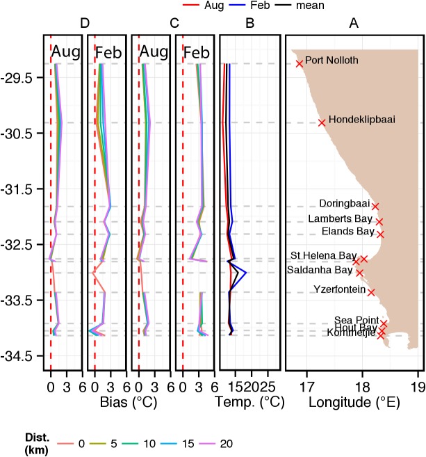
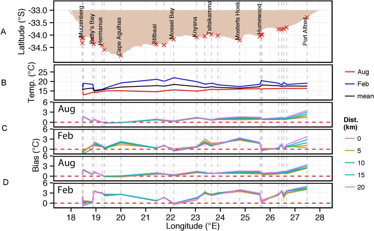
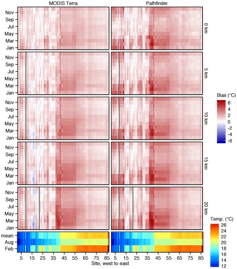
Gridded SST products developed particularly for offshore regions are increasingly being applied close to the coast for biogeographical applications. The purpose of this paper is to demonstrate the dangers of doing so through a comparison of reprocessed MODIS Terra and Pathfinder v5.2 SSTs, both at 4 km resolution, with instrumental in situ temperatures taken within 400 m from the coast. We report large biases of up to +6°C in places between satellite-derived and in situ climatological temperatures for 87 sites spanning the entire ca. 2 700 km of the South African coastline. Although biases are predominantly warm (i.e. the satellite SSTs being higher), smaller or even cold biases also appear in places, especially along the southern and western coasts of the country. We also demonstrate the presence of gradients in temperature biases along shore-normal transects - generally SSTs extracted close to the shore demonstrate a smaller bias with respect to the in situ temperatures. Contributing towards the magnitude of the biases are factors such as SST data source, proximity to the shore, the presence/absence of upwelling cells or coastal embayments. Despite the generally large biases, from a biogeographical perspective, species distribution retains a correlative relationship with underlying spatial patterns in SST, but in order to arrive at a causal understanding of the determinants of biogeographical patterns we suggest that in shallow, inshore marine habitats, temperature is best measured directly.
专门为近海区域开发的网格化 SST 产品越来越多地被应用于靠近海岸的地方,用于生物地理应用。本文的目的是通过比较重处理的 MODIS Terra 和 Pathfinder v5.2 SST,两者的分辨率均为 4 公里,并与从海岸 400 米范围内获取的仪器原位温度进行比较,来展示这样做的危险。我们报告说,在南非整个约 2700 公里的海岸线的 87 个站点,卫星衍生的气候温度与原位气候温度之间存在高达+6°C的大偏差。尽管偏差主要是暖偏差(即卫星 SST 更高),但在某些地方也存在较小甚至冷偏差,尤其是在该国的南部和西部海岸。我们还证明了温度偏差沿着岸线正常横截线上存在梯度 - 通常靠近海岸提取的 SST 相对于原位温度表现出较小的偏差。导致偏差幅度的因素包括 SST 数据源、靠近海岸的距离、上升流细胞或沿海湾口的存在/不存在等。尽管存在普遍较大的偏差,但从生物地理角度来看,物种分布与 SST 中潜在的空间模式保持着相关关系,但为了对生物地理模式的决定因素有因果理解,我们建议在浅海、近岸海洋生境中,最好直接测量温度。