Biogeography Branch, National Centers for Coastal Ocean Science, National Oceanic and Atmospheric Administration, Silver Spring, Maryland, United States of America ; Consolidated Safety Services, Fairfax, Virginia, United States of America.
Center for Coastal Fisheries and Habitat Research, National Centers for Coastal Ocean Science, National Oceanic and Atmospheric Administration, Beaufort, North Carolina, United States of America.
PLoS One. 2014 Jan 15;9(1):e85555. doi: 10.1371/journal.pone.0085555. eCollection 2014.
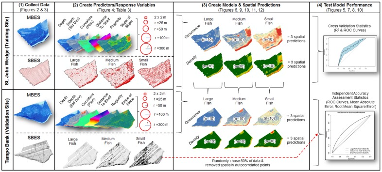
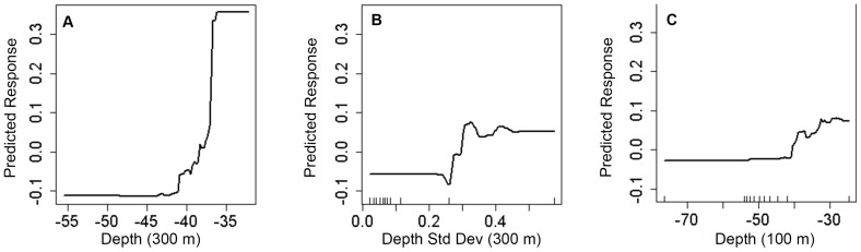
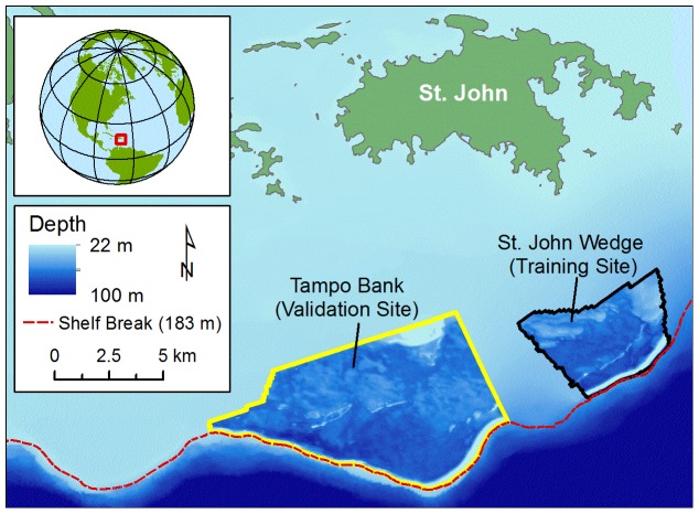
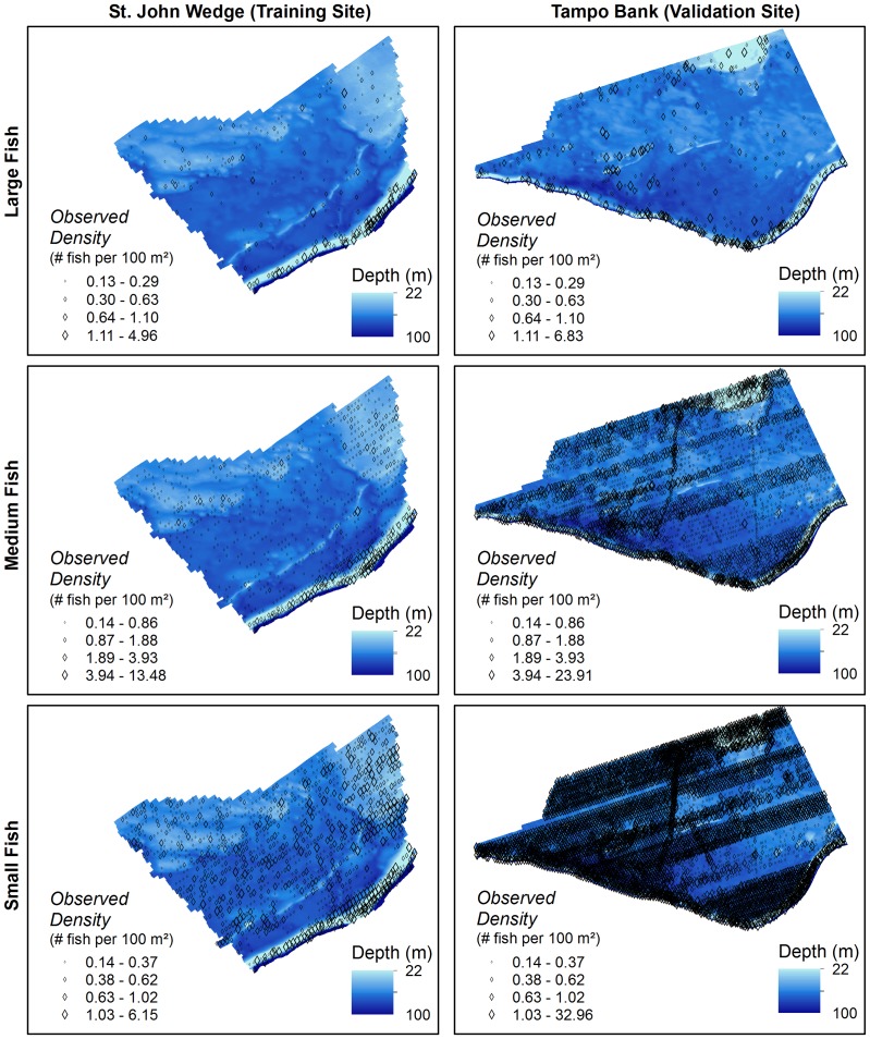
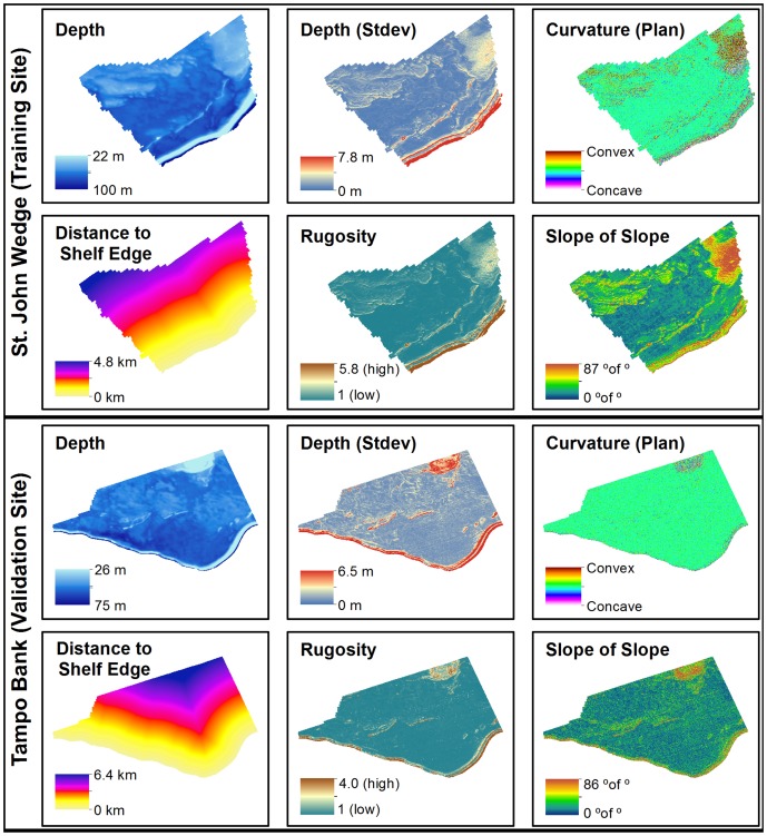
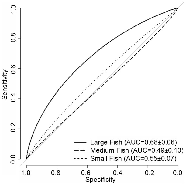
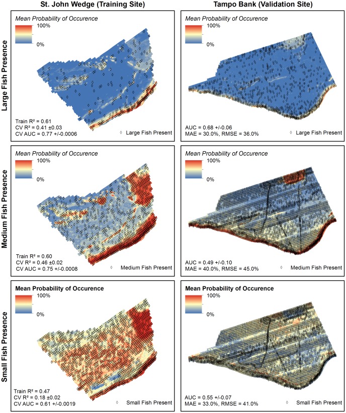
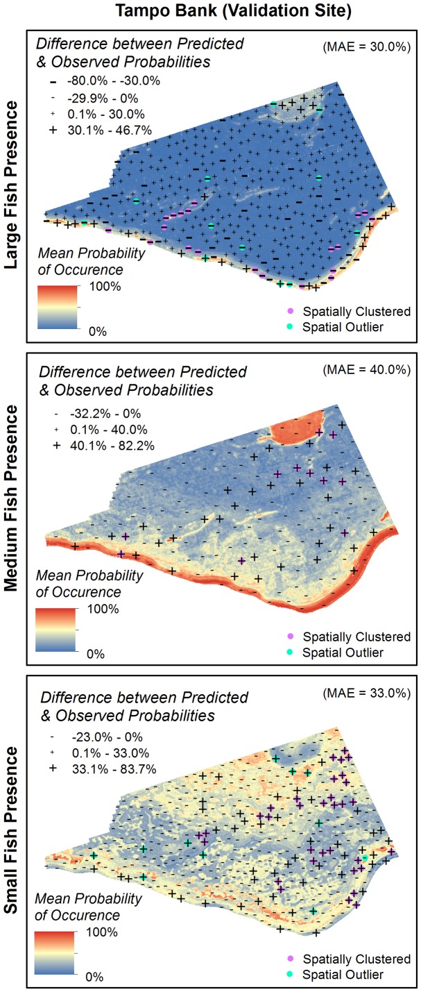
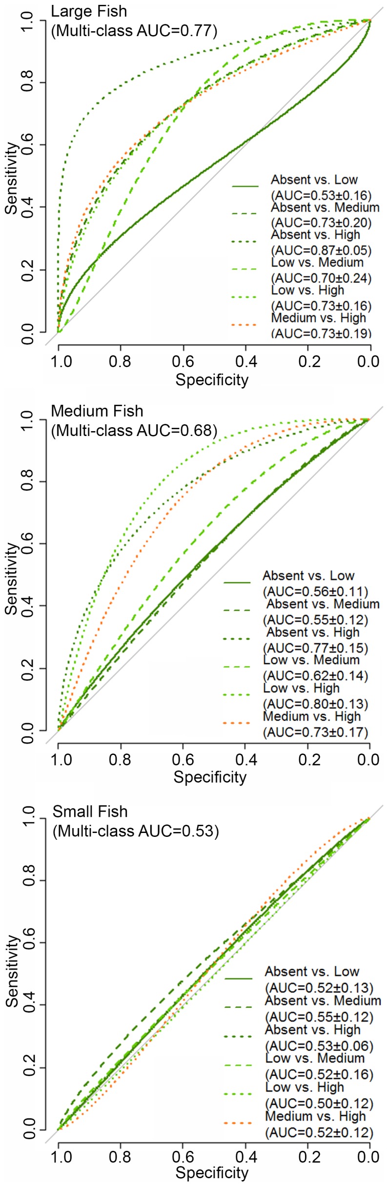
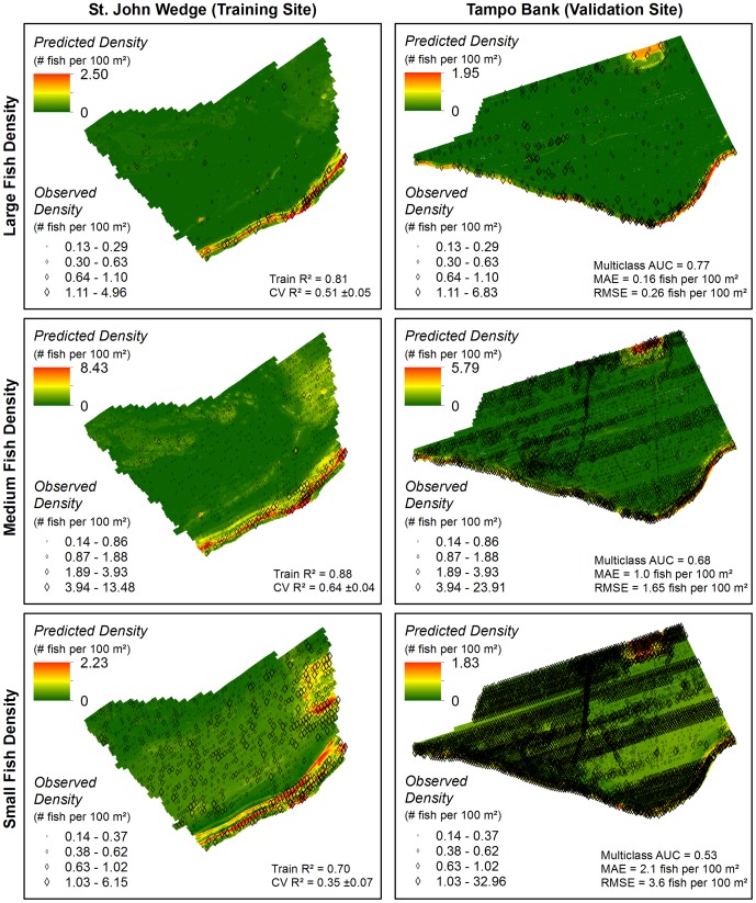
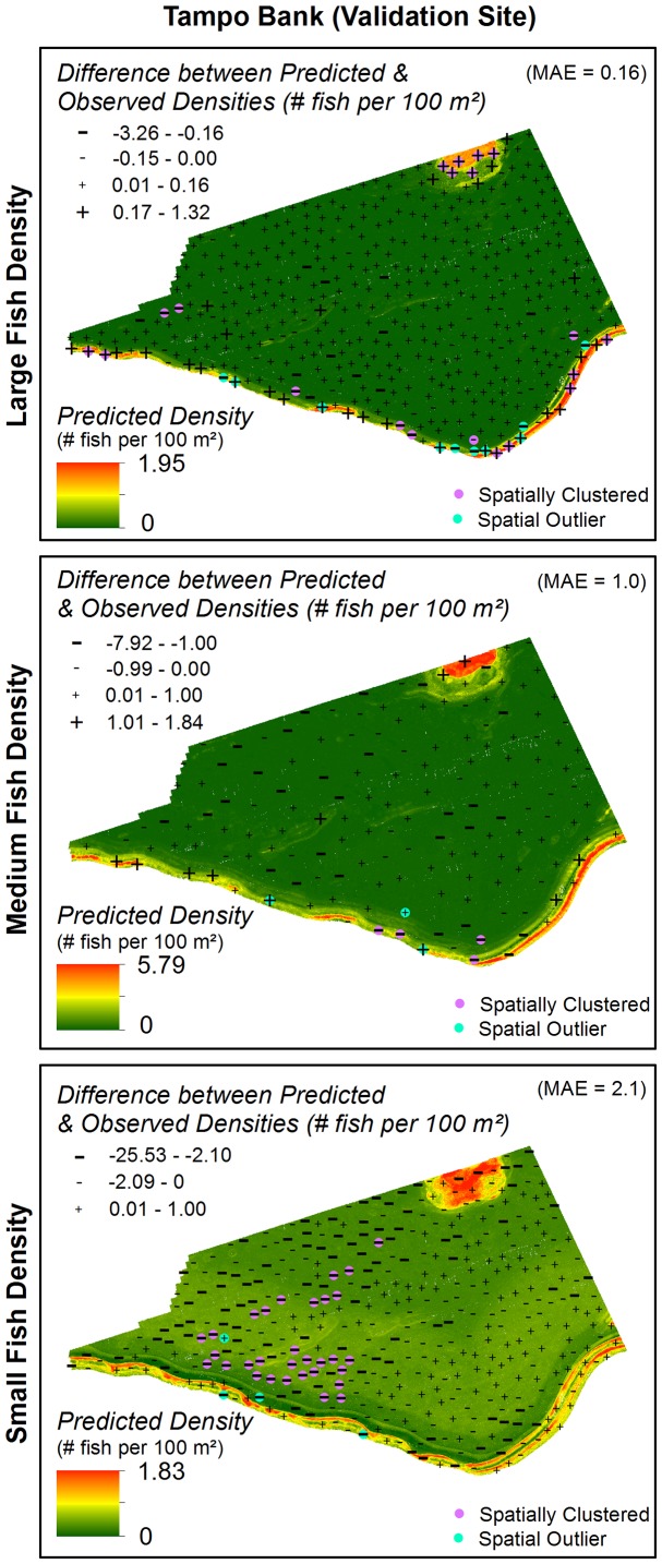
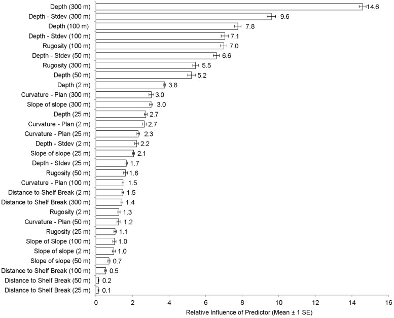
Reef fish distributions are patchy in time and space with some coral reef habitats supporting higher densities (i.e., aggregations) of fish than others. Identifying and quantifying fish aggregations (particularly during spawning events) are often top priorities for coastal managers. However, the rapid mapping of these aggregations using conventional survey methods (e.g., non-technical SCUBA diving and remotely operated cameras) are limited by depth, visibility and time. Acoustic sensors (i.e., splitbeam and multibeam echosounders) are not constrained by these same limitations, and were used to concurrently map and quantify the location, density and size of reef fish along with seafloor structure in two, separate locations in the U.S. Virgin Islands. Reef fish aggregations were documented along the shelf edge, an ecologically important ecotone in the region. Fish were grouped into three classes according to body size, and relationships with the benthic seascape were modeled in one area using Boosted Regression Trees. These models were validated in a second area to test their predictive performance in locations where fish have not been mapped. Models predicting the density of large fish (≥ 29 cm) performed well (i.e., AUC = 0.77). Water depth and standard deviation of depth were the most influential predictors at two spatial scales (100 and 300 m). Models of small (≤ 11 cm) and medium (12-28 cm) fish performed poorly (i.e., AUC = 0.49 to 0.68) due to the high prevalence (45-79%) of smaller fish in both locations, and the unequal prevalence of smaller fish in the training and validation areas. Integrating acoustic sensors with spatial modeling offers a new and reliable approach to rapidly identify fish aggregations and to predict the density large fish in un-surveyed locations. This integrative approach will help coastal managers to prioritize sites, and focus their limited resources on areas that may be of higher conservation value.
珊瑚礁鱼类的分布在时间和空间上是零散的,一些珊瑚礁生境中的鱼类密度(即聚集)比其他生境更高。确定和量化鱼类聚集(特别是在产卵事件期间)通常是沿海管理者的首要任务。然而,使用传统的调查方法(例如非技术性的水肺潜水和遥控摄像机)快速绘制这些聚集图受到深度、能见度和时间的限制。声学传感器(即分束和多波束回声测深仪)不受这些限制的限制,并且用于同时绘制和量化美国维尔京群岛的两个不同位置的珊瑚礁鱼类的位置、密度和大小以及海底结构。在该地区生态重要的生态过渡带沿大陆架边缘记录了鱼类聚集。根据体型将鱼类分为三类,并在一个区域使用 Boosted Regression Trees 对与海底景观的关系进行建模。在第二个区域验证这些模型,以测试它们在未绘制鱼类的位置的预测性能。预测大型鱼类(≥29 厘米)密度的模型表现良好(即 AUC = 0.77)。水深和水深标准差是两个空间尺度(100 和 300 米)上最具影响力的预测因子。小型(≤11 厘米)和中型(12-28 厘米)鱼类的模型表现不佳(即 AUC = 0.49 至 0.68),这是由于两个地点的小鱼比例都很高(45-79%),以及在训练和验证区域中小鱼的比例不均等。将声学传感器与空间模型相结合,为快速识别鱼类聚集和预测未调查地点大型鱼类的密度提供了一种新的可靠方法。这种综合方法将帮助沿海管理者确定优先事项,并将其有限的资源集中在可能具有更高保护价值的区域。