Faculty of Infectious and Tropical Diseases, London School of Hygiene & Tropical Medicine, London, United Kingdom.
Department of Environmental Health, Rollins School of Public Health, Emory University, Atlanta, Georgia, United States of America.
PLoS Med. 2014 Apr 8;11(4):e1001626. doi: 10.1371/journal.pmed.1001626. eCollection 2014 Apr.
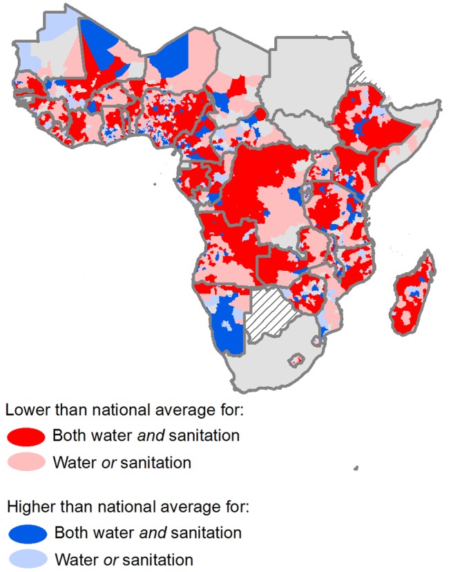
Understanding geographic inequalities in coverage of drinking-water supply and sanitation (WSS) will help track progress towards universal coverage of water and sanitation by identifying marginalized populations, thus helping to control a large number of infectious diseases. This paper uses household survey data to develop comprehensive maps of WSS coverage at high spatial resolution for sub-Saharan Africa (SSA). Analysis is extended to investigate geographic heterogeneity and relative geographic inequality within countries.
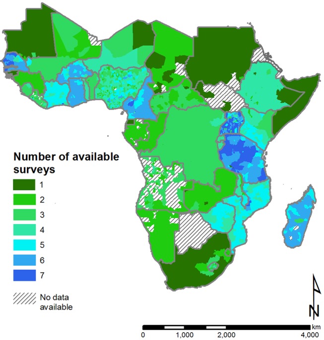
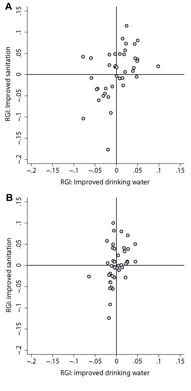
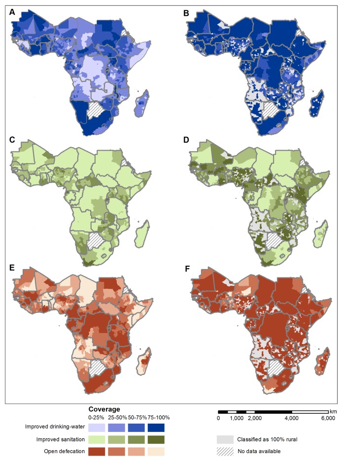
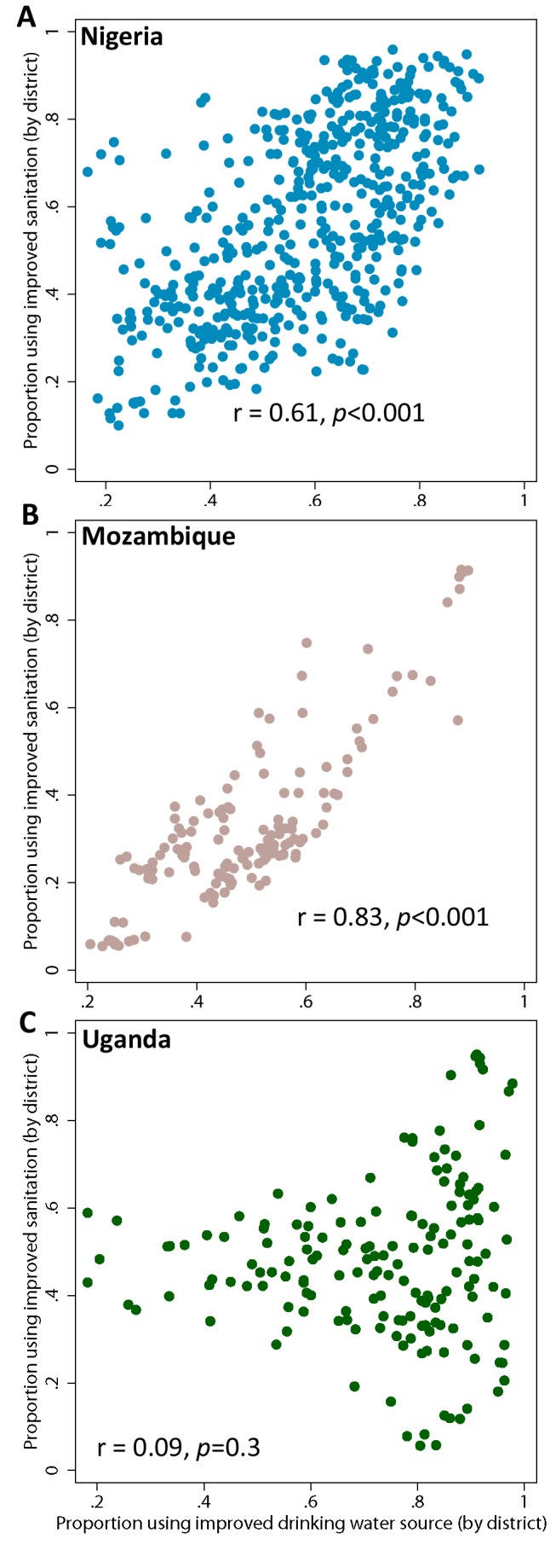
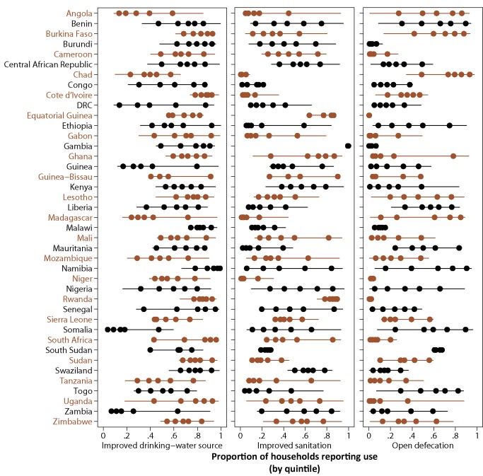
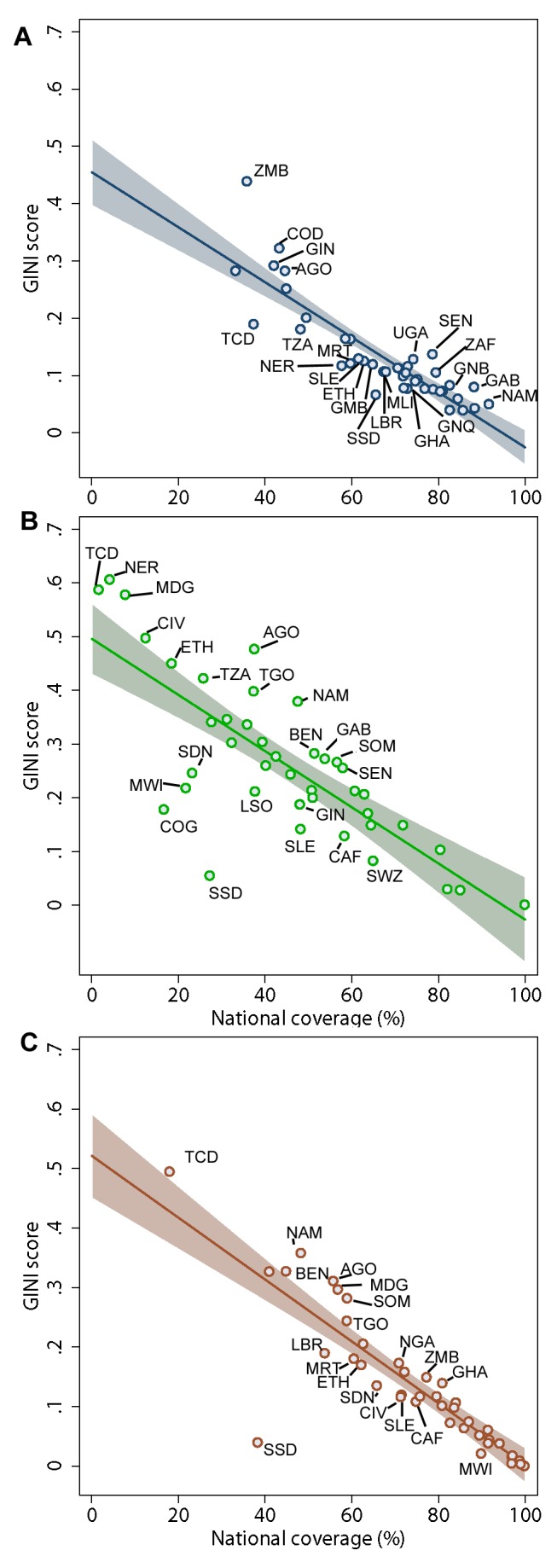
Cluster-level data on household reported use of improved drinking-water supply, sanitation, and open defecation were abstracted from 138 national surveys undertaken from 1991-2012 in 41 countries. Spatially explicit logistic regression models were developed and fitted within a Bayesian framework, and used to predict coverage at the second administrative level (admin2, e.g., district) across SSA for 2012. Results reveal substantial geographical inequalities in predicted use of water and sanitation that exceed urban-rural disparities. The average range in coverage seen between admin2 within countries was 55% for improved drinking water, 54% for use of improved sanitation, and 59% for dependence upon open defecation. There was also some evidence that countries with higher levels of inequality relative to coverage in use of an improved drinking-water source also experienced higher levels of inequality in use of improved sanitation (rural populations r = 0.47, p = 0.002; urban populations r = 0.39, p = 0.01). Results are limited by the quantity of WSS data available, which varies considerably by country, and by the reliability and utility of available indicators.
This study identifies important geographic inequalities in use of WSS previously hidden within national statistics, confirming the necessity for targeted policies and metrics that reach the most marginalized populations. The presented maps and analysis approach can provide a mechanism for monitoring future reductions in inequality within countries, reflecting priorities of the post-2015 development agenda. Please see later in the article for the Editors' Summary.
了解饮用水供应和卫生设施(WSS)覆盖方面的地域不平等情况,有助于通过确定被边缘化的人群来跟踪水和卫生设施普及方面的进展,从而有助于控制大量传染病。本文利用家庭调查数据,以高空间分辨率为撒哈拉以南非洲(SSA)制定了 WSS 覆盖情况的综合地图。分析还扩展到调查国家内部的地域异质性和相对地域不平等。
从 1991 年至 2012 年在 41 个国家进行的 138 次国家调查中,提取了有关家庭报告使用改良饮用水供应、卫生和露天排便的群集级数据。在贝叶斯框架内开发并拟合了空间明确的逻辑回归模型,并将其用于预测 2012 年 SSA 内第二级行政区域(例如区)的覆盖情况。结果表明,在预测水和卫生设施的使用方面存在着相当大的地域不平等,这种不平等程度超过了城乡差异。在国家内部,预测的改良饮用水覆盖范围的平均差异为 55%,改良卫生设施的使用覆盖率为 54%,对露天排便的依赖率为 59%。还有一些证据表明,与改良饮用水来源使用覆盖水平相比,不平等程度较高的国家在改良卫生设施使用方面也存在更高程度的不平等(农村人口 r=0.47,p=0.002;城市人口 r=0.39,p=0.01)。结果受到 WSS 数据可用性的限制,这些数据在国家之间有很大差异,并且受到现有指标的可靠性和实用性的限制。
本研究确定了在使用 WSS 方面以前隐藏在国家统计数据中的重要地域不平等现象,证实了有必要制定针对最边缘化人群的有针对性政策和指标。本文提出的地图和分析方法可以为监测未来国家内部不平等现象的减少提供一种机制,这反映了 2015 年后发展议程的优先事项。请参阅文章后面的编辑摘要。