• 文献检索
  • 文档翻译
  • 深度研究
  • 学术资讯
  • Suppr Zotero 插件Zotero 插件
  • 邀请有礼
  • 套餐&价格
  • 历史记录
应用&插件
Suppr Zotero 插件Zotero 插件浏览器插件Mac 客户端Windows 客户端微信小程序
定价
高级版会员购买积分包购买API积分包
服务
文献检索文档翻译深度研究API 文档MCP 服务
关于我们
关于 Suppr公司介绍联系我们用户协议隐私条款
关注我们

Suppr 超能文献

核心技术专利:CN118964589B侵权必究
粤ICP备2023148730 号-1Suppr @ 2026

文献检索

告别复杂PubMed语法,用中文像聊天一样搜索,搜遍4000万医学文献。AI智能推荐,让科研检索更轻松。

立即免费搜索

文件翻译

保留排版,准确专业,支持PDF/Word/PPT等文件格式,支持 12+语言互译。

免费翻译文档

深度研究

AI帮你快速写综述,25分钟生成高质量综述,智能提取关键信息,辅助科研写作。

立即免费体验

加拿大魁北克省臭氧水平的时空建模:克里金法、土地利用回归(LUR)以及贝叶斯最大熵-LUR组合方法的比较

Spatiotemporal modeling of ozone levels in Quebec (Canada): a comparison of kriging, land-use regression (LUR), and combined Bayesian maximum entropy-LUR approaches.

作者信息

Adam-Poupart Ariane, Brand Allan, Fournier Michel, Jerrett Michael, Smargiassi Audrey

机构信息

Department of Environmental and Occupational Health, Faculty of Public Health, Université de Montréal, Montréal, Québec, Canada.

出版信息

Environ Health Perspect. 2014 Sep;122(9):970-6. doi: 10.1289/ehp.1306566. Epub 2014 May 30.

DOI:10.1289/ehp.1306566
PMID:24879650
原文链接:https://pmc.ncbi.nlm.nih.gov/articles/PMC4153742/
Abstract

BACKGROUND

Ambient air ozone (O3) is a pulmonary irritant that has been associated with respiratory health effects including increased lung inflammation and permeability, airway hyperreactivity, respiratory symptoms, and decreased lung function. Estimation of O3 exposure is a complex task because the pollutant exhibits complex spatiotemporal patterns. To refine the quality of exposure estimation, various spatiotemporal methods have been developed worldwide.

OBJECTIVES

We sought to compare the accuracy of three spatiotemporal models to predict summer ground-level O3 in Quebec, Canada.

METHODS

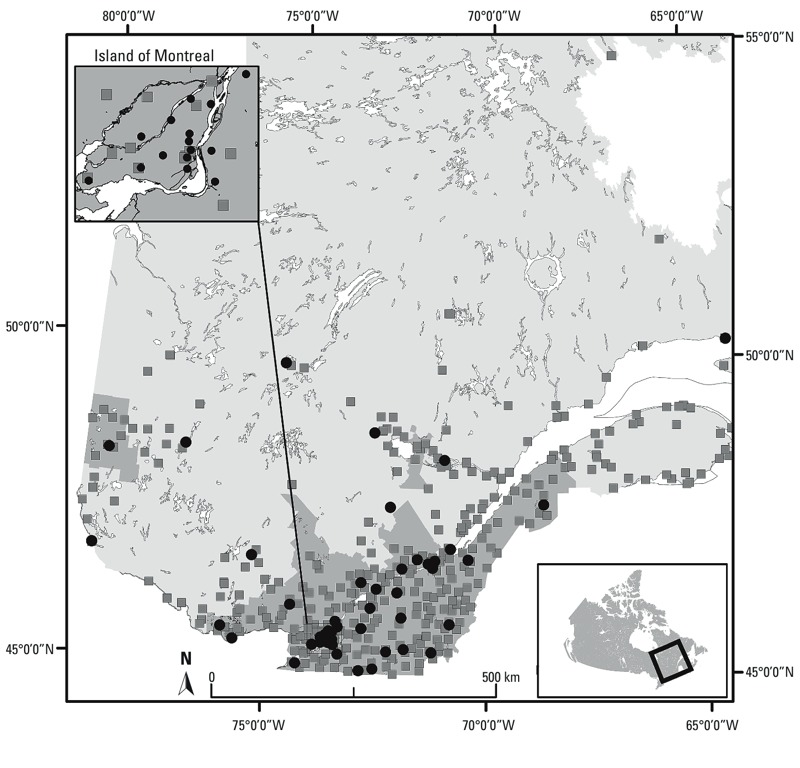
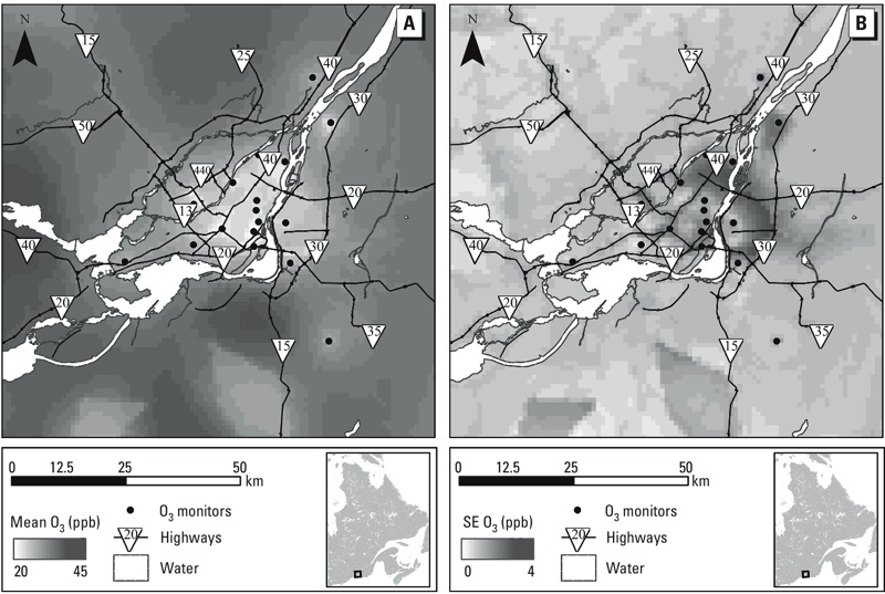
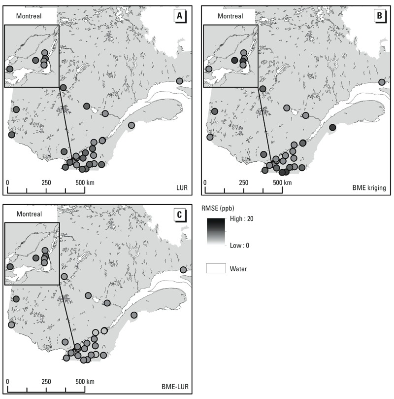
We developed a land-use mixed-effects regression (LUR) model based on readily available data (air quality and meteorological monitoring data, road networks information, latitude), a Bayesian maximum entropy (BME) model incorporating both O3 monitoring station data and the land-use mixed model outputs (BME-LUR), and a kriging method model based only on available O3 monitoring station data (BME kriging). We performed leave-one-station-out cross-validation and visually assessed the predictive capability of each model by examining the mean temporal and spatial distributions of the average estimated errors.

RESULTS

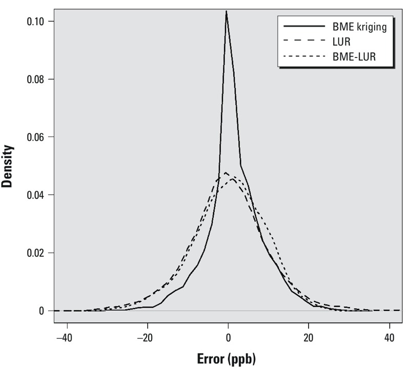
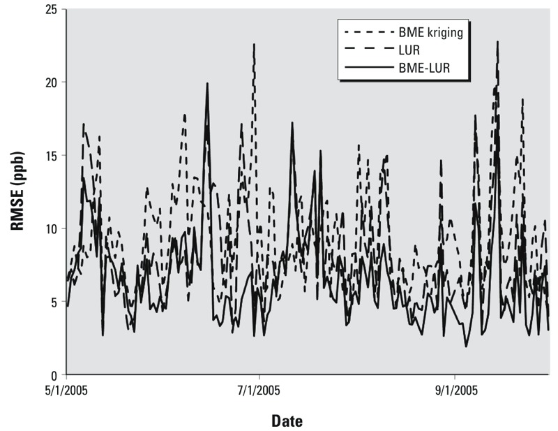
The BME-LUR was the best predictive model (R2 = 0.653) with the lowest root mean-square error (RMSE ;7.06 ppb), followed by the LUR model (R2 = 0.466, RMSE = 8.747) and the BME kriging model (R2 = 0.414, RMSE = 9.164).

CONCLUSIONS

Our findings suggest that errors of estimation in the interpolation of O3 concentrations with BME can be greatly reduced by incorporating outputs from a LUR model developed with readily available data.

摘要

背景

环境空气中的臭氧(O₃)是一种肺部刺激物,与多种呼吸系统健康影响相关,包括肺部炎症和通透性增加、气道高反应性、呼吸道症状以及肺功能下降。由于该污染物呈现复杂的时空模式,因此估算臭氧暴露是一项复杂的任务。为了提高暴露估算的质量,全球已开发出各种时空方法。

目的

我们试图比较三种时空模型预测加拿大魁北克夏季地面臭氧水平的准确性。

方法

我们基于现成数据(空气质量和气象监测数据、道路网络信息、纬度)开发了一个土地利用混合效应回归(LUR)模型,一个结合臭氧监测站数据和土地利用混合模型输出的贝叶斯最大熵(BME)模型(BME-LUR),以及一个仅基于现有臭氧监测站数据的克里金方法模型(BME克里金)。我们进行了留一法交叉验证,并通过检查平均估计误差的平均时间和空间分布直观地评估了每个模型的预测能力。

结果

BME-LUR是最佳预测模型(R² = 0.653),均方根误差最低(RMSE;7.06 ppb),其次是LUR模型(R² = 0.466,RMSE = 8.747)和BME克里金模型(R² = 0.414,RMSE = 9.164)。

结论

我们的研究结果表明,通过纳入利用现成数据开发的LUR模型的输出,可以大大减少使用BME插值臭氧浓度时的估计误差。

https://cdn.ncbi.nlm.nih.gov/pmc/blobs/5621/4153742/392c8b9c98fb/ehp.1306566.g005.jpg
https://cdn.ncbi.nlm.nih.gov/pmc/blobs/5621/4153742/3079e49015da/ehp.1306566.g001.jpg
https://cdn.ncbi.nlm.nih.gov/pmc/blobs/5621/4153742/4b1e50952dab/ehp.1306566.g002.jpg
https://cdn.ncbi.nlm.nih.gov/pmc/blobs/5621/4153742/b96c3f42fb20/ehp.1306566.g003.jpg
https://cdn.ncbi.nlm.nih.gov/pmc/blobs/5621/4153742/81474829e9cc/ehp.1306566.g004.jpg
https://cdn.ncbi.nlm.nih.gov/pmc/blobs/5621/4153742/392c8b9c98fb/ehp.1306566.g005.jpg

相似文献

1
Spatiotemporal modeling of ozone levels in Quebec (Canada): a comparison of kriging, land-use regression (LUR), and combined Bayesian maximum entropy-LUR approaches.加拿大魁北克省臭氧水平的时空建模:克里金法、土地利用回归(LUR)以及贝叶斯最大熵-LUR组合方法的比较
Environ Health Perspect. 2014 Sep;122(9):970-6. doi: 10.1289/ehp.1306566. Epub 2014 May 30.
2
Spatiotemporal modeling of PM concentrations at the national scale combining land use regression and Bayesian maximum entropy in China.在中国,结合土地利用回归和贝叶斯最大熵模型进行国家尺度 PM 浓度的时空建模。
Environ Int. 2018 Jul;116:300-307. doi: 10.1016/j.envint.2018.03.047. Epub 2018 May 3.
3
Comparison of model estimates from an intra-city land use regression model with a national satellite-LUR and a regional Bayesian Maximum Entropy model, in estimating NO for a birth cohort in Sydney, Australia.比较城市内土地利用回归模型、全国卫星-土地利用回归模型和区域贝叶斯最大熵模型的模型估计值,以估算澳大利亚悉尼出生队列的 NO 浓度。
Environ Res. 2019 Jul;174:24-34. doi: 10.1016/j.envres.2019.03.068. Epub 2019 Mar 29.
4
Spatial modeling of daily concentrations of ground-level ozone in Montreal, Canada: A comparison of geostatistical approaches.加拿大蒙特利尔地区地面臭氧日浓度的空间建模:地统计学方法比较。
Environ Res. 2018 Oct;166:487-496. doi: 10.1016/j.envres.2018.06.036. Epub 2018 Jun 26.
5
Combining Land-Use Regression and Chemical Transport Modeling in a Spatiotemporal Geostatistical Model for Ozone and PM2.5.在用于臭氧和PM2.5的时空地质统计模型中结合土地利用回归与化学传输模型
Environ Sci Technol. 2016 May 17;50(10):5111-8. doi: 10.1021/acs.est.5b06001. Epub 2016 Apr 26.
6
Comparison of spatiotemporal prediction models of daily exposure of individuals to ambient nitrogen dioxide and ozone in Montreal, Canada.加拿大蒙特利尔市个体每日环境二氧化氮和臭氧暴露的时空预测模型比较
Environ Res. 2017 Jul;156:201-230. doi: 10.1016/j.envres.2017.03.017. Epub 2017 Mar 28.
7
A hybrid approach to estimating long-term and short-term exposure levels of ozone at the national scale in China using land use regression and Bayesian maximum entropy.利用土地利用回归和贝叶斯最大熵方法在中国国家尺度上对臭氧的长期和短期暴露水平进行混合估计的方法。
Sci Total Environ. 2021 Jan 15;752:141780. doi: 10.1016/j.scitotenv.2020.141780. Epub 2020 Aug 22.
8
Evaluating heterogeneity in indoor and outdoor air pollution using land-use regression and constrained factor analysis.利用土地利用回归和约束因子分析评估室内和室外空气污染的异质性。
Res Rep Health Eff Inst. 2010 Dec(152):5-80; discussion 81-91.
9
BME estimation of residential exposure to ambient PM10 and ozone at multiple time scales.多时间尺度下环境空气中PM10和臭氧的居民暴露的生物标志物暴露估计
Environ Health Perspect. 2009 Apr;117(4):537-44. doi: 10.1289/ehp.0800089. Epub 2008 Dec 15.
10
Comparison of Machine Learning and Land Use Regression for fine scale spatiotemporal estimation of ambient air pollution: Modeling ozone concentrations across the contiguous United States.机器学习和土地利用回归在精细时空估算环境空气污染中的比较:在美国大陆范围内模拟臭氧浓度。
Environ Int. 2020 Sep;142:105827. doi: 10.1016/j.envint.2020.105827. Epub 2020 Jun 25.

引用本文的文献

1
Parsimonious estimation of hourly surface ozone concentration across China during 2015-2020.2015-2020 年中国小时臭氧浓度的简约估计。
Sci Data. 2024 May 14;11(1):492. doi: 10.1038/s41597-024-03302-3.
2
Identification of Neighborhood Hotspots via the Cumulative Hazard Index: Results From a Community-Partnered Low-Cost Sensor Deployment.通过累积风险指数识别社区热点:社区合作低成本传感器部署的结果
Geohealth. 2024 Feb 14;8(2):e2023GH000935. doi: 10.1029/2023GH000935. eCollection 2024 Feb.
3
Variation trend prediction of ground-level ozone concentrations with high-resolution using landscape pattern data.

本文引用的文献

1
Characterization of Ambient Air Pollution Measurement Error in a Time-Series Health Study using a Geostatistical Simulation Approach.在一项时间序列健康研究中使用地质统计模拟方法对环境空气污染测量误差进行特征分析
Atmos Environ (1994). 2012 Sep;57:101-108. doi: 10.1016/j.atmosenv.2012.04.045.
2
Bayesian maximum entropy integration of ozone observations and model predictions: an application for attainment demonstration in North Carolina.贝叶斯最大熵法整合臭氧观测值与模型预测值:在北卡罗来纳州达标论证中的应用。
Environ Sci Technol. 2010 Aug 1;44(15):5707-13. doi: 10.1021/es100228w.
3
BME estimation of residential exposure to ambient PM10 and ozone at multiple time scales.
利用景观格局数据进行高分辨率下的近地面臭氧浓度变化趋势预测。
PLoS One. 2023 Nov 16;18(11):e0294038. doi: 10.1371/journal.pone.0294038. eCollection 2023.
4
Spatio-Temporal Variation-Induced Group Disparity of Intra-Urban NO Exposure.城市内 NO 暴露的时空变化引起的群体差异。
Int J Environ Res Public Health. 2022 May 12;19(10):5872. doi: 10.3390/ijerph19105872.
5
Satellite-Based Long-Term Spatiotemporal Patterns of Surface Ozone Concentrations in China: 2005-2019.基于卫星的中国地区 2005-2019 年表面臭氧浓度的长期时空分布特征。
Environ Health Perspect. 2022 Feb;130(2):27004. doi: 10.1289/EHP9406. Epub 2022 Feb 9.
6
A comparison of statistical and machine learning methods for creating national daily maps of ambient PM concentration.用于创建全国每日环境颗粒物浓度地图的统计方法与机器学习方法比较
Atmos Environ (1994). 2020 Feb 1;222. doi: 10.1016/j.atmosenv.2019.117130. Epub 2019 Nov 14.
7
Enhancing Models and Measurements of Traffic-Related Air Pollutants for Health Studies Using Dispersion Modeling and Bayesian Data Fusion.利用扩散模型和贝叶斯数据融合技术改进交通相关空气污染物的模型和测量方法,以用于健康研究。
Res Rep Health Eff Inst. 2020 Mar;2020(202):1-63.
8
Assessment of the spatio-temporal pattern of PM and its driving factors using a land use regression model in Beijing, China.利用土地利用回归模型评估中国北京地区 PM 的时空分布模式及其驱动因素。
Environ Monit Assess. 2020 Jan 6;192(2):95. doi: 10.1007/s10661-019-7943-9.
9
Voxel Forecast for Precision Oncology: Predicting Spatially Variant and Multiscale Cancer Therapy Response on Longitudinal Quantitative Molecular Imaging.体素预测精准肿瘤学:在纵向定量分子成像上预测空间变化和多尺度癌症治疗反应。
Clin Cancer Res. 2019 Aug 15;25(16):5027-5037. doi: 10.1158/1078-0432.CCR-18-3908. Epub 2019 May 29.
10
Spatial estimation of surface ozone concentrations in Quito Ecuador with remote sensing data, air pollution measurements and meteorological variables.厄瓜多尔基多市的遥感数据、空气污染测量和气象变量与地表臭氧浓度的空间估算。
Environ Monit Assess. 2019 Feb 11;191(3):155. doi: 10.1007/s10661-019-7286-6.
多时间尺度下环境空气中PM10和臭氧的居民暴露的生物标志物暴露估计
Environ Health Perspect. 2009 Apr;117(4):537-44. doi: 10.1289/ehp.0800089. Epub 2008 Dec 15.
4
Air pollution exposure assessment methods utilized in epidemiological studies.流行病学研究中使用的空气污染暴露评估方法。
J Environ Monit. 2009 Mar;11(3):475-90. doi: 10.1039/b813889c. Epub 2009 Feb 13.
5
Long-term ozone exposure and mortality.长期臭氧暴露与死亡率。
N Engl J Med. 2009 Mar 12;360(11):1085-95. doi: 10.1056/NEJMoa0803894.
6
Mapping of background air pollution at a fine spatial scale across the European Union.在欧盟范围内以精细空间尺度绘制背景空气污染图。
Sci Total Environ. 2009 Mar 1;407(6):1852-67. doi: 10.1016/j.scitotenv.2008.11.048. Epub 2009 Jan 18.
7
Outdoor air pollution: ozone health effects.室外空气污染:臭氧对健康的影响。
Am J Med Sci. 2007 Apr;333(4):244-8. doi: 10.1097/MAJ.0b013e31803b8e8c.
8
The use of ambient air quality modeling to estimate individual and population exposure for human health research: a case study of ozone in the Northern Georgia Region of the United States.利用环境空气质量模型估算人类健康研究中的个体和群体暴露:以美国佐治亚州北部地区的臭氧为例
Environ Int. 2006 Jul;32(5):586-93. doi: 10.1016/j.envint.2006.01.005. Epub 2006 Mar 6.
9
The role of GIS: coping with space (and time) in air pollution exposure assessment.地理信息系统的作用:在空气污染暴露评估中应对空间(和时间)问题。
J Toxicol Environ Health A. 2005;68(13-14):1243-61. doi: 10.1080/15287390590936094.
10
A review and evaluation of intraurban air pollution exposure models.城市内部空气污染暴露模型的综述与评估。
J Expo Anal Environ Epidemiol. 2005 Mar;15(2):185-204. doi: 10.1038/sj.jea.7500388.