Haenssgen Marco J
Centre for Tropical Medicine and Global Health, Nuffield Department of Medicine, University of Oxford, Oxford, UK ; CABDyN Complexity Centre, Saïd Business School, University of Oxford, Oxford, UK ; Green Templeton College, University of Oxford, Oxford, UK.
Emerg Themes Epidemiol. 2015 Dec 23;12:20. doi: 10.1186/s12982-015-0041-8. eCollection 2015.
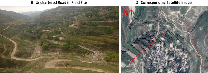
The increasing availability of online maps, satellite imagery, and digital technology can ease common constraints of survey sampling in low- and middle-income countries. However, existing approaches require specialised software and user skills, professional GPS equipment, and/or commercial data sources; they tend to neglect spatial sampling considerations when using satellite maps; and they continue to face implementation challenges analogous to conventional survey implementation methods. This paper presents an alternative way of utilising satellite maps and digital aides that aims to address these challenges.
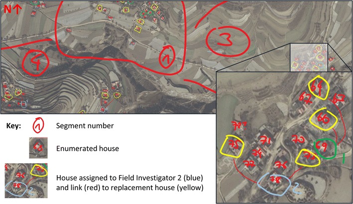
The case studies of two rural household surveys in Rajasthan (India) and Gansu (China) compare conventional survey sampling and implementation techniques with the use of online map services such as Google, Bing, and HERE maps. Modern yet basic digital technology can be integrated into the processes of preparing, implementing, and monitoring a rural household survey. Satellite-aided systematic random sampling enhanced the spatial representativeness of the village samples and entailed savings of approximately £4000 compared to conventional household listing, while reducing the duration of the main survey by at least 25 %.
This low-cost/low-tech satellite-aided survey sampling approach can be useful for student researchers and resource-constrained research projects operating in low- and middle-income contexts with high survey implementation costs. While achieving transparent and efficient survey implementation at low costs, researchers aiming to adopt a similar process should be aware of the locational, technical, and logistical requirements as well as the methodological challenges of this strategy.
在线地图、卫星图像和数字技术的日益普及能够缓解低收入和中等收入国家调查抽样中的常见限制。然而,现有方法需要专业软件和用户技能、专业GPS设备及/或商业数据源;在使用卫星地图时往往忽略空间抽样考量;并且它们仍面临与传统调查实施方法类似的实施挑战。本文提出了一种利用卫星地图和数字辅助工具的替代方法,旨在应对这些挑战。
在印度拉贾斯坦邦和中国甘肃进行的两项农村家庭调查案例研究,将传统调查抽样和实施技术与使用谷歌、必应和HERE地图等在线地图服务的情况进行了比较。现代但基础的数字技术可融入农村家庭调查的准备、实施和监测过程。与传统住户列表相比,卫星辅助系统随机抽样提高了村庄样本的空间代表性,节省了约4000英镑,同时将主要调查的持续时间缩短了至少25%。
这种低成本/低技术的卫星辅助调查抽样方法对于在调查实施成本高昂的低收入和中等收入环境中开展研究的学生研究人员和资源有限的研究项目可能有用。在以低成本实现透明且高效的调查实施的同时,旨在采用类似流程的研究人员应了解该策略的位置、技术和后勤要求以及方法学挑战。