• 文献检索
  • 文档翻译
  • 深度研究
  • 学术资讯
  • Suppr Zotero 插件Zotero 插件
  • 邀请有礼
  • 套餐&价格
  • 历史记录
应用&插件
Suppr Zotero 插件Zotero 插件浏览器插件Mac 客户端Windows 客户端微信小程序
定价
高级版会员购买积分包购买API积分包
服务
文献检索文档翻译深度研究API 文档MCP 服务
关于我们
关于 Suppr公司介绍联系我们用户协议隐私条款
关注我们

Suppr 超能文献

核心技术专利:CN118964589B侵权必究
粤ICP备2023148730 号-1Suppr @ 2026

文献检索

告别复杂PubMed语法,用中文像聊天一样搜索,搜遍4000万医学文献。AI智能推荐,让科研检索更轻松。

立即免费搜索

文件翻译

保留排版,准确专业,支持PDF/Word/PPT等文件格式,支持 12+语言互译。

免费翻译文档

深度研究

AI帮你快速写综述,25分钟生成高质量综述,智能提取关键信息,辅助科研写作。

立即免费体验

基于对象的全波形机载激光扫描数据点云分析用于城市植被分类

Object-Based Point Cloud Analysis of Full-Waveform Airborne Laser Scanning Data for Urban Vegetation Classification.

作者信息

Rutzinger Martin, Höfle Bernhard, Hollaus Markus, Pfeifer Norbert

机构信息

alpS - Centre for Natural Hazard Management, Grabenweg 3, A-6020 Innsbruck, Austria.

Institute of Geography, University of Innsbruck, Innrain 52, A-6020 Innsbruck, Austria.

出版信息

Sensors (Basel). 2008 Aug 4;8(8):4505-4528. doi: 10.3390/s8084505.

DOI:10.3390/s8084505
PMID:27873771
原文链接:https://pmc.ncbi.nlm.nih.gov/articles/PMC3705457/
Abstract

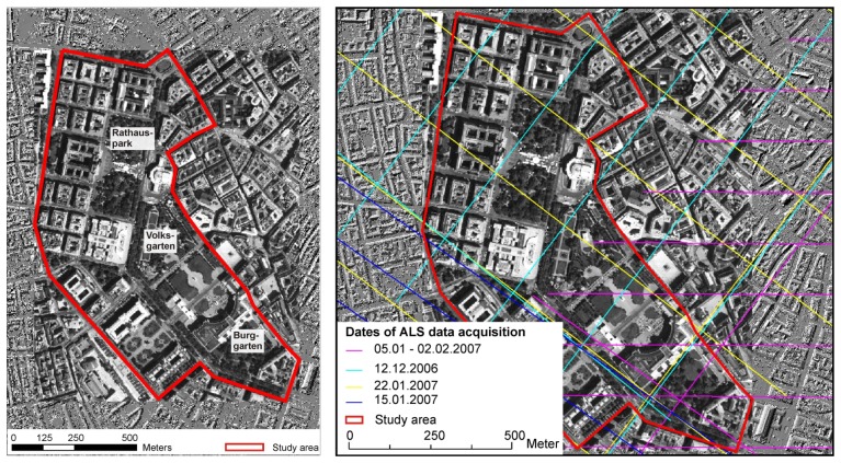
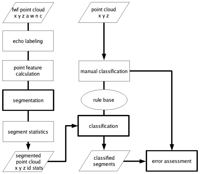
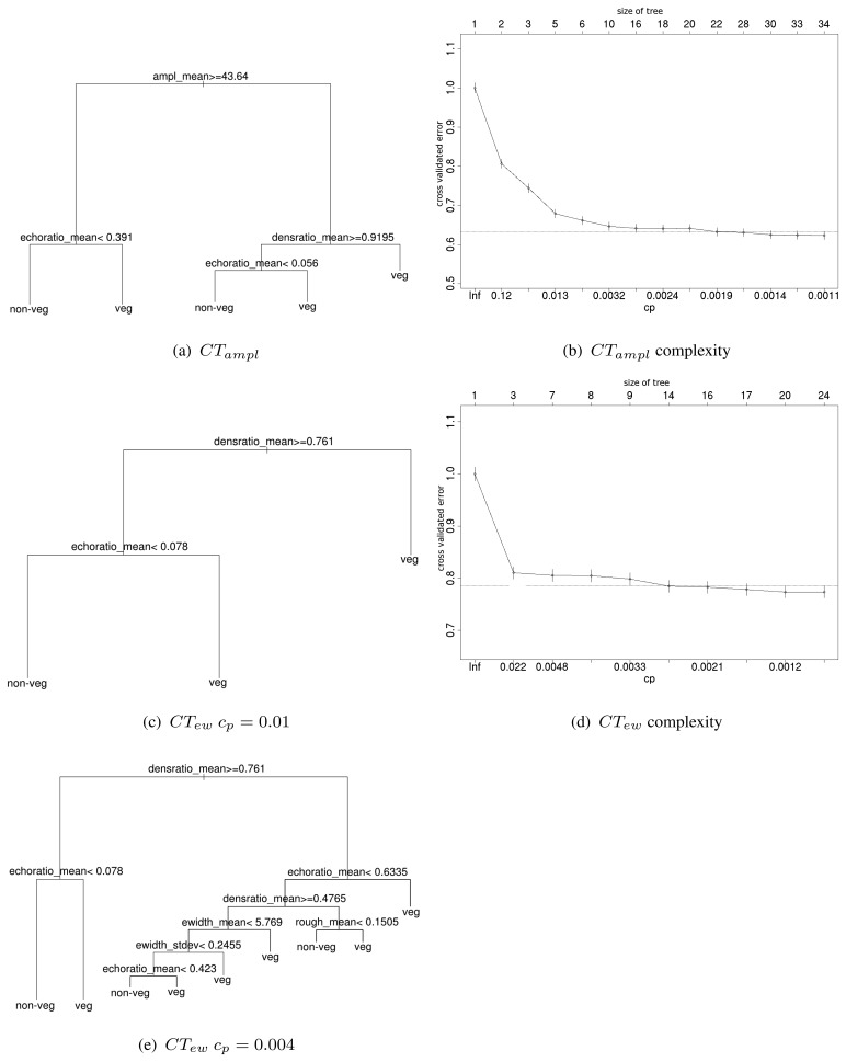
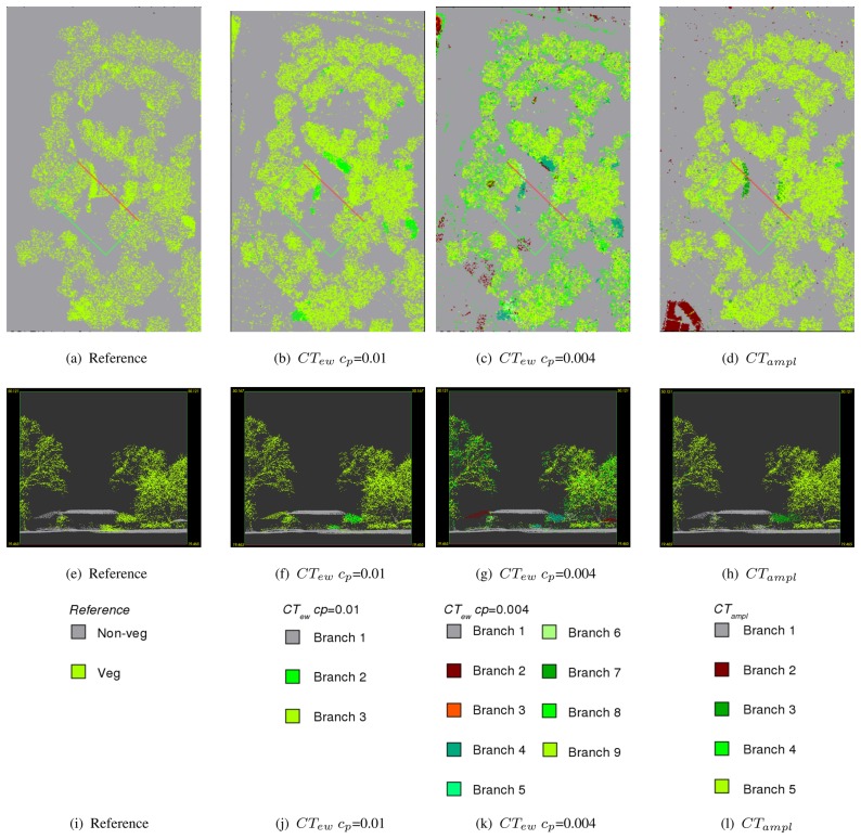
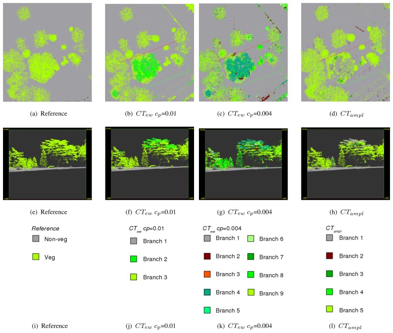
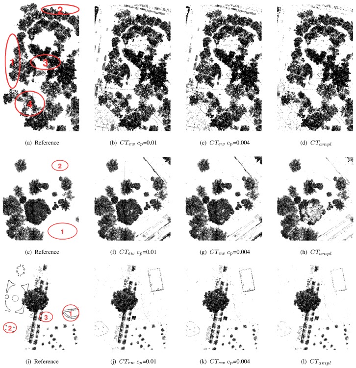
Airborne laser scanning (ALS) is a remote sensing technique well-suited for 3D vegetation mapping and structure characterization because the emitted laser pulses are able to penetrate small gaps in the vegetation canopy. The backscattered echoes from the foliage, woody vegetation, the terrain, and other objects are detected, leading to a cloud of points. Higher echo densities (> 20 echoes/m2) and additional classification variables from full-waveform (FWF) ALS data, namely echo amplitude, echo width and information on multiple echoes from one shot, offer new possibilities in classifying the ALS point cloud. Currently FWF sensor information is hardly used for classification purposes. This contribution presents an object-based point cloud analysis (OBPA) approach, combining segmentation and classification of the 3D FWF ALS points designed to detect tall vegetation in urban environments. The definition tall vegetation includes trees and shrubs, but excludes grassland and herbage. In the applied procedure FWF ALS echoes are segmented by a seeded region growing procedure. All echoes sorted descending by their surface roughness are used as seed points. Segments are grown based on echo width homogeneity. Next, segment statistics (mean, standard deviation, and coefficient of variation) are calculated by aggregating echo features such as amplitude and surface roughness. For classification a rule base is derived automatically from a training area using a statistical classification tree. To demonstrate our method we present data of three sites with around 500,000 echoes each. The accuracy of the classified vegetation segments is evaluated for two independent validation sites. In a point-wise error assessment, where the classification is compared with manually classified 3D points, completeness and correctness better than 90% are reached for the validation sites. In comparison to many other algorithms the proposed 3D point classification works on the original measurements directly, i.e. the acquired points. Gridding of the data is not necessary, a process which is inherently coupled to loss of data and precision. The 3D properties provide especially a good separability of buildings and terrain points respectively, if they are occluded by vegetation.

摘要

机载激光扫描(ALS)是一种非常适合三维植被测绘和结构特征描述的遥感技术,因为发射的激光脉冲能够穿透植被冠层中的小间隙。可以检测到来自树叶、木本植被、地形及其他物体的后向散射回波,从而形成点云。来自全波形(FWF)ALS数据的更高回波密度(>20个回波/平方米)以及其他分类变量,即回波幅度、回波宽度和单次发射的多次回波信息,为ALS点云分类提供了新的可能性。目前,FWF传感器信息几乎未用于分类目的。本文提出了一种基于对象的点云分析(OBPA)方法,该方法结合了三维FWF ALS点的分割和分类,旨在检测城市环境中的高大植被。高大植被的定义包括树木和灌木,但不包括草地和草本植物。在所应用的过程中,FWF ALS回波通过种子区域生长过程进行分割。所有按表面粗糙度降序排序的回波用作种子点。基于回波宽度均匀性生长片段。接下来,通过聚合诸如幅度和表面粗糙度等回波特征来计算片段统计量(均值、标准差和变异系数)。对于分类,使用统计分类树从训练区域自动导出规则库。为了演示我们的方法,我们展示了三个站点的数据,每个站点约有50万个回波。针对两个独立的验证站点评估分类植被片段的准确性。在逐点误差评估中,将分类结果与手动分类的三维点进行比较,验证站点的完整性和正确性均达到了90%以上。与许多其他算法相比,所提出的三维点分类直接对原始测量数据(即采集到的点)进行处理。无需对数据进行网格化处理,而网格化过程本身会导致数据丢失和精度损失。三维属性尤其能在建筑物和地形点被植被遮挡时,分别提供良好的可分离性。

https://cdn.ncbi.nlm.nih.gov/pmc/blobs/8cb5/3705457/5751fa58930f/sensors-08-04505f7.jpg
https://cdn.ncbi.nlm.nih.gov/pmc/blobs/8cb5/3705457/1752c34369f9/sensors-08-04505f1.jpg
https://cdn.ncbi.nlm.nih.gov/pmc/blobs/8cb5/3705457/4ca235c1fe99/sensors-08-04505f2.jpg
https://cdn.ncbi.nlm.nih.gov/pmc/blobs/8cb5/3705457/c802f747d162/sensors-08-04505f3.jpg
https://cdn.ncbi.nlm.nih.gov/pmc/blobs/8cb5/3705457/7b5ac842689b/sensors-08-04505f4.jpg
https://cdn.ncbi.nlm.nih.gov/pmc/blobs/8cb5/3705457/dda8b65273f4/sensors-08-04505f5.jpg
https://cdn.ncbi.nlm.nih.gov/pmc/blobs/8cb5/3705457/7df8a3e2481d/sensors-08-04505f6.jpg
https://cdn.ncbi.nlm.nih.gov/pmc/blobs/8cb5/3705457/5751fa58930f/sensors-08-04505f7.jpg

相似文献

1
Object-Based Point Cloud Analysis of Full-Waveform Airborne Laser Scanning Data for Urban Vegetation Classification.基于对象的全波形机载激光扫描数据点云分析用于城市植被分类
Sensors (Basel). 2008 Aug 4;8(8):4505-4528. doi: 10.3390/s8084505.
2
Country-wide data of ecosystem structure from the third Dutch airborne laser scanning survey.来自第三次荷兰机载激光扫描调查的全国生态系统结构数据。
Data Brief. 2022 Dec 5;46:108798. doi: 10.1016/j.dib.2022.108798. eCollection 2023 Feb.
3
Detection of Aspens Using High Resolution Aerial Laser Scanning Data and Digital Aerial Images.利用高分辨率航空激光扫描数据和数字航空影像检测白杨
Sensors (Basel). 2008 Aug 25;8(8):5037-5054. doi: 10.3390/s8085037.
4
ALS Point Cloud Classification by Integrating an Improved Fully Convolutional Network into Transfer Learning with Multi-Scale and Multi-View Deep Features.通过将改进的全卷积网络集成到具有多尺度和多视图深度特征的迁移学习中来进行ALS点云分类
Sensors (Basel). 2020 Dec 6;20(23):6969. doi: 10.3390/s20236969.
5
Fusion of airborne multimodal point clouds for vegetation parameter correction extraction in burned areas.用于火烧区域植被参数校正提取的机载多模态点云融合
Opt Express. 2024 Mar 11;32(6):8580-8602. doi: 10.1364/OE.512384.
6
Fusion of Hyperspectral CASI and Airborne LiDAR Data for Ground Object Classification through Residual Network.基于残差网络的高光谱 CASI 与机载 LiDAR 数据融合用于地物分类
Sensors (Basel). 2020 Jul 16;20(14):3961. doi: 10.3390/s20143961.
7
Automatic roof plane detection and analysis in airborne lidar point clouds for solar potential assessment.机载激光雷达点云中的自动屋顶平面检测与分析及其在太阳能潜力评估中的应用。
Sensors (Basel). 2009;9(7):5241-62. doi: 10.3390/s90705241. Epub 2009 Jul 2.
8
Integrated Change Detection and Classification in Urban Areas Based on Airborne Laser Scanning Point Clouds.基于机载激光扫描点云的城市区域综合变化检测与分类
Sensors (Basel). 2018 Feb 3;18(2):448. doi: 10.3390/s18020448.
9
On the utilization of novel spectral laser scanning for three-dimensional classification of vegetation elements.关于新型光谱激光扫描在植被元素三维分类中的应用
Interface Focus. 2018 Apr 6;8(2):20170039. doi: 10.1098/rsfs.2017.0039. Epub 2018 Feb 16.
10
Assessment of changes in formations of non-forest woody vegetation in southern Denmark based on airborne LiDAR.基于机载激光雷达评估丹麦南部非森林木本植被的变化情况。
Environ Monit Assess. 2017 Sep;189(9):437. doi: 10.1007/s10661-017-6119-8. Epub 2017 Aug 5.

引用本文的文献

1
Segmentation of LiDAR point cloud data in urban areas using adaptive neighborhood selection technique.利用自适应邻域选择技术对城市地区的 LiDAR 点云数据进行分割。
PLoS One. 2024 Jul 18;19(7):e0307138. doi: 10.1371/journal.pone.0307138. eCollection 2024.
2
The first generation of a regional-scale 1-m forest canopy cover dataset using machine learning and google earth engine cloud computing platform: A case study of Arkansas, USA.利用机器学习和谷歌地球引擎云计算平台生成的第一代区域尺度1米森林冠层覆盖数据集:以美国阿肯色州为例
Data Brief. 2023 Dec 30;52:109986. doi: 10.1016/j.dib.2023.109986. eCollection 2024 Feb.
3
Coarse-to-Fine Classification of Road Infrastructure Elements from Mobile Point Clouds Using Symmetric Ensemble Point Network and Euclidean Cluster Extraction.
基于对称集成点网络和欧式聚类提取的移动点云道路基础设施元素的粗到精分类。
Sensors (Basel). 2019 Dec 31;20(1):225. doi: 10.3390/s20010225.
4
Integrated Change Detection and Classification in Urban Areas Based on Airborne Laser Scanning Point Clouds.基于机载激光扫描点云的城市区域综合变化检测与分类
Sensors (Basel). 2018 Feb 3;18(2):448. doi: 10.3390/s18020448.
5
New approaches to high-resolution mapping of marine vertical structures.新方法实现海洋垂直结构的高分辨率绘图。
Sci Rep. 2017 Aug 21;7(1):9005. doi: 10.1038/s41598-017-09382-z.
6
A Comprehensive Automated 3D Approach for Building Extraction, Reconstruction, and Regularization from Airborne Laser Scanning Point Clouds.一种用于从机载激光扫描点云进行建筑物提取、重建和规整的综合自动化三维方法。
Sensors (Basel). 2008 Nov 17;8(11):7323-7343. doi: 10.3390/s8117323.
7
Monitoring trees outside forests: a review.监测森林外的树木:综述
Environ Monit Assess. 2015 Sep;187(9):600. doi: 10.1007/s10661-015-4817-7. Epub 2015 Aug 29.
8
Potential of ILRIS3D Intensity Data for Planar Surfaces Segmentation.ILRIS3D 强度数据在平面表面分割中的应用潜力。
Sensors (Basel). 2009;9(7):5770-82. doi: 10.3390/s90705770. Epub 2009 Jul 20.
9
Tree classification with fused mobile laser scanning and hyperspectral data.基于融合的移动激光扫描和高光谱数据的树木分类。
Sensors (Basel). 2011;11(5):5158-82. doi: 10.3390/s110505158. Epub 2011 May 11.
10
A general purpose feature extractor for light detection and ranging data.一种用于光探测和测距数据的通用特征提取器。
Sensors (Basel). 2010;10(11):10356-75. doi: 10.3390/s101110356. Epub 2010 Nov 17.