• 文献检索
  • 文档翻译
  • 深度研究
  • 学术资讯
  • Suppr Zotero 插件Zotero 插件
  • 邀请有礼
  • 套餐&价格
  • 历史记录
应用&插件
Suppr Zotero 插件Zotero 插件浏览器插件Mac 客户端Windows 客户端微信小程序
定价
高级版会员购买积分包购买API积分包
服务
文献检索文档翻译深度研究API 文档MCP 服务
关于我们
关于 Suppr公司介绍联系我们用户协议隐私条款
关注我们

Suppr 超能文献

核心技术专利:CN118964589B侵权必究
粤ICP备2023148730 号-1Suppr @ 2026

文献检索

告别复杂PubMed语法,用中文像聊天一样搜索,搜遍4000万医学文献。AI智能推荐,让科研检索更轻松。

立即免费搜索

文件翻译

保留排版,准确专业,支持PDF/Word/PPT等文件格式,支持 12+语言互译。

免费翻译文档

深度研究

AI帮你快速写综述,25分钟生成高质量综述,智能提取关键信息,辅助科研写作。

立即免费体验

利用高分辨率航空激光扫描数据和数字航空影像检测白杨

Detection of Aspens Using High Resolution Aerial Laser Scanning Data and Digital Aerial Images.

作者信息

Säynäjoki Raita, Packalén Petteri, Maltamo Matti, Vehmas Mikko, Eerikäinen Kalle

机构信息

University of Joensuu, Faculty of Forest Sciences, P.O.Box 111, FI-80101 Joensuu, Finland.

Finnish Forest Research Institute, Joensuu Research Unit, P.O Box 68, FI-80101 Joensuu, Finland.

出版信息

Sensors (Basel). 2008 Aug 25;8(8):5037-5054. doi: 10.3390/s8085037.

DOI:10.3390/s8085037
PMID:27873799
原文链接:https://pmc.ncbi.nlm.nih.gov/articles/PMC3705486/
Abstract

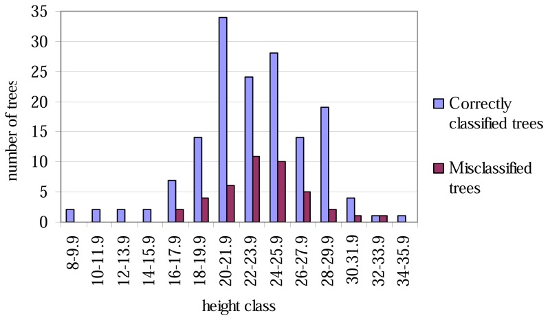
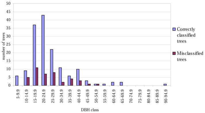
The aim was to use high resolution Aerial Laser Scanning (ALS) data and aerial images to detect European aspen (Populus tremula L.) from among other deciduous trees. The field data consisted of 14 sample plots of 30 m × 30 m size located in the Koli National Park in the North Karelia, Eastern Finland. A Canopy Height Model (CHM) was interpolated from the ALS data with a pulse density of 3.86/m2, low-pass filtered using Height-Based Filtering (HBF) and binarized to create the mask needed to separate the ground pixels from the canopy pixels within individual areas. Watershed segmentation was applied to the low-pass filtered CHM in order to create preliminary canopy segments, from which the non-canopy elements were extracted to obtain the final canopy segmentation, i.e. the ground mask was analysed against the canopy mask. A manual classification of aerial images was employed to separate the canopy segments of deciduous trees from those of coniferous trees. Finally, linear discriminant analysis was applied to the correctly classified canopy segments of deciduous trees to classify them into segments belonging to aspen and those belonging to other deciduous trees. The independent variables used in the classification were obtained from the first pulse ALS point data. The accuracy of discrimination between aspen and other deciduous trees was 78.6%. The independent variables in the classification function were the proportion of vegetation hits, the standard deviation of in pulse heights, accumulated intensity at the 90 percentile and the proportion of laser points reflected at the 60 height percentile. The accuracy of classification corresponded to the validation results of earlier ALS-based studies on the classification of individual deciduous trees to tree species.

摘要

目的是利用高分辨率航空激光扫描(ALS)数据和航空影像从其他落叶树种中检测出欧洲山杨(Populus tremula L.)。实地数据由位于芬兰东部北卡累利阿的科利国家公园内14个大小为30米×30米的样地组成。从脉冲密度为3.86/m²的ALS数据中插值生成冠层高度模型(CHM),使用基于高度的滤波(HBF)进行低通滤波并二值化,以创建在各个区域内将地面像素与冠层像素分离所需的掩码。对低通滤波后的CHM应用分水岭分割以创建初步的冠层片段,从中提取非冠层元素以获得最终的冠层分割,即针对冠层掩码分析地面掩码。采用航空影像的人工分类将落叶树的冠层片段与针叶树的冠层片段区分开来。最后,对正确分类的落叶树冠层片段应用线性判别分析,将其分为属于山杨的片段和属于其他落叶树的片段。分类中使用的自变量从首次脉冲ALS点数据中获取。山杨与其他落叶树之间的判别准确率为78.6%。分类函数中的自变量是植被命中比例、脉冲高度标准差、第90百分位数处的累积强度以及第60高度百分位数处反射的激光点比例。分类准确率与早期基于ALS的将单个落叶树分类到树种的研究的验证结果相符。

https://cdn.ncbi.nlm.nih.gov/pmc/blobs/33ee/3705486/6dbf87b9de41/sensors-08-05037f3.jpg
https://cdn.ncbi.nlm.nih.gov/pmc/blobs/33ee/3705486/bba0fe6f117d/sensors-08-05037f1.jpg
https://cdn.ncbi.nlm.nih.gov/pmc/blobs/33ee/3705486/c11e8e73cfdd/sensors-08-05037f2.jpg
https://cdn.ncbi.nlm.nih.gov/pmc/blobs/33ee/3705486/6dbf87b9de41/sensors-08-05037f3.jpg
https://cdn.ncbi.nlm.nih.gov/pmc/blobs/33ee/3705486/bba0fe6f117d/sensors-08-05037f1.jpg
https://cdn.ncbi.nlm.nih.gov/pmc/blobs/33ee/3705486/c11e8e73cfdd/sensors-08-05037f2.jpg
https://cdn.ncbi.nlm.nih.gov/pmc/blobs/33ee/3705486/6dbf87b9de41/sensors-08-05037f3.jpg

相似文献

1
Detection of Aspens Using High Resolution Aerial Laser Scanning Data and Digital Aerial Images.利用高分辨率航空激光扫描数据和数字航空影像检测白杨
Sensors (Basel). 2008 Aug 25;8(8):5037-5054. doi: 10.3390/s8085037.
2
Species discrimination and individual tree detection for predicting main dendrometric characteristics in mixed temperate forests by use of airborne laser scanning and ultra-high-resolution imagery.利用航空激光扫描和超高分辨率影像进行混合温带森林中树种鉴别和单木检测,以预测主要林分测树学特征。
Sci Total Environ. 2020 Jan 1;698:134074. doi: 10.1016/j.scitotenv.2019.134074. Epub 2019 Sep 2.
3
Object-Based Point Cloud Analysis of Full-Waveform Airborne Laser Scanning Data for Urban Vegetation Classification.基于对象的全波形机载激光扫描数据点云分析用于城市植被分类
Sensors (Basel). 2008 Aug 4;8(8):4505-4528. doi: 10.3390/s8084505.
4
Comparing RIEGL RiCOPTER UAV LiDAR Derived Canopy Height and DBH with Terrestrial LiDAR.比较RIEGL RiCOPTER无人机激光雷达获取的树冠高度和胸径与地面激光雷达的结果。
Sensors (Basel). 2017 Oct 17;17(10):2371. doi: 10.3390/s17102371.
5
Assessing and correcting topographic effects on forest canopy height retrieval using airborne LiDAR data.利用机载激光雷达数据评估和校正地形对森林冠层高度反演的影响。
Sensors (Basel). 2015 May 26;15(6):12133-55. doi: 10.3390/s150612133.
6
Tree parameter extraction in plantation based on airborne LiDAR data.基于机载 LiDAR 数据的人工林树木参数提取。
Ying Yong Sheng Tai Xue Bao. 2024 Feb;35(2):321-329. doi: 10.13287/j.1001-9332.202402.015.
7
Locating chimpanzee nests and identifying fruiting trees with an unmanned aerial vehicle.使用无人机定位黑猩猩巢穴并识别结果树。
Am J Primatol. 2015 Oct;77(10):1122-34. doi: 10.1002/ajp.22446. Epub 2015 Jul 14.
8
Using canopy height model derived from UAV imagery as an auxiliary for spectral data to estimate the canopy cover of mixed broadleaf forests.利用无人机影像生成的冠层高度模型作为光谱数据的辅助手段,估算混交阔叶林的冠层盖度。
Environ Monit Assess. 2021 Dec 27;194(1):45. doi: 10.1007/s10661-021-09695-7.
9
Mapping and characterizing selected canopy tree species at the Angkor World Heritage site in Cambodia using aerial data.利用航空数据对柬埔寨吴哥世界遗产地选定的冠层树种进行测绘和特征描述。
PLoS One. 2015 Apr 22;10(4):e0121558. doi: 10.1371/journal.pone.0121558. eCollection 2015.
10
Mapping Tree Canopy in Urban Environments Using Point Clouds from Airborne Laser Scanning and Street Level Imagery.利用航空激光扫描和街景影像的点云图对城市环境中的树冠进行测绘。
Sensors (Basel). 2022 Apr 24;22(9):3269. doi: 10.3390/s22093269.

引用本文的文献

1
Applied aerial spectroscopy: A case study on remote sensing of an ancient and semi-natural woodland.应用航空光谱学:一个关于古代半天然林地遥感的案例研究
PLoS One. 2021 Nov 15;16(11):e0260056. doi: 10.1371/journal.pone.0260056. eCollection 2021.
2
Absolute radiometric calibration of Als intensity data: effects on accuracy and target classification.Als 强度数据的绝对辐射定标:对精度和目标分类的影响。
Sensors (Basel). 2011;11(11):10586-602. doi: 10.3390/s111110586. Epub 2011 Nov 7.
3
Tree classification with fused mobile laser scanning and hyperspectral data.
基于融合的移动激光扫描和高光谱数据的树木分类。
Sensors (Basel). 2011;11(5):5158-82. doi: 10.3390/s110505158. Epub 2011 May 11.