Molla Yordanos B, Rawlins Barbara, Makanga Prestige Tatenda, Cunningham Marc, Ávila Juan Eugenio Hernández, Ruktanonchai Corrine Warren, Singh Kavita, Alford Sylvia, Thompson Mira, Dwivedi Vikas, Moran Allisyn C, Matthews Zoe
USAID's Maternal and Child Survival Program/Save the Children, Washington, DC, USA.
USAID's Maternal and Child Survival Program/Save the Children, 14136 Grand Pre Rd #34, Silver Spring, MD, Zip: 20906, USA.
BMC Pregnancy Childbirth. 2017 Jan 11;17(1):26. doi: 10.1186/s12884-016-1199-y.
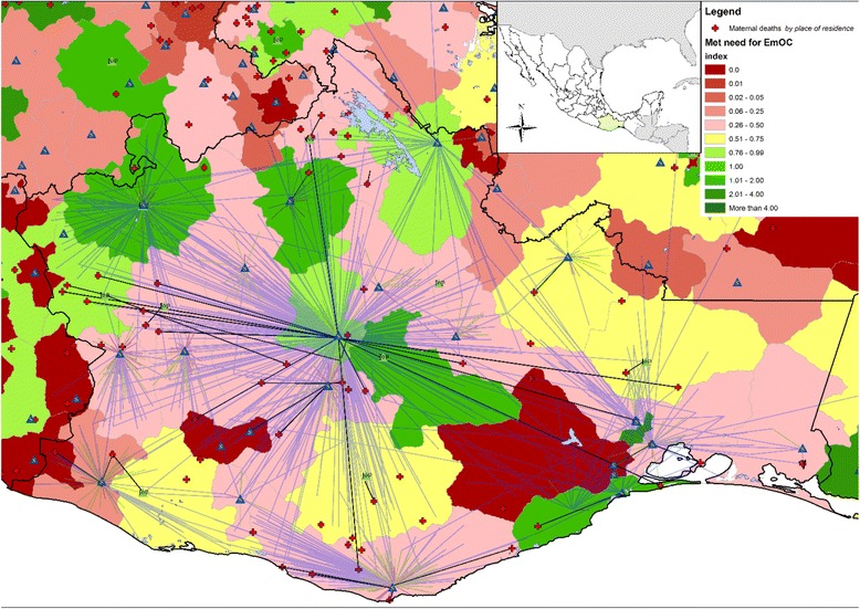
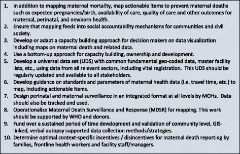
This correspondence argues and offers recommendations for how Geographic Information System (GIS) applied to maternal and newborn health data could potentially be used as part of the broader efforts for ending preventable maternal and newborn mortality. These recommendations were generated from a technical consultation on reporting and mapping maternal deaths that was held in Washington, DC from January 12 to 13, 2015 and hosted by the United States Agency for International Development's (USAID) global Maternal and Child Survival Program (MCSP). Approximately 72 participants from over 25 global health organizations, government agencies, donors, universities, and other groups participated in the meeting.The meeting placed emphases on how improved use of mapping could contribute to the post-2015 United Nation's Sustainable Development Goals (SDGs), agenda in general and to contribute to better maternal and neonatal health outcomes in particular. Researchers and policy makers have been calling for more equitable improvement in Maternal and Newborn Health (MNH), specifically addressing hard-to-reach populations at sub-national levels. Data visualization using mapping and geospatial analyses play a significant role in addressing the emerging need for improved spatial investigation at subnational scale. This correspondence identifies key challenges and recommendations so GIS may be better applied to maternal health programs in resource poor settings. The challenges and recommendations are broadly grouped into three categories: ancillary geospatial and MNH data sources, technical and human resources needs and community participation.
本信函就地理信息系统(GIS)应用于孕产妇和新生儿健康数据如何能够作为消除可预防孕产妇和新生儿死亡的更广泛努力的一部分提出了论点并给出了建议。这些建议源自于2015年1月12日至13日在华盛顿特区举行的一次关于孕产妇死亡报告和绘图的技术磋商会,该会议由美国国际开发署(USAID)的全球孕产妇和儿童生存项目(MCSP)主办。来自25多个全球卫生组织、政府机构、捐助方、大学及其他团体的约72名参与者参加了此次会议。会议重点讨论了改进绘图的使用如何能够总体上有助于2015年后联合国可持续发展目标(SDGs)议程,特别是有助于实现更好的孕产妇和新生儿健康成果。研究人员和政策制定者一直呼吁在孕产妇和新生儿健康(MNH)方面实现更公平的改善,尤其要关注国家以下层面难以触及的人群。使用绘图和地理空间分析进行数据可视化在满足国家以下层面改进空间调查的新需求方面发挥着重要作用。本信函确定了关键挑战和建议,以便GIS能够更好地应用于资源匮乏地区的孕产妇健康项目。这些挑战和建议大致分为三类:辅助地理空间和MNH数据源、技术和人力资源需求以及社区参与。