Atit Kinnari, Weisberg Steven M, Newcombe Nora S, Shipley Thomas F
Department of Psychology, Northwestern University, Evanston, IL 60208 USA ; Department of Psychology, Temple University, Philadelphia, PA 19122 USA.
Center for Cognitive Neuroscience, University of Pennsylvania, Philadelphia, PA 19104 USA ; Department of Psychology, Temple University, Philadelphia, PA 19122 USA.
Cogn Res Princ Implic. 2016;1(1):2. doi: 10.1186/s41235-016-0002-y. Epub 2016 Sep 22.
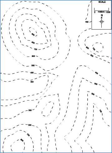
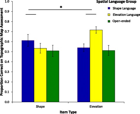
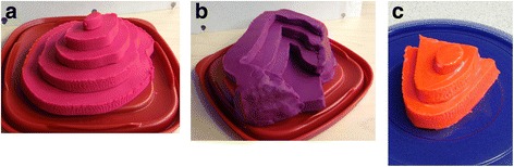
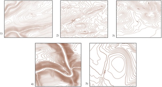
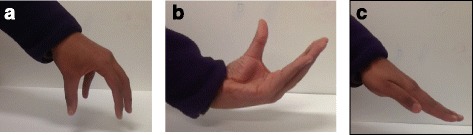
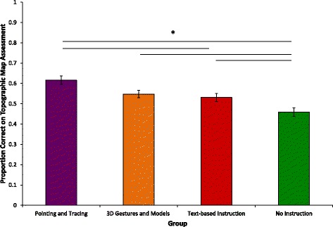
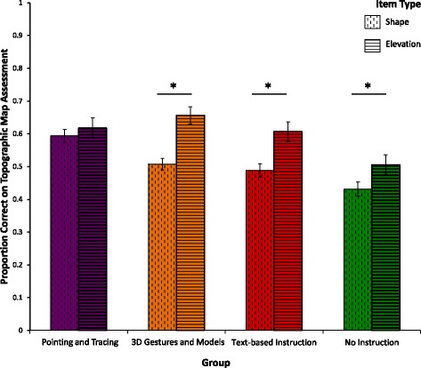
Novices struggle to interpret maps that show information about continuous dimensions (typically latitude and longitude) layered with information that is inherently continuous but segmented categorically. An example is a topographic map, used in earth science disciplines as well as by hikers, emergency rescue operations, and other endeavors requiring knowledge of terrain. Successful comprehension requires understanding that continuous elevation information is categorically encoded using contour lines, as well as skill in visualizing the three-dimensional shape of the terrain from the contour lines. In Experiment 1, we investigated whether novices would benefit from pointing and tracing gestures that focus attention on contour lines and/or from three-dimensional shape gestures used in conjunction with three-dimensional models. Pointing and tracing facilitated understanding relative to text-only instruction as well as no instruction comparison groups, but shape gestures only helped understanding relative to the no instruction comparison group. Directing attention to the contour lines may help both in code breaking (seeing how the lines encode elevation) and in shape inference (seeing how the overall configuration of lines encodes shape). In Experiment 2, we varied the language paired with pointing and tracing gestures; key phrases focused either on elevation information or on visualizing shape. Participants did better on items regarding elevation when language highlighted elevation and better on items requiring shape when language highlighted shape. Thus, focusing attention using pointing and tracing gestures on contour lines may establish the foundation on which language can build to support learning.
新手在解读地图时会遇到困难,这些地图展示的是关于连续维度(通常是纬度和经度)的信息,并叠加了本质上连续但按类别划分的信息。一个例子是地形图,它在地球科学学科以及徒步旅行者、紧急救援行动和其他需要了解地形的活动中都有使用。成功理解需要明白连续的海拔信息是通过等高线进行分类编码的,以及具备从等高线可视化地形三维形状的技能。在实验1中,我们研究了新手是否会从将注意力集中在等高线上的指向和追踪手势,以及与三维模型结合使用的三维形状手势中受益。与仅使用文本的指导组以及无指导对照组相比,指向和追踪有助于理解,但形状手势仅相对于无指导对照组有助于理解。将注意力导向等高线可能在破解编码(了解线条如何编码海拔)和形状推断(了解线条的整体配置如何编码形状)方面都有帮助。在实验2中,我们改变了与指向和追踪手势搭配的语言;关键短语要么侧重于海拔信息,要么侧重于可视化形状。当语言突出海拔时,参与者在关于海拔的项目上表现更好;当语言突出形状时,参与者在需要形状的项目上表现更好。因此,使用指向和追踪手势将注意力集中在等高线上可能为语言支持学习奠定基础。