López Elena, García Sergio, Barea Rafael, Bergasa Luis M, Molinos Eduardo J, Arroyo Roberto, Romera Eduardo, Pardo Samuel
Electronics Department, University of Alcalá, Campus Universitario, 28805 Alcalá de Henares, Spain.
Sensors (Basel). 2017 Apr 8;17(4):802. doi: 10.3390/s17040802.
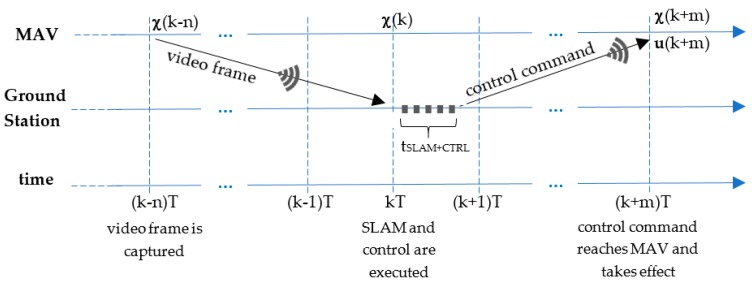
One of the main challenges of aerial robots navigation in indoor or GPS-denied environments is position estimation using only the available onboard sensors. This paper presents a Simultaneous Localization and Mapping (SLAM) system that remotely calculates the pose and environment map of different low-cost commercial aerial platforms, whose onboard computing capacity is usually limited. The proposed system adapts to the sensory configuration of the aerial robot, by integrating different state-of-the art SLAM methods based on vision, laser and/or inertial measurements using an Extended Kalman Filter (EKF). To do this, a minimum onboard sensory configuration is supposed, consisting of a monocular camera, an Inertial Measurement Unit (IMU) and an altimeter. It allows to improve the results of well-known monocular visual SLAM methods (LSD-SLAM and ORB-SLAM are tested and compared in this work) by solving scale ambiguity and providing additional information to the EKF. When payload and computational capabilities permit, a 2D laser sensor can be easily incorporated to the SLAM system, obtaining a local 2.5D map and a footprint estimation of the robot position that improves the 6D pose estimation through the EKF. We present some experimental results with two different commercial platforms, and validate the system by applying it to their position control.
在室内或无全球定位系统(GPS)的环境中,空中机器人导航的主要挑战之一是仅使用机载可用传感器进行位置估计。本文提出了一种同时定位与地图构建(SLAM)系统,该系统可远程计算不同低成本商用空中平台的位姿和环境地图,这些平台的机载计算能力通常有限。所提出的系统通过使用扩展卡尔曼滤波器(EKF)集成基于视觉、激光和/或惯性测量的不同先进SLAM方法,以适应空中机器人的传感配置。为此,假设了一种最小的机载传感配置,包括一个单目相机、一个惯性测量单元(IMU)和一个高度计。它通过解决尺度模糊问题并为EKF提供额外信息,从而改进了著名的单目视觉SLAM方法的结果(本文对LSD-SLAM和ORB-SLAM进行了测试和比较)。当有效载荷和计算能力允许时,二维激光传感器可轻松集成到SLAM系统中,获得局部2.5D地图和机器人位置的足迹估计,通过EKF改进六维位姿估计。我们展示了使用两个不同商用平台的一些实验结果,并通过将系统应用于它们的位置控制来验证该系统。