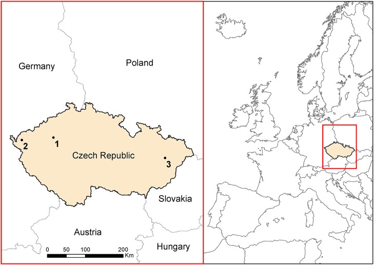
Müllerová Jana, Brůna Josef, Bartaloš Tomáš, Dvořák Petr, Vítková Michaela, Pyšek Petr
Institute of Botany, The Czech Academy of SciencesPrůhonice, Czechia.
Faculty of Science, Institute for Environmental Studies, Charles UniversityPrague, Czechia.
Front Plant Sci. 2017 May 31;8:887. doi: 10.3389/fpls.2017.00887. eCollection 2017.
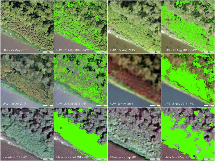
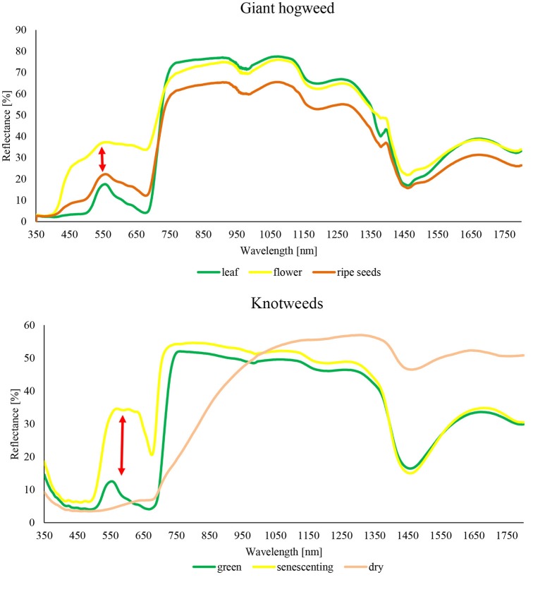
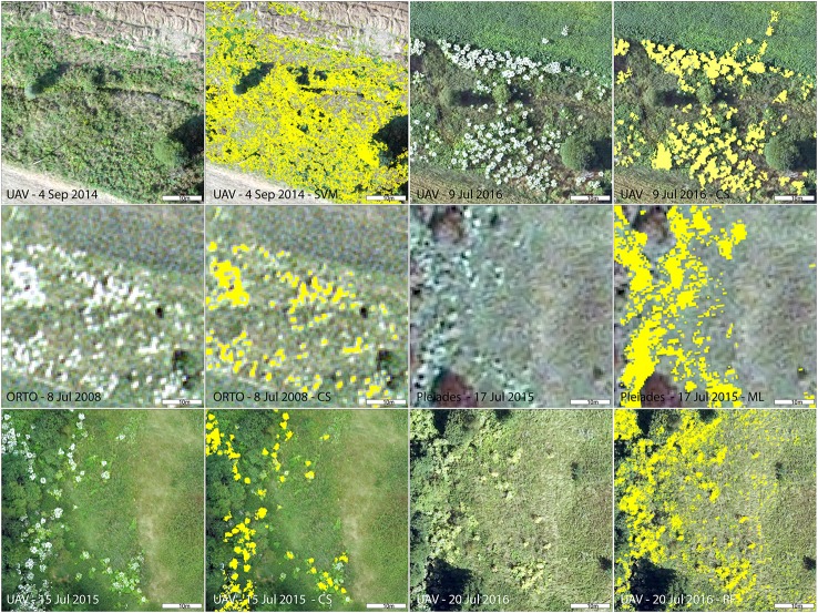
The rapid spread of invasive plants makes their management increasingly difficult. Remote sensing offers a means of fast and efficient monitoring, but still the optimal methodologies remain to be defined. The seasonal dynamics and spectral characteristics of the target invasive species are important factors, since, at certain time of the vegetation season (e.g., at flowering or senescing), plants are often more distinct (or more visible beneath the canopy). Our aim was to establish fast, repeatable and a cost-efficient, computer-assisted method applicable over larger areas, to reduce the costs of extensive field campaigns. To achieve this goal, we examined how the timing of monitoring affects the detection of noxious plant invaders in Central Europe, using two model herbaceous species with markedly different phenological, structural, and spectral characteristics. They are giant hogweed (), a species with very distinct flowering phase, and the less distinct knotweeds (, and their hybrid . × ). The variety of data generated, such as imagery from purposely-designed, unmanned aircraft vehicle (UAV), and VHR satellite, and aerial color orthophotos enabled us to assess the effects of spectral, spatial, and temporal resolution (i.e., the target species' phenological state) for successful recognition. The demands for both spatial and spectral resolution depended largely on the target plant species. In the case that a species was sampled at the most distinct phenological phase, high accuracy was achieved even with lower spectral resolution of our low-cost UAV. This demonstrates that proper timing can to some extent compensate for the lower spectral resolution. The results of our study could serve as a basis for identifying priorities for management, targeted at localities with the greatest risk of invasive species' spread and, once eradicated, to monitor over time any return. The best mapping strategy should reflect morphological and structural features of the target plant and choose appropriate spatial, spectral, and temporal resolution. The UAV enables flexible data acquisition for required time periods at low cost and is, therefore, well-suited for targeted monitoring; while satellite imagery provides the best solution for larger areas. Nonetheless, users must be aware of their limits.
入侵植物的迅速蔓延使得对它们的管理愈发困难。遥感提供了一种快速高效的监测手段,但最佳方法仍有待确定。目标入侵物种的季节动态和光谱特征是重要因素,因为在植被季节的特定时间(例如开花或衰老时),植物通常更加独特(或在树冠下更易可见)。我们的目标是建立一种快速、可重复且成本效益高的计算机辅助方法,该方法适用于更大区域,以降低大规模野外调查的成本。为实现这一目标,我们使用两种具有明显不同物候、结构和光谱特征的草本植物模型,研究了监测时间对中欧有害植物入侵者检测的影响。它们是大豕草(一种具有非常明显开花期的物种)和不太明显的蓼属植物(和它们的杂交种. × )。生成的各种数据,如来自专门设计的无人机(UAV)、高分辨率卫星的图像以及航空彩色正射影像,使我们能够评估光谱、空间和时间分辨率(即目标物种的物候状态)对成功识别的影响。对空间和光谱分辨率的要求在很大程度上取决于目标植物物种。如果在最明显的物候阶段对一个物种进行采样,即使使用我们低成本无人机的较低光谱分辨率也能实现高精度。这表明合适的时间在一定程度上可以弥补较低的光谱分辨率。我们的研究结果可作为确定管理重点的基础,针对入侵物种传播风险最大的地区,一旦根除,还可长期监测是否有复发。最佳的测绘策略应反映目标植物的形态和结构特征,并选择合适的空间、光谱和时间分辨率。无人机能够以低成本在所需时间段内灵活采集数据,因此非常适合进行有针对性的监测;而卫星图像为更大区域提供了最佳解决方案。尽管如此,用户必须清楚它们的局限性。