Sallam Mohamed F, Michaels Sarah R, Riegel Claudia, Pereira Roberto M, Zipperer Wayne, Lockaby B Graeme, Koehler Philip G
Department/School Entomology and Nematology Department, University of Florida, Gainesville, FL 32611, USA.
College of Science, Ain Shams University, Cairo 11566, Egypt.
Int J Environ Res Public Health. 2017 Aug 8;14(8):892. doi: 10.3390/ijerph14080892.
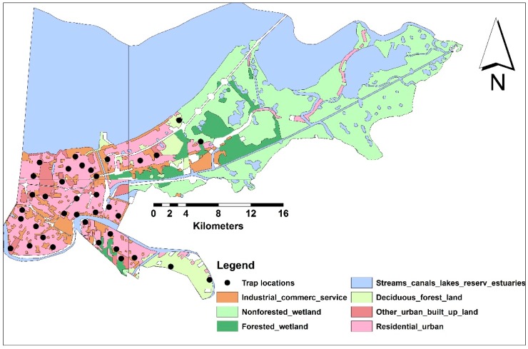
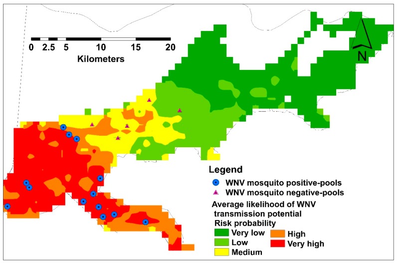
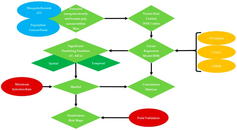
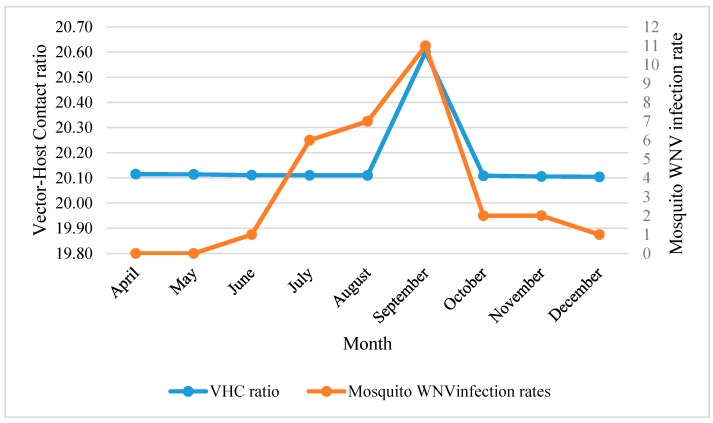
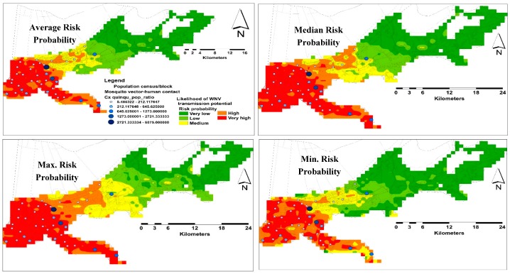
The consistent sporadic transmission of West Nile Virus (WNV) in the city of New Orleans justifies the need for distribution risk maps highlighting human risk of mosquito bites. We modeled the influence of biophysical and socioeconomic metrics on the spatio-temporal distributions of presence/vector-host contact (VHC) ratios of WNV vector, , within their flight range Biophysical and socioeconomic data were extracted within 5-km buffer radii around sampling localities of gravid female . The spatio-temporal correlations between VHC data and 33 variables, including climate, land use-land cover (LULC), socioeconomic, and land surface terrain were analyzed using stepwise linear regression models (RM). Using MaxEnt, we developed a distribution model using the correlated predicting variables. Only 12 factors showed significant correlations with spatial distribution of VHC ratios (² = 81.62, < 0.01). Non-forested wetland (NFWL), tree density (TD) and residential-urban (RU) settings demonstrated the strongest relationship. The VHC ratios showed monthly environmental resilience in terms of number and type of influential factors. The highest prediction power of RU and other urban and built up land (OUBL), was demonstrated during May-August. This association was positively correlated with the onset of the mosquito WNV infection rate during June. These findings were confirmed by the Jackknife analysis in MaxEnt and independently collected field validation points. The spatial and temporal correlations of VHC ratios and their response to the predicting variables are discussed.
西尼罗河病毒(WNV)在新奥尔良市持续散发传播,这表明有必要绘制风险分布图,突出显示人类被蚊子叮咬的风险。我们模拟了生物物理和社会经济指标对WNV媒介在其飞行范围内的时空分布以及存在/媒介-宿主接触(VHC)比率的影响。在采集孕蚊样本地点周围5公里缓冲半径范围内提取生物物理和社会经济数据。使用逐步线性回归模型(RM)分析了VHC数据与33个变量之间的时空相关性,这些变量包括气候、土地利用-土地覆盖(LULC)、社会经济和地表地形。我们使用MaxEnt,利用相关的预测变量开发了一个分布模型。只有12个因素与VHC比率的空间分布显示出显著相关性(² = 81.62,< 0.01)。非森林湿地(NFWL)、树木密度(TD)和城市居民区(RU)环境显示出最强的相关性。VHC比率在影响因素的数量和类型方面表现出月度环境适应性。RU以及其他城市和建成区土地(OUBL)在5月至8月期间表现出最高的预测能力。这种关联与6月蚊子WNV感染率的上升呈正相关。这些发现通过MaxEnt中的刀切法分析以及独立收集的现场验证点得到了证实。本文讨论了VHC比率的时空相关性及其对预测变量的响应。