Tlou Boikhutso, Sartorius Benn, Tanser Frank
Discipline of Public Health Medicine, School of Nursing and Public Health, University of KwaZulu-Natal, Durban, South Africa.
Africa Centre for Health and Population Studies, University of KwaZulu-Natal, Mtubatuba, South Africa.
PLoS One. 2017 Aug 24;12(8):e0182478. doi: 10.1371/journal.pone.0182478. eCollection 2017.
The aim of the study was to identify the key determinants of child mortality 'hot-spots' in space and time.
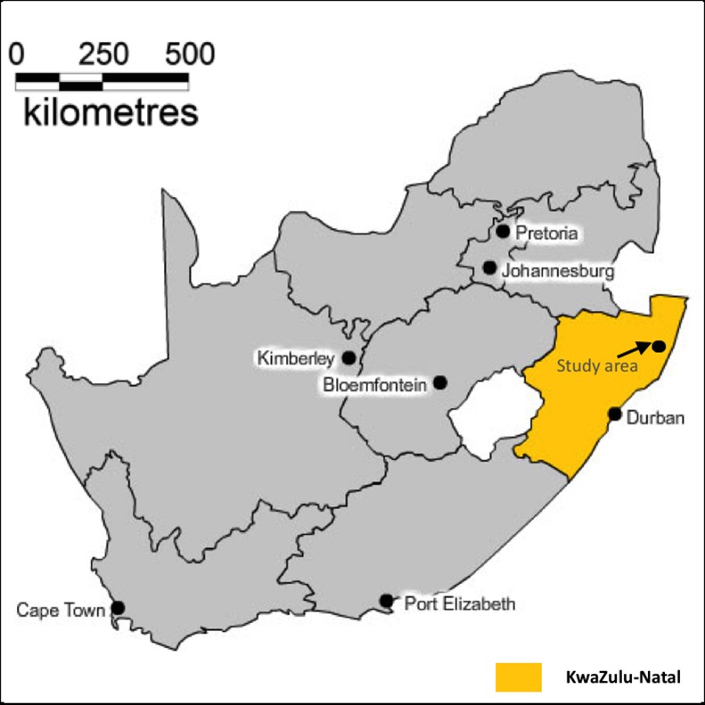
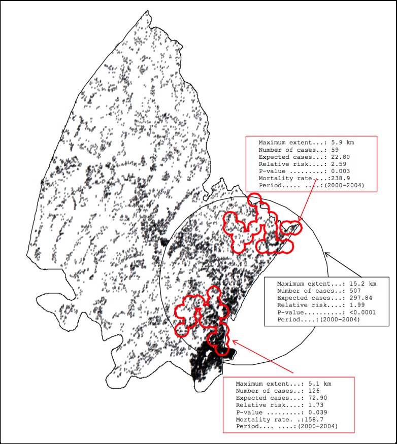
Comprehensive population-based mortality data collected between 2000 and 2014 by the Africa Centre Demographic Information System located in the UMkhanyakude District of KwaZulu-Natal Province, South Africa, was analysed. We assigned all mortality events and person-time of observation for children <5 years of age to an exact homestead of residence (mapped to <2m accuracy as part of the DSA platform). Using these exact locations, both the Kulldorff and Tango spatial scan statistics for regular and irregular shaped cluster detection were used to identify clusters of childhood mortality events in both space and time.
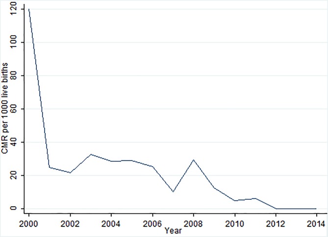
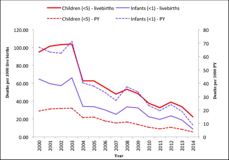
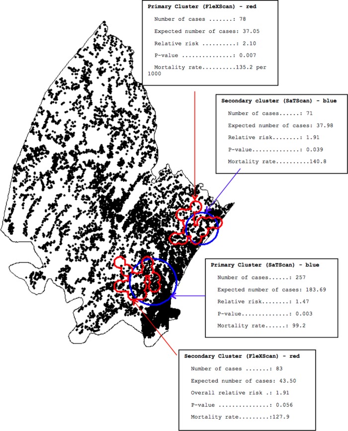
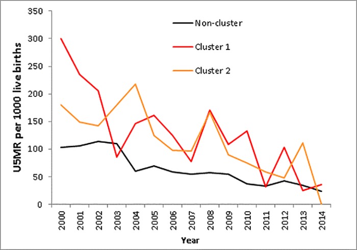
Of the 49 986 children aged < 5 years who resided in the study area between 2000 and 2014, 2010 (4.0%) died. Childhood mortality decreased by 80% over the period from >20 per 1000 person-years in 2001-2003 to 4 per 1000 person-years in 2014. The two scanning spatial techniques identified two high-risk clusters for child mortality along the eastern border of the study site near the national highway, with a relative risk of 2.10 and 1.91 respectively.
The high-risk communities detected in this work, and the differential risk factor profile of these communities, can assist public health professionals to identify similar populations in other parts of rural South Africa. Identifying child mortality hot-spots will potentially guide policy interventions in rural, resource-limited settings.
本研究旨在确定儿童死亡率“热点地区”在空间和时间上的关键决定因素。
对位于南非夸祖鲁-纳塔尔省乌姆卡尼亚库德区的非洲人口信息系统在2000年至2014年期间收集的基于人群的综合死亡率数据进行了分析。我们将所有5岁以下儿童的死亡事件和观察人时分配到确切的居住家园(作为DSA平台的一部分,地图精度<2米)。利用这些精确位置,采用用于常规和不规则形状聚类检测的Kulldorff和Tango空间扫描统计方法,来识别儿童死亡事件在空间和时间上的聚类情况。
在2000年至2014年居住在研究区域的49986名5岁以下儿童中,有2010名(4.0%)死亡。儿童死亡率在该时期从2001 - 2003年每1000人年超过20例下降到2014年的每1000人年4例,降幅达80%。这两种扫描空间技术在靠近国道的研究地点东部边界识别出两个儿童死亡高风险聚类,相对风险分别为2.10和1.91。
本研究中检测到的高风险社区以及这些社区不同的风险因素特征,可帮助公共卫生专业人员识别南非农村其他地区的类似人群。识别儿童死亡率热点地区可能会指导农村资源有限地区的政策干预。