Rood Ente J J, Goris Marga G A, Pijnacker Roan, Bakker Mirjam I, Hartskeerl Rudy A
KIT Royal Tropical Institute, Health dept., Amsterdam, The Netherlands.
WHO/FAO/OIE and National Collaborating Centre for Reference and Research on Leptospirosis, Amsterdam, The Netherlands.
PLoS One. 2017 Oct 24;12(10):e0186987. doi: 10.1371/journal.pone.0186987. eCollection 2017.
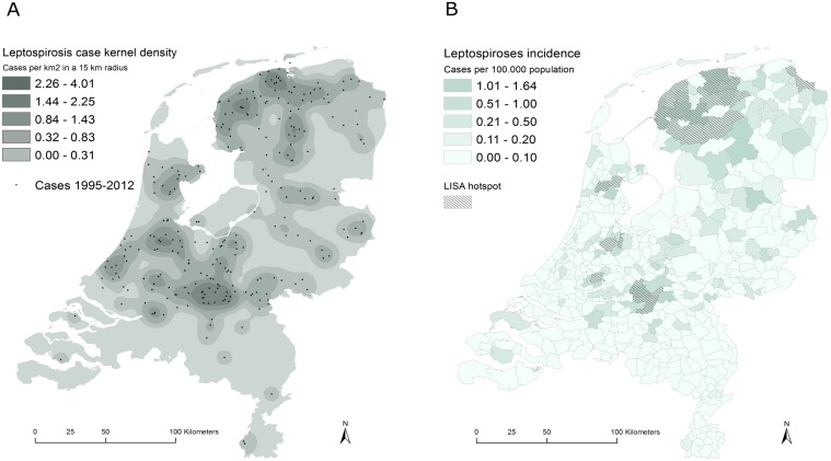
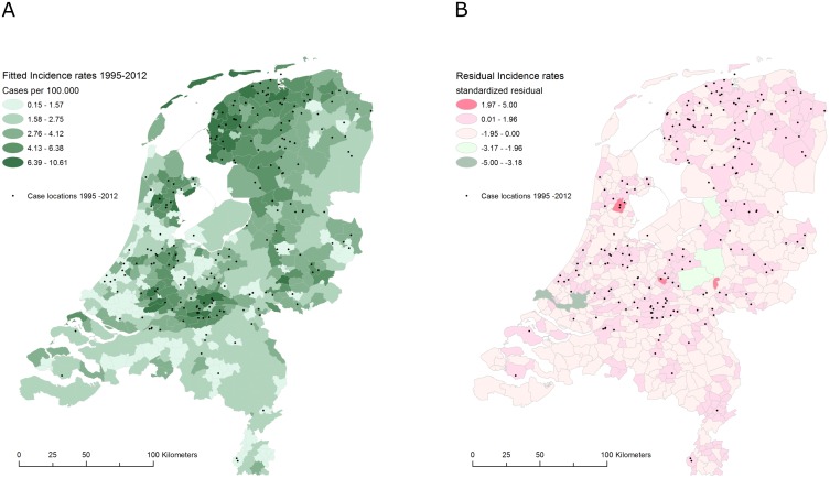
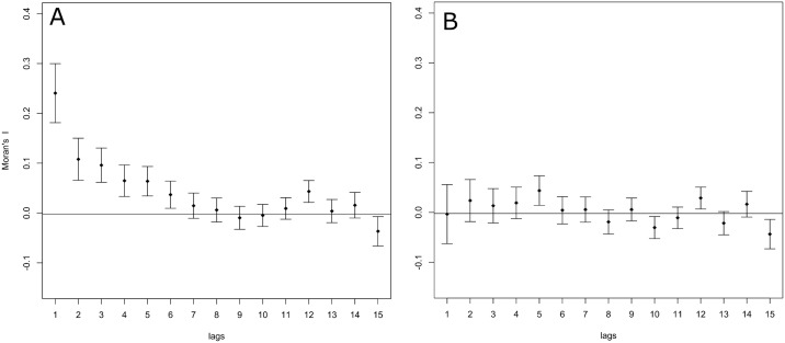
Leptospirosis is a globally emerging zoonotic disease, associated with various climatic, biotic and abiotic factors. Mapping and quantifying geographical variations in the occurrence of leptospirosis and the surrounding environment offer innovative methods to study disease transmission and to identify associations between the disease and the environment. This study aims to investigate geographic variations in leptospirosis incidence in the Netherlands and to identify associations with environmental factors driving the emergence of the disease. Individual case data derived over the period 1995-2012 in the Netherlands were geocoded and aggregated by municipality. Environmental covariate data were extracted for each municipality and stored in a spatial database. Spatial clusters were identified using kernel density estimations and quantified using local autocorrelation statistics. Associations between the incidence of leptospirosis and the local environment were determined using Simultaneous Autoregressive Models (SAR) explicitly modelling spatial dependence of the model residuals. Leptospirosis incidence rates were found to be spatially clustered, showing a marked spatial pattern. Fitting a spatial autoregressive model significantly improved model fit and revealed significant association between leptospirosis and the coverage of arable land, built up area, grassland and sabulous clay soils. The incidence of leptospirosis in the Netherlands could effectively be modelled using a combination of soil and land-use variables accounting for spatial dependence of incidence rates per municipality. The resulting spatially explicit risk predictions provide an important source of information which will benefit clinical awareness on potential leptospirosis infections in endemic areas.
钩端螺旋体病是一种在全球范围内新出现的人畜共患病,与各种气候、生物和非生物因素相关。绘制和量化钩端螺旋体病发生情况及其周边环境的地理差异,为研究疾病传播以及识别疾病与环境之间的关联提供了创新方法。本研究旨在调查荷兰钩端螺旋体病发病率的地理差异,并确定与驱动该病出现的环境因素之间的关联。对1995年至2012年期间荷兰的个体病例数据进行地理编码,并按市镇进行汇总。提取每个市镇的环境协变量数据并存储在空间数据库中。使用核密度估计识别空间聚类,并使用局部自相关统计进行量化。使用同时自回归模型(SAR)明确模拟模型残差的空间依赖性,确定钩端螺旋体病发病率与当地环境之间的关联。发现钩端螺旋体病发病率在空间上呈聚类分布,呈现出明显的空间格局。拟合空间自回归模型显著改善了模型拟合,并揭示了钩端螺旋体病与耕地覆盖、建成区、草地和沙质粘土之间的显著关联。利用考虑各市镇发病率空间依赖性的土壤和土地利用变量组合,可以有效地模拟荷兰钩端螺旋体病的发病率。由此产生的空间明确风险预测提供了重要的信息来源,将有助于提高对流行地区潜在钩端螺旋体感染的临床认识。