Saunders Megan Irene, Atkinson Scott, Klein Carissa Joy, Weber Tony, Possingham Hugh P
Centre for Biodiversity and Conservation Science, The University of Queensland, St. Lucia, QLD, Australia.
Australian Research Council (ARC) Centre of Excellence in Environmental Decisions, The University of Queensland, St Lucia, QLD, Australia.
PLoS One. 2017 Nov 10;12(11):e0187284. doi: 10.1371/journal.pone.0187284. eCollection 2017.
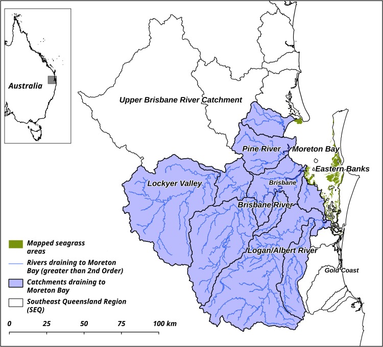
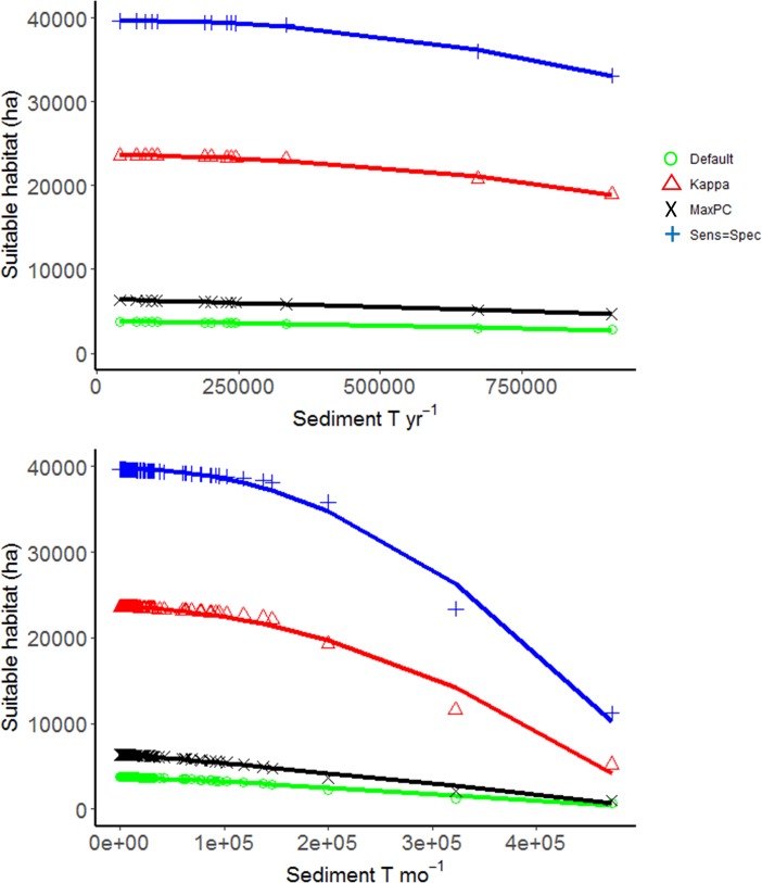
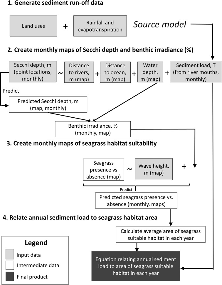
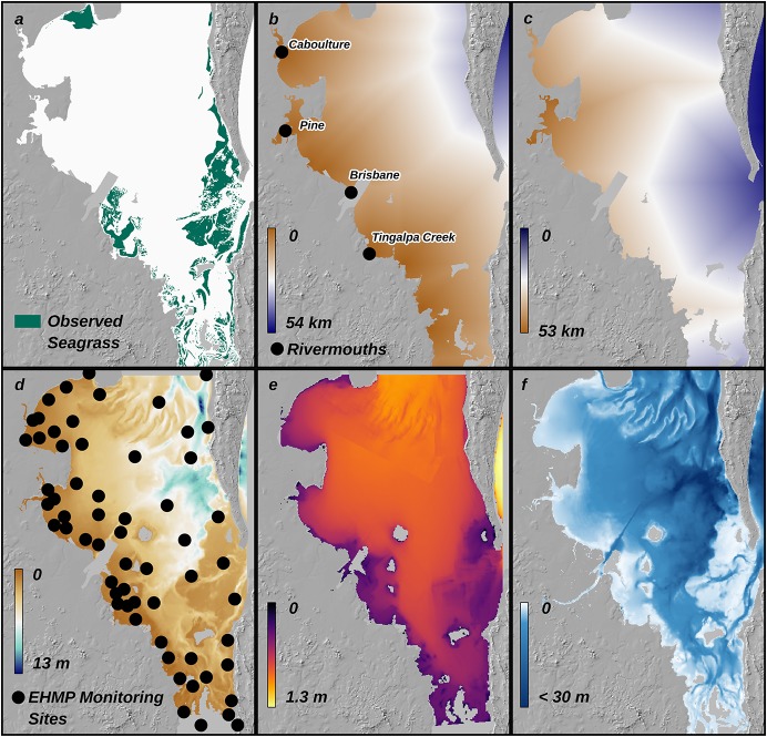
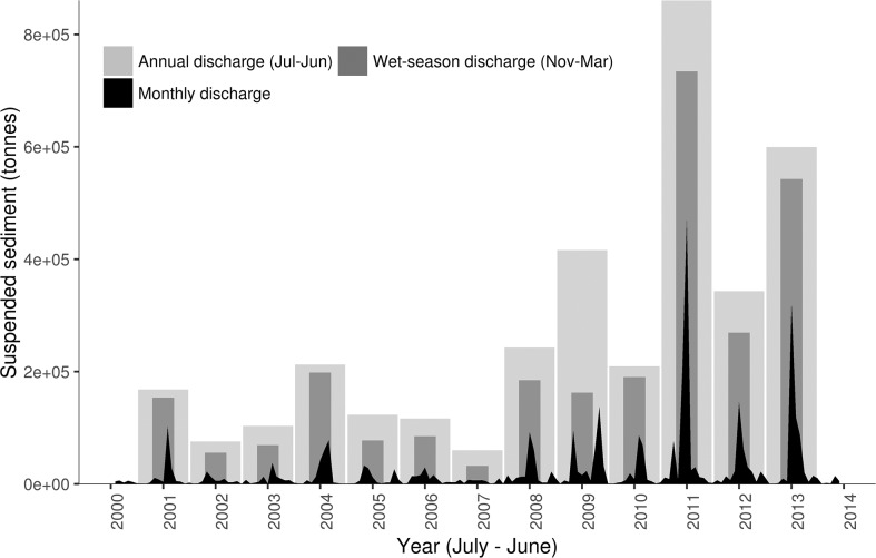
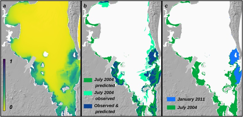
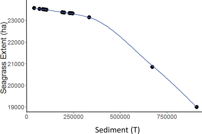
Land-based activities, including deforestation, agriculture, and urbanisation, cause increased erosion, reduced inland and coastal water quality, and subsequent loss or degradation of downstream coastal marine ecosystems. Quantitative approaches to link sediment loads from catchments to metrics of downstream marine ecosystem state are required to calculate the cost effectiveness of taking conservation actions on land to benefits accrued in the ocean. Here we quantify the relationship between sediment loads derived from landscapes to habitat suitability of seagrass meadows in Moreton Bay, Queensland, Australia. We use the following approach: (1) a catchment hydrological model generates sediment loads; (2) a statistical model links sediment loads to water clarity at monthly time-steps; (3) a species distribution model (SDM) factors in water clarity, bathymetry, wave height, and substrate suitability to predict seagrass habitat suitability at monthly time-steps; and (4) a statistical model quantifies the effect of sediment loads on area of seagrass suitable habitat in a given year. The relationship between sediment loads and seagrass suitable habitat is non-linear: large increases in sediment have a disproportionately large negative impact on availability of seagrass suitable habitat. Varying the temporal scale of analysis (monthly vs. yearly), or varying the threshold value used to delineate predicted seagrass presence vs. absence, both affect the magnitude, but not the overall shape, of the relationship between sediment loads and seagrass suitable habitat area. Quantifying the link between sediment produced from catchments and extent of downstream marine ecosystems allows assessment of the relative costs and benefits of taking conservation actions on land or in the ocean, respectively, to marine ecosystems.
包括森林砍伐、农业和城市化在内的陆地活动,导致侵蚀加剧、内陆和沿海水质下降,进而造成下游沿海海洋生态系统的丧失或退化。需要采用定量方法将流域的沉积物负荷与下游海洋生态系统状态指标联系起来,以计算在陆地采取保护行动对海洋所获效益的成本效益。在此,我们量化了澳大利亚昆士兰州莫顿湾源自陆地景观的沉积物负荷与海草草甸栖息地适宜性之间的关系。我们采用以下方法:(1) 一个流域水文模型生成沉积物负荷;(2) 一个统计模型将沉积物负荷与每月时间步长的水体透明度联系起来;(3) 一个物种分布模型(SDM)将水体透明度、水深、波高和底物适宜性作为因素,以预测每月时间步长的海草栖息地适宜性;(4) 一个统计模型量化沉积物负荷对给定年份海草适宜栖息地面积的影响。沉积物负荷与海草适宜栖息地之间的关系是非线性的:沉积物的大幅增加对海草适宜栖息地的可用性产生不成比例的巨大负面影响。改变分析的时间尺度(每月与每年),或改变用于划定预测海草存在与否的阈值,都会影响沉积物负荷与海草适宜栖息地面积之间关系的幅度,但不影响其总体形状。量化流域产生的沉积物与下游海洋生态系统范围之间的联系,有助于分别评估在陆地或海洋采取保护行动对海洋生态系统的相对成本和效益。