Winton R Scott, Ocampo-Peñuela Natalia, Cagle Nicolette
Department of Environmental Systems Science, ETH Zurich, Zurich, Switzerland.
Nicholas School of the Environment, Duke University, Durham, NC, United States of America.
PeerJ. 2018 Jan 4;6:e4215. doi: 10.7717/peerj.4215. eCollection 2018.
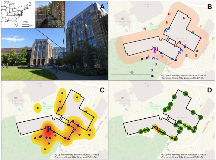
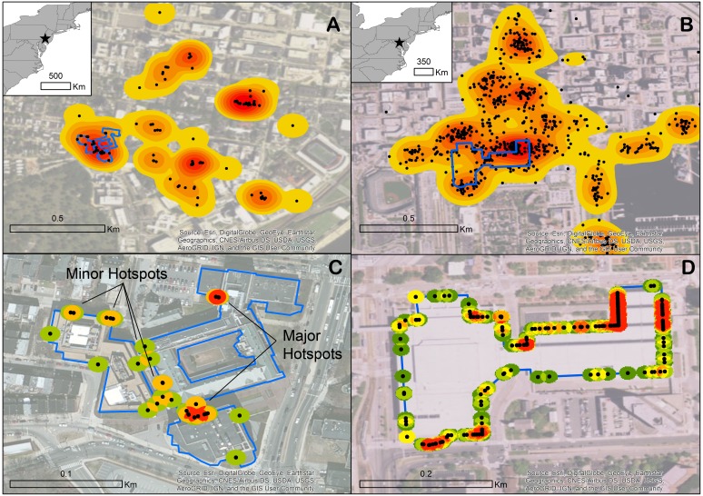
Bird collisions with windows are an important conservation concern. Efficient mitigation efforts should prioritize retrofitting sections of glass exhibiting the highest mortality of birds. Most collision studies, however, record location meta-data at a spatial scale too coarse (i.e., compass direction of facing façade) to be useful for large buildings with complex geometries. Through spatial analysis of three seasons of survey data at a large building at a university campus, we found that GPS data were able to identify collision hotspots while compass directions could not. To demonstrate the broad applicability and utility of this georeferencing approach, we identified collision hotspots at two additional urban areas in North America. The data for this latter exercise were collected via the citizen science database, iNaturalist, which we review for its potential to generate the georeferenced data necessary for directing building retrofits and mitigating a major source of anthropogenic bird mortality.
鸟类与窗户碰撞是一个重要的保护问题。有效的缓解措施应优先改造鸟类死亡率最高的玻璃区域。然而,大多数碰撞研究记录的位置元数据空间尺度过于粗糙(即正面外墙的罗盘方向),对于几何形状复杂的大型建筑来说并无用处。通过对大学校园一座大型建筑三个季节的调查数据进行空间分析,我们发现全球定位系统(GPS)数据能够识别碰撞热点,而罗盘方向则无法做到。为了证明这种地理参考方法的广泛适用性和实用性,我们在北美另外两个城市地区识别出了碰撞热点。后一项研究的数据是通过公民科学数据库iNaturalist收集的,我们评估了该数据库生成指导建筑改造和减轻人为鸟类死亡主要来源所需地理参考数据的潜力。