• 文献检索
  • 文档翻译
  • 深度研究
  • 学术资讯
  • Suppr Zotero 插件Zotero 插件
  • 邀请有礼
  • 套餐&价格
  • 历史记录
应用&插件
Suppr Zotero 插件Zotero 插件浏览器插件Mac 客户端Windows 客户端微信小程序
定价
高级版会员购买积分包购买API积分包
服务
文献检索文档翻译深度研究API 文档MCP 服务
关于我们
关于 Suppr公司介绍联系我们用户协议隐私条款
关注我们

Suppr 超能文献

核心技术专利:CN118964589B侵权必究
粤ICP备2023148730 号-1Suppr @ 2026

文献检索

告别复杂PubMed语法,用中文像聊天一样搜索,搜遍4000万医学文献。AI智能推荐,让科研检索更轻松。

立即免费搜索

文件翻译

保留排版,准确专业,支持PDF/Word/PPT等文件格式,支持 12+语言互译。

免费翻译文档

深度研究

AI帮你快速写综述,25分钟生成高质量综述,智能提取关键信息,辅助科研写作。

立即免费体验

基于定标利用高分一号宽视场(WFV)影像进行宽条带立体测绘

Wide Swath Stereo Mapping from Gaofen-1 Wide-Field-View (WFV) Images Using Calibration.

作者信息

Chen Shoubin, Liu Jingbin, Huang Wenchao, Chen Ruizhi

机构信息

State Key Laboratory of Information Engineering in Surveying, Mapping and Remote Sensing, Wuhan University, Wuhan 430079, China.

Collaborative Innovation Center of Geospatial Technology, Wuhan University, Wuhan 430079, China.

出版信息

Sensors (Basel). 2018 Mar 1;18(3):739. doi: 10.3390/s18030739.

DOI:10.3390/s18030739
PMID:29494540
原文链接:https://pmc.ncbi.nlm.nih.gov/articles/PMC5876903/
Abstract

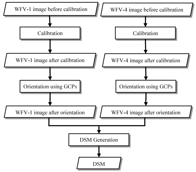
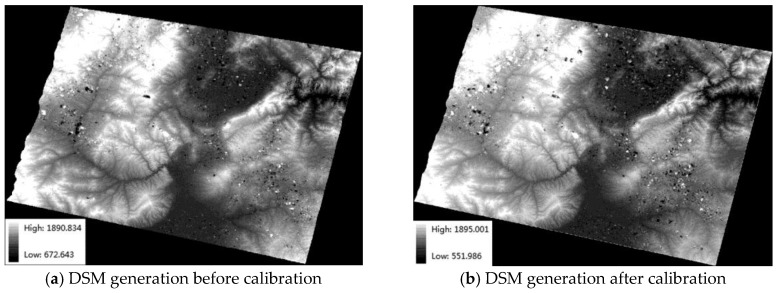
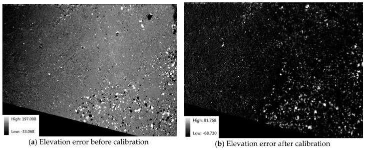
The development of Earth observation systems has changed the nature of survey and mapping products, as well as the methods for updating maps. Among optical satellite mapping methods, the multiline array stereo and agile stereo modes are the most common methods for acquiring stereo images. However, differences in temporal resolution and spatial coverage limit their application. In terms of this issue, our study takes advantage of the wide spatial coverage and high revisit frequencies of wide swath images and aims at verifying the feasibility of stereo mapping with the wide swath stereo mode and reaching a reliable stereo accuracy level using calibration. In contrast with classic stereo modes, the wide swath stereo mode is characterized by both a wide spatial coverage and high-temporal resolution and is capable of obtaining a wide range of stereo images over a short period. In this study, Gaofen-1 (GF-1) wide-field-view (WFV) images, with total imaging widths of 800 km, multispectral resolutions of 16 m and revisit periods of four days, are used for wide swath stereo mapping. To acquire a high-accuracy digital surface model (DSM), the nonlinear system distortion in the GF-1 WFV images is detected and compensated for in advance. The elevation accuracy of the wide swath stereo mode of the GF-1 WFV images can be improved from 103 m to 30 m for a DSM with proper calibration, meeting the demands for 1:250,000 scale mapping and rapid topographic map updates and showing improved efficacy for satellite imaging.

摘要

地球观测系统的发展改变了测绘产品的性质以及地图更新方法。在光学卫星测绘方法中,多线阵立体和敏捷立体模式是获取立体图像最常用的方法。然而,时间分辨率和空间覆盖范围的差异限制了它们的应用。针对这一问题,我们的研究利用宽幅图像的广泛空间覆盖和高重访频率,旨在验证宽幅立体模式进行立体测绘的可行性,并通过校准达到可靠的立体精度水平。与经典立体模式相比,宽幅立体模式具有广泛的空间覆盖和高时间分辨率的特点,能够在短时间内获取大范围的立体图像。在本研究中,高分一号(GF-1)宽视场(WFV)图像用于宽幅立体测绘,其总成像宽度为800公里,多光谱分辨率为16米,重访周期为四天。为了获取高精度数字表面模型(DSM),预先检测并补偿了GF-1 WFV图像中的非线性系统畸变。对于经过适当校准的DSM,GF-1 WFV图像宽幅立体模式的高程精度可从103米提高到30米,满足1:250,000比例尺测绘和快速地形图更新的要求,并显示出卫星成像的更高效率。

https://cdn.ncbi.nlm.nih.gov/pmc/blobs/07d3/5876903/66ea86c89c77/sensors-18-00739-g012.jpg
https://cdn.ncbi.nlm.nih.gov/pmc/blobs/07d3/5876903/62c0e05af911/sensors-18-00739-g001.jpg
https://cdn.ncbi.nlm.nih.gov/pmc/blobs/07d3/5876903/4f6337293426/sensors-18-00739-g002.jpg
https://cdn.ncbi.nlm.nih.gov/pmc/blobs/07d3/5876903/6482da421ae4/sensors-18-00739-g003.jpg
https://cdn.ncbi.nlm.nih.gov/pmc/blobs/07d3/5876903/15d8fafc68b4/sensors-18-00739-g004.jpg
https://cdn.ncbi.nlm.nih.gov/pmc/blobs/07d3/5876903/c16bd65223c8/sensors-18-00739-g005.jpg
https://cdn.ncbi.nlm.nih.gov/pmc/blobs/07d3/5876903/fa973f1f187b/sensors-18-00739-g006a.jpg
https://cdn.ncbi.nlm.nih.gov/pmc/blobs/07d3/5876903/a01d745e0b6a/sensors-18-00739-g007.jpg
https://cdn.ncbi.nlm.nih.gov/pmc/blobs/07d3/5876903/5dcf9301a5a5/sensors-18-00739-g008.jpg
https://cdn.ncbi.nlm.nih.gov/pmc/blobs/07d3/5876903/cea2957696f0/sensors-18-00739-g009.jpg
https://cdn.ncbi.nlm.nih.gov/pmc/blobs/07d3/5876903/39c8bf8880ec/sensors-18-00739-g010.jpg
https://cdn.ncbi.nlm.nih.gov/pmc/blobs/07d3/5876903/49fc1a80ff0d/sensors-18-00739-g011.jpg
https://cdn.ncbi.nlm.nih.gov/pmc/blobs/07d3/5876903/66ea86c89c77/sensors-18-00739-g012.jpg

相似文献

1
Wide Swath Stereo Mapping from Gaofen-1 Wide-Field-View (WFV) Images Using Calibration.基于定标利用高分一号宽视场(WFV)影像进行宽条带立体测绘
Sensors (Basel). 2018 Mar 1;18(3):739. doi: 10.3390/s18030739.
2
DSM Extraction Based on Gaofen-6 Satellite High-Resolution Cross-Track Images with Wide Field of View.基于高分六号卫星宽幅高分辨率沿轨立体影像的 DSM 提取
Sensors (Basel). 2023 Mar 27;23(7):3497. doi: 10.3390/s23073497.
3
Atmospheric Correction of Satellite GF-1/WFV Imagery and Quantitative Estimation of Suspended Particulate Matter in the Yangtze Estuary.卫星GF-1/WFV影像的大气校正及长江口悬浮颗粒物定量反演
Sensors (Basel). 2016 Nov 25;16(12):1997. doi: 10.3390/s16121997.
4
Combining HJ CCD, GF-1 WFV and MODIS Data to Generate Daily High Spatial Resolution Synthetic Data for Environmental Process Monitoring.结合HJ CCD、GF-1 WFV和MODIS数据生成用于环境过程监测的每日高空间分辨率合成数据。
Int J Environ Res Public Health. 2015 Aug 20;12(8):9920-37. doi: 10.3390/ijerph120809920.
5
A Learning-Enhanced Two-Pair Spatiotemporal Reflectance Fusion Model for GF-2 and GF-1 WFV Satellite Data.一种用于高分二号和高分一号宽幅相机卫星数据的学习增强型双对时空反射率融合模型。
Sensors (Basel). 2020 Mar 24;20(6):1789. doi: 10.3390/s20061789.
6
ScanSAR Interferometry of the Gaofen-3 Satellite with Unsynchronized Repeat-Pass Images.高分三号卫星非同步重复轨道 SAR 干涉处理。
Sensors (Basel). 2019 Oct 28;19(21):4689. doi: 10.3390/s19214689.
7
Estimation of Daily Terrestrial Latent Heat Flux with High Spatial Resolution from MODIS and Chinese GF-1 Data.利用 MODIS 和中国 GF-1 数据高空间分辨率估算逐日陆面潜热通量。
Sensors (Basel). 2020 May 15;20(10):2811. doi: 10.3390/s20102811.
8
Polarimetric Calibration and Quality Assessment of the GF-3 Satellite Images.高分三号卫星影像的极化定标与质量评估
Sensors (Basel). 2018 Jan 30;18(2):403. doi: 10.3390/s18020403.
9
Leaf Area Index Estimation Using Chinese GF-1 Wide Field View Data in an Agriculture Region.利用中国 GF-1 宽视场数据估算农业区叶面积指数。
Sensors (Basel). 2017 Jul 8;17(7):1593. doi: 10.3390/s17071593.
10
Comparison of CBERS-04, GF-1, and GF-2 Satellite Panchromatic Images for Mapping Quasi-Circular Vegetation Patches in the Yellow River Delta, China.比较中巴地球资源卫星 04 星、高分一号和高分二号全色影像在黄河三角洲准圆环状植被斑块制图中的应用。
Sensors (Basel). 2018 Aug 20;18(8):2733. doi: 10.3390/s18082733.

引用本文的文献

1
DSM Extraction Based on Gaofen-6 Satellite High-Resolution Cross-Track Images with Wide Field of View.基于高分六号卫星宽幅高分辨率沿轨立体影像的 DSM 提取
Sensors (Basel). 2023 Mar 27;23(7):3497. doi: 10.3390/s23073497.

本文引用的文献

1
Stereo processing by semiglobal matching and mutual information.通过半全局匹配和互信息进行立体处理。
IEEE Trans Pattern Anal Mach Intell. 2008 Feb;30(2):328-41. doi: 10.1109/TPAMI.2007.1166.