• 文献检索
  • 文档翻译
  • 深度研究
  • 学术资讯
  • Suppr Zotero 插件Zotero 插件
  • 邀请有礼
  • 套餐&价格
  • 历史记录
应用&插件
Suppr Zotero 插件Zotero 插件浏览器插件Mac 客户端Windows 客户端微信小程序
定价
高级版会员购买积分包购买API积分包
服务
文献检索文档翻译深度研究API 文档MCP 服务
关于我们
关于 Suppr公司介绍联系我们用户协议隐私条款
关注我们

Suppr 超能文献

核心技术专利:CN118964589B侵权必究
粤ICP备2023148730 号-1Suppr @ 2026

文献检索

告别复杂PubMed语法,用中文像聊天一样搜索,搜遍4000万医学文献。AI智能推荐,让科研检索更轻松。

立即免费搜索

文件翻译

保留排版,准确专业,支持PDF/Word/PPT等文件格式,支持 12+语言互译。

免费翻译文档

深度研究

AI帮你快速写综述,25分钟生成高质量综述,智能提取关键信息,辅助科研写作。

立即免费体验

基于智能手机追踪技术,量化不同地理尺度下人类活动的多维属性。

Quantifying multi-dimensional attributes of human activities at various geographic scales based on smartphone tracking.

机构信息

Department of Geology and Geography, Georgia Southern University, 68 Georgia Ave, Herty Bldg 0201, Statesboro, GA, 30460, USA.

Yunnan University of Finance and Economics, Longquan Road 237, Kunming, 650221, Yunnan, China.

出版信息

Int J Health Geogr. 2018 May 9;17(1):11. doi: 10.1186/s12942-018-0130-3.

DOI:10.1186/s12942-018-0130-3
PMID:29743069
原文链接:https://pmc.ncbi.nlm.nih.gov/articles/PMC5941789/
Abstract

BACKGROUND

Advancement in location-aware technologies, and information and communication technology in the past decades has furthered our knowledge of the interaction between human activities and the built environment. An increasing number of studies have collected data regarding individual activities to better understand how the environment shapes human behavior. Despite this growing interest, some challenges exist in collecting and processing individual's activity data, e.g., capturing people's precise environmental contexts and analyzing data at multiple spatial scales.

METHODS

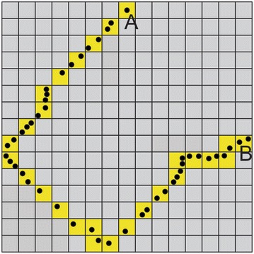
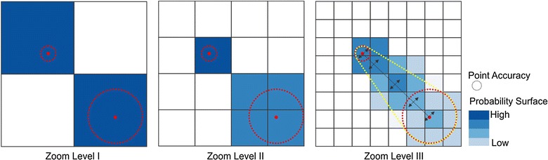
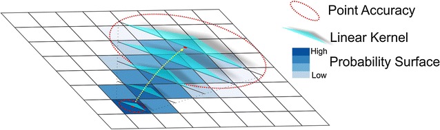
In this study, we propose and implement an innovative system that integrates smartphone-based step tracking with an app and the sequential tile scan techniques to collect and process activity data. We apply the OpenStreetMap tile system to aggregate positioning points at various scales. We also propose duration, step and probability surfaces to quantify the multi-dimensional attributes of activities.

RESULTS

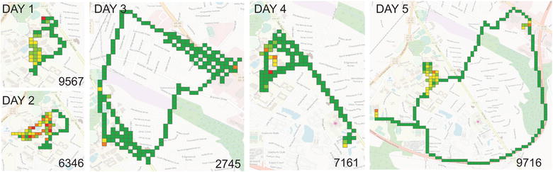
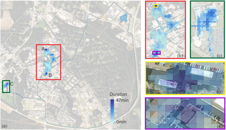
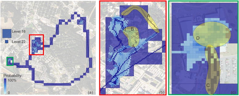
Results show that, by running the app in the background, smartphones can measure multi-dimensional attributes of human activities, including space, duration, step, and location uncertainty at various spatial scales. By coordinating Global Positioning System (GPS) sensor with accelerometer sensor, this app can save battery which otherwise would be drained by GPS sensor quickly. Based on a test dataset, we were able to detect the recreational center and sports center as the space where the user was most active, among other places visited.

CONCLUSION

The methods provide techniques to address key issues in analyzing human activity data. The system can support future studies on behavioral and health consequences related to individual's environmental exposure.

摘要

背景

在过去几十年中,位置感知技术和信息通信技术的进步进一步加深了我们对人类活动与建筑环境之间相互作用的了解。越来越多的研究收集了关于个体活动的数据,以更好地了解环境如何塑造人类行为。尽管人们对此越来越感兴趣,但在收集和处理个体活动数据方面仍存在一些挑战,例如,捕捉人们精确的环境背景和在多个空间尺度上分析数据。

方法

在本研究中,我们提出并实现了一种创新系统,该系统将基于智能手机的计步跟踪与应用程序和顺序瓦片扫描技术相结合,用于收集和处理活动数据。我们应用 OpenStreetMap 瓦片系统在不同尺度上聚合定位点。我们还提出了持续时间、步长和概率曲面来量化活动的多维属性。

结果

结果表明,通过在后台运行应用程序,智能手机可以测量人类活动的多维属性,包括不同空间尺度的空间、持续时间、步长和位置不确定性。通过协调全球定位系统 (GPS) 传感器和加速度计传感器,该应用程序可以节省 GPS 传感器快速消耗的电池电量。基于测试数据集,我们能够检测到用户最活跃的空间,如娱乐中心和体育中心,以及其他访问过的地方。

结论

该方法提供了分析人类活动数据的关键问题的技术。该系统可以支持未来与个体环境暴露相关的行为和健康后果的研究。

https://cdn.ncbi.nlm.nih.gov/pmc/blobs/fcd7/5941789/36ce33914502/12942_2018_130_Fig11_HTML.jpg
https://cdn.ncbi.nlm.nih.gov/pmc/blobs/fcd7/5941789/11b11ddbeba1/12942_2018_130_Fig1_HTML.jpg
https://cdn.ncbi.nlm.nih.gov/pmc/blobs/fcd7/5941789/09d61da73fc1/12942_2018_130_Fig2_HTML.jpg
https://cdn.ncbi.nlm.nih.gov/pmc/blobs/fcd7/5941789/80f6dd00dbf3/12942_2018_130_Fig3_HTML.jpg
https://cdn.ncbi.nlm.nih.gov/pmc/blobs/fcd7/5941789/70fe23e48ad5/12942_2018_130_Fig4_HTML.jpg
https://cdn.ncbi.nlm.nih.gov/pmc/blobs/fcd7/5941789/18b057f0f154/12942_2018_130_Fig5_HTML.jpg
https://cdn.ncbi.nlm.nih.gov/pmc/blobs/fcd7/5941789/09870e9abc8d/12942_2018_130_Fig6_HTML.jpg
https://cdn.ncbi.nlm.nih.gov/pmc/blobs/fcd7/5941789/ddb1c2a604fe/12942_2018_130_Fig7_HTML.jpg
https://cdn.ncbi.nlm.nih.gov/pmc/blobs/fcd7/5941789/eeb50a45b012/12942_2018_130_Fig8_HTML.jpg
https://cdn.ncbi.nlm.nih.gov/pmc/blobs/fcd7/5941789/010a022b6bb5/12942_2018_130_Fig9_HTML.jpg
https://cdn.ncbi.nlm.nih.gov/pmc/blobs/fcd7/5941789/d0bdf4e1ef38/12942_2018_130_Fig10_HTML.jpg
https://cdn.ncbi.nlm.nih.gov/pmc/blobs/fcd7/5941789/36ce33914502/12942_2018_130_Fig11_HTML.jpg

相似文献

1
Quantifying multi-dimensional attributes of human activities at various geographic scales based on smartphone tracking.基于智能手机追踪技术,量化不同地理尺度下人类活动的多维属性。
Int J Health Geogr. 2018 May 9;17(1):11. doi: 10.1186/s12942-018-0130-3.
2
User acceptance of location-tracking technologies in health research: Implications for study design and data quality.健康研究中位置追踪技术的用户接受度:对研究设计和数据质量的影响。
J Biomed Inform. 2018 Mar;79:7-19. doi: 10.1016/j.jbi.2018.01.003. Epub 2018 Jan 31.
3
Quantifying Human Movement Using the Movn Smartphone App: Validation and Field Study.使用Movn智能手机应用程序量化人体运动:验证与实地研究。
JMIR Mhealth Uhealth. 2017 Aug 17;5(8):e122. doi: 10.2196/mhealth.7167.
4
A Smartphone App Combining Global Positioning System Data and Ecological Momentary Assessment to Track Individual Food Environment Exposure, Food Purchases, and Food Consumption: Protocol for the Observational FoodTrack Study.一款结合全球定位系统数据与生态瞬时评估以追踪个体食物环境暴露、食物购买及食物消费情况的智能手机应用程序:观察性食物追踪研究方案
JMIR Res Protoc. 2020 Jan 28;9(1):e15283. doi: 10.2196/15283.
5
Assessing and enhancing the utility of low-cost activity and location sensors for exposure studies.评估和增强低成本活动和位置传感器在暴露研究中的效用。
Environ Monit Assess. 2018 Feb 20;190(3):155. doi: 10.1007/s10661-018-6537-2.
6
Concordance between GPS-based smartphone app for continuous location tracking and mother's recall of care-seeking for child illness in India.基于 GPS 的智能手机应用程序进行连续位置追踪与印度母亲回忆寻求儿童疾病治疗的一致性。
J Glob Health. 2018 Dec;8(2):020802. doi: 10.7189/jogh.08.020802.
7
Comparing Location Data From Smartphone and Dedicated Global Positioning System Devices: Implications for Epidemiologic Research.比较智能手机和专用全球定位系统设备中的位置数据:对流行病学研究的启示。
Am J Epidemiol. 2024 Jan 8;193(1):180-192. doi: 10.1093/aje/kwad176.
8
Intrinsic dimensionality of human behavioral activity data.人类行为活动数据的内在维度。
PLoS One. 2019 Jun 27;14(6):e0218966. doi: 10.1371/journal.pone.0218966. eCollection 2019.
9
A multi-sensor monitoring system of human physiology and daily activities.多传感器人体生理与日常活动监测系统。
Telemed J E Health. 2012 Apr;18(3):185-92. doi: 10.1089/tmj.2011.0138.
10
Perceptions of Smartphone User-Centered Mobile Health Tracking Apps Across Various Chronic Illness Populations: An Integrative Review.不同慢性病群体对以用户为中心的智能手机移动健康追踪应用程序的认知:一项综合综述。
J Nurs Scholarsh. 2017 Jul;49(4):371-378. doi: 10.1111/jnu.12298. Epub 2017 Jun 12.

引用本文的文献

1
An Alternative Athlete Monitoring System Using Cost-Effective Inertial Sensing Instrumentation.一种使用经济高效惯性传感仪器的替代运动员监测系统。
J Electr Eng Technol. 2022;17(6):3581-3592. doi: 10.1007/s42835-022-01258-1. Epub 2022 Sep 26.
2
Wireless muometric navigation system.无线肌动度量导航系统。
Sci Rep. 2022 Jun 16;12(1):10114. doi: 10.1038/s41598-022-13280-4.
3
Innovations in research and clinical care using patient-generated health data.利用患者生成的健康数据进行研究和临床护理的创新。

本文引用的文献

1
The association between park visitation and physical activity measured with accelerometer, GPS, and travel diary.使用加速度计、全球定位系统和旅行日记测量的公园游览与身体活动之间的关联。
Health Place. 2016 Mar;38:82-8. doi: 10.1016/j.healthplace.2016.01.004. Epub 2016 Feb 1.
2
Contextual Uncertainties, Human Mobility, and Perceived Food Environment: The Uncertain Geographic Context Problem in Food Access Research.情境不确定性、人口流动与感知食物环境:食物获取研究中的不确定地理情境问题
Am J Public Health. 2015 Sep;105(9):1734-7. doi: 10.2105/AJPH.2015.302792. Epub 2015 Jul 16.
3
Accuracy of smartphone applications and wearable devices for tracking physical activity data.
CA Cancer J Clin. 2020 May;70(3):182-199. doi: 10.3322/caac.21608. Epub 2020 Apr 20.
4
Activity space metrics not associated with sociodemographic variables, diet or health outcomes in the Seattle Obesity Study II.在西雅图肥胖研究II中,活动空间指标与社会人口统计学变量、饮食或健康结果无关。
Spat Spatiotemporal Epidemiol. 2019 Aug;30:100289. doi: 10.1016/j.sste.2019.100289. Epub 2019 Jul 12.
5
Dyamic Urban nvironmental xposures on epression and uicide (NEEDS) in the Netherlands: a protocol for a cross-sectional smartphone tracking study and a longitudinal population register study.荷兰动态城市环境暴露与抑郁和自杀(NEEDS)研究:一项基于智能手机的横断面追踪研究和一项纵向人群登记研究方案。
BMJ Open. 2019 Aug 10;9(8):e030075. doi: 10.1136/bmjopen-2019-030075.
6
Smartphone GPS accuracy study in an urban environment.智能手机 GPS 精度在城市环境中的研究。
PLoS One. 2019 Jul 18;14(7):e0219890. doi: 10.1371/journal.pone.0219890. eCollection 2019.
用于追踪身体活动数据的智能手机应用程序和可穿戴设备的准确性。
JAMA. 2015 Feb 10;313(6):625-6. doi: 10.1001/jama.2014.17841.
4
Disentangling neighborhood contextual associations with child body mass index, diet, and physical activity: the role of built, socioeconomic, and social environments.解析邻里环境与儿童体重指数、饮食和身体活动的关联:建筑环境、社会经济环境和社会环境的作用。
Soc Sci Med. 2013 Oct;95:106-14. doi: 10.1016/j.socscimed.2013.04.003. Epub 2013 Apr 10.
5
The local food environment and diet: a systematic review.本地食物环境与饮食:系统评价。
Health Place. 2012 Sep;18(5):1172-87. doi: 10.1016/j.healthplace.2012.05.006. Epub 2012 May 31.
6
Using global positioning systems in health research: a practical approach to data collection and processing.利用全球定位系统进行健康研究:数据收集和处理的实用方法。
Am J Prev Med. 2011 Nov;41(5):532-40. doi: 10.1016/j.amepre.2011.07.017.
7
Activity space environment and dietary and physical activity behaviors: a pilot study.活动空间环境与饮食和身体活动行为:一项初步研究。
Health Place. 2011 Sep;17(5):1150-61. doi: 10.1016/j.healthplace.2011.05.001. Epub 2011 May 17.
8
Relationships of land use mix with walking for transport: do land uses and geographical scale matter?土地利用混合度与交通步行的关系:土地利用类型和地理尺度是否重要?
J Urban Health. 2010 Sep;87(5):782-95. doi: 10.1007/s11524-010-9488-7.
9
What is the best dose of nature and green exercise for improving mental health? A multi-study analysis.什么样的自然和绿色运动剂量最有利于改善心理健康?一项多研究分析。
Environ Sci Technol. 2010 May 15;44(10):3947-55. doi: 10.1021/es903183r.
10
The built environment and location-based physical activity.建筑环境与基于位置的身体活动。
Am J Prev Med. 2010 Apr;38(4):429-38. doi: 10.1016/j.amepre.2009.12.032.