• 文献检索
  • 文档翻译
  • 深度研究
  • 学术资讯
  • Suppr Zotero 插件Zotero 插件
  • 邀请有礼
  • 套餐&价格
  • 历史记录
应用&插件
Suppr Zotero 插件Zotero 插件浏览器插件Mac 客户端Windows 客户端微信小程序
定价
高级版会员购买积分包购买API积分包
服务
文献检索文档翻译深度研究API 文档MCP 服务
关于我们
关于 Suppr公司介绍联系我们用户协议隐私条款
关注我们

Suppr 超能文献

核心技术专利:CN118964589B侵权必究
粤ICP备2023148730 号-1Suppr @ 2026

文献检索

告别复杂PubMed语法,用中文像聊天一样搜索,搜遍4000万医学文献。AI智能推荐,让科研检索更轻松。

立即免费搜索

文件翻译

保留排版,准确专业,支持PDF/Word/PPT等文件格式,支持 12+语言互译。

免费翻译文档

深度研究

AI帮你快速写综述,25分钟生成高质量综述,智能提取关键信息,辅助科研写作。

立即免费体验

哨兵-2A影像的多光谱配准偏差:分析及其对潜在应用的影响

Multi-spectral misregistration of Sentinel-2A images: analysis and implications for potential applications.

作者信息

Skakun Sergii, Vermote Eric, Roger Jean-Claude, Justice Christopher

机构信息

Department of Geographical Sciences, University of Maryland, College Park, MD 20742 USA.

Terrestrial Information Systems Laboratory (Code 619), NASA Goddard Space Flight Center, Greenbelt, MD 20771 USA.

出版信息

IEEE Geosci Remote Sens Lett. 2017 Dec;14(12):2408-2412. doi: 10.1109/LGRS.2017.2766448. Epub 2017 Nov 10.

DOI:10.1109/LGRS.2017.2766448
PMID:29893382
原文链接:https://pmc.ncbi.nlm.nih.gov/articles/PMC5992602/
Abstract

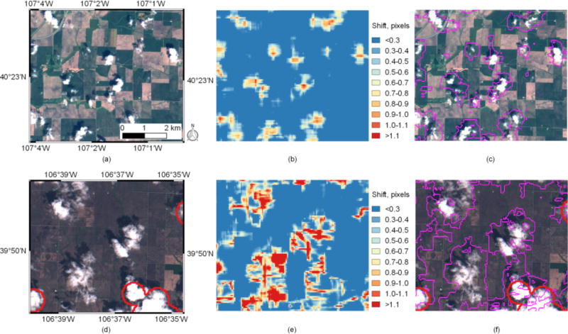
This study aims at analyzing sub-pixel misregistration between multi-spectral images acquired by the Multi-Spectral Instrument (MSI) aboard Sentinel-2A remote sensing satellite, and exploring its potential for moving target and cloud detection. By virtue of its hardware design, MSI's detectors exhibit a parallax angle that leads to sub-pixel shifts that are corrected with special pre-processing routines. However, these routines do not correct shifts for moving and/or high altitude objects. In this letter, we apply a phase correlation approach to detect sub-pixel shifts between B2 (blue), B3 (green) and B4 (red) Sentinel-2A/MSI images. We show that shifts of more than 1.1 pixels can be observed for moving targets, such as airplanes and clouds, and can be used for cloud detection. We demonstrate that the proposed approach can detect clouds that are not identified in the built-in cloud mask provided within the Sentinel-2A Level-1C (L1C) product.

摘要

本研究旨在分析哨兵 - 2A 遥感卫星搭载的多光谱仪器(MSI)获取的多光谱图像之间的亚像素配准误差,并探索其在移动目标和云检测方面的潜力。由于其硬件设计,MSI 的探测器存在视差角,会导致亚像素偏移,需通过特殊的预处理程序进行校正。然而,这些程序无法校正移动和/或高空物体的偏移。在本信函中,我们应用相位相关方法来检测哨兵 - 2A/MSI 的 B2(蓝色)、B3(绿色)和 B4(红色)图像之间的亚像素偏移。我们发现,对于飞机和云等移动目标,可观察到超过 1.1 像素的偏移,且可用于云检测。我们证明,所提出的方法能够检测出哨兵 - 2A 一级 C 级(L1C)产品中内置云掩码未识别出的云。

https://cdn.ncbi.nlm.nih.gov/pmc/blobs/e4e4/5992602/d0c7cee3ce32/nihms931297f4.jpg
https://cdn.ncbi.nlm.nih.gov/pmc/blobs/e4e4/5992602/6c2a21931797/nihms931297f1.jpg
https://cdn.ncbi.nlm.nih.gov/pmc/blobs/e4e4/5992602/3ad9123460fd/nihms931297f2.jpg
https://cdn.ncbi.nlm.nih.gov/pmc/blobs/e4e4/5992602/3798150e6f2d/nihms931297f3.jpg
https://cdn.ncbi.nlm.nih.gov/pmc/blobs/e4e4/5992602/d0c7cee3ce32/nihms931297f4.jpg

相似文献

1
Multi-spectral misregistration of Sentinel-2A images: analysis and implications for potential applications.哨兵-2A影像的多光谱配准偏差:分析及其对潜在应用的影响
IEEE Geosci Remote Sens Lett. 2017 Dec;14(12):2408-2412. doi: 10.1109/LGRS.2017.2766448. Epub 2017 Nov 10.
2
Automatic sub-pixel co-registration of Landsat-8 OLI and Sentinel-2A MSI images using phase correlation and machine learning based mapping.基于相位相关和机器学习映射的陆地卫星8号OLI和哨兵2A号MSI图像自动亚像素配准
Int J Digit Earth. 2017 Mar 23;Volume 10(Iss 12):1253-1269. doi: 10.1080/17538947.2017.1304586.
3
Remote detection of marine debris using Sentinel-2 imagery: A cautious note on spectral interpretations.利用 Sentinel-2 图像进行海洋垃圾的远程探测:光谱解释需谨慎。
Mar Pollut Bull. 2022 Oct;183:114082. doi: 10.1016/j.marpolbul.2022.114082. Epub 2022 Sep 5.
4
A hybrid generative adversarial network for weakly-supervised cloud detection in multispectral images.一种用于多光谱图像中弱监督云检测的混合生成对抗网络。
Remote Sens Environ. 2022 Oct;280:113197. doi: 10.1016/j.rse.2022.113197.
5
CloudSEN12, a global dataset for semantic understanding of cloud and cloud shadow in Sentinel-2.CloudSEN12,一个用于理解 Sentinel-2 中云和云影语义的全球数据集。
Sci Data. 2022 Dec 24;9(1):782. doi: 10.1038/s41597-022-01878-2.
6
Pan-tropical Sentinel-2 cloud-free annual composite datasets.泛热带哨兵2号无云年度合成数据集。
Data Brief. 2021 Oct 18;39:107488. doi: 10.1016/j.dib.2021.107488. eCollection 2021 Dec.
7
Remote sensing of CDOM and DOC in alpine lakes across the Qinghai-Tibet Plateau using Sentinel-2A imagery data.利用 Sentinel-2A 图像数据对青藏高原高寒湖泊的 CDOM 和 DOC 进行遥感研究。
J Environ Manage. 2021 May 15;286:112231. doi: 10.1016/j.jenvman.2021.112231. Epub 2021 Mar 8.
8
Understanding the temporal dimension of the red-edge spectral region for forest decline detection using high-resolution hyperspectral and Sentinel-2a imagery.利用高分辨率高光谱和哨兵 - 2a 影像理解用于森林衰退检测的红边光谱区域的时间维度。
ISPRS J Photogramm Remote Sens. 2018 Mar;137:134-148. doi: 10.1016/j.isprsjprs.2018.01.017.
9
Object-based characterization of vegetation heterogeneity with sentinel images proves efficient in a highly human-influenced National Park of Côte d'Ivoire.利用哨兵图像对植被异质性进行基于对象的特征描述在受人类高度影响的科特迪瓦国家公园中非常有效。
Environ Monit Assess. 2022 Dec 15;195(1):200. doi: 10.1007/s10661-022-10792-4.
10
Extraction of High-Precision Urban Impervious Surfaces from Sentinel-2 Multispectral Imagery via Modified Linear Spectral Mixture Analysis.基于改进线性光谱混合分析的 Sentinel-2 多光谱影像高精度城市不透水面提取。
Sensors (Basel). 2018 Aug 31;18(9):2873. doi: 10.3390/s18092873.

引用本文的文献

1
Intercomparison of Same-Day Remote Sensing Data for Measuring Winter Cover Crop Biophysical Traits.同日遥感数据在冬季覆盖作物生物物理特性测量中的对比分析。
Sensors (Basel). 2024 Apr 6;24(7):2339. doi: 10.3390/s24072339.
2
Aircraft and Ship Velocity Determination in Sentinel-2 Multispectral Images.哨兵 - 2 多光谱图像中飞机和船舶速度的测定
Sensors (Basel). 2019 Jun 28;19(13):2873. doi: 10.3390/s19132873.
3
A Novel Approach for Mapping Wheat Areas Using High Resolution Sentinel-2 Images.利用高分辨率哨兵 2 图像绘制小麦种植区的新方法。

本文引用的文献

1
Automatic sub-pixel co-registration of Landsat-8 OLI and Sentinel-2A MSI images using phase correlation and machine learning based mapping.基于相位相关和机器学习映射的陆地卫星8号OLI和哨兵2A号MSI图像自动亚像素配准
Int J Digit Earth. 2017 Mar 23;Volume 10(Iss 12):1253-1269. doi: 10.1080/17538947.2017.1304586.
2
Preliminary analysis of the performance of the Landsat 8/OLI land surface reflectance product.陆地卫星8号/OLI地表反射率产品性能的初步分析
Remote Sens Environ. 2016 Apr 28;Volume 185(Iss 2):46-56. doi: 10.1016/j.rse.2016.04.008.
3
Extension of phase correlation to subpixel registration.
Sensors (Basel). 2018 Jun 29;18(7):2089. doi: 10.3390/s18072089.
将相位相关扩展到亚像素配准。
IEEE Trans Image Process. 2002;11(3):188-200. doi: 10.1109/83.988953.
4
Efficient subpixel image registration algorithms.高效亚像素图像配准算法。
Opt Lett. 2008 Jan 15;33(2):156-8. doi: 10.1364/ol.33.000156.