• 文献检索
  • 文档翻译
  • 深度研究
  • 学术资讯
  • Suppr Zotero 插件Zotero 插件
  • 邀请有礼
  • 套餐&价格
  • 历史记录
应用&插件
Suppr Zotero 插件Zotero 插件浏览器插件Mac 客户端Windows 客户端微信小程序
定价
高级版会员购买积分包购买API积分包
服务
文献检索文档翻译深度研究API 文档MCP 服务
关于我们
关于 Suppr公司介绍联系我们用户协议隐私条款
关注我们

Suppr 超能文献

核心技术专利:CN118964589B侵权必究
粤ICP备2023148730 号-1Suppr @ 2026

文献检索

告别复杂PubMed语法,用中文像聊天一样搜索,搜遍4000万医学文献。AI智能推荐,让科研检索更轻松。

立即免费搜索

文件翻译

保留排版,准确专业,支持PDF/Word/PPT等文件格式,支持 12+语言互译。

免费翻译文档

深度研究

AI帮你快速写综述,25分钟生成高质量综述,智能提取关键信息,辅助科研写作。

立即免费体验

不同空间尺度的洪水风险评估。

Flood risk assessments at different spatial scales.

作者信息

de Moel H, Jongman B, Kreibich H, Merz B, Penning-Rowsell E, Ward P J

机构信息

Institute for Environmental Studies, VU University, Amsterdam, Netherlands.

GFZ German Research Centre for Geosciences, Helmholtz Centre Potsdam, Potsdam, Germany.

出版信息

Mitig Adapt Strateg Glob Chang. 2015;20(6):865-890. doi: 10.1007/s11027-015-9654-z. Epub 2015 May 22.

DOI:10.1007/s11027-015-9654-z
PMID:30197555
原文链接:https://pmc.ncbi.nlm.nih.gov/articles/PMC6108001/
Abstract

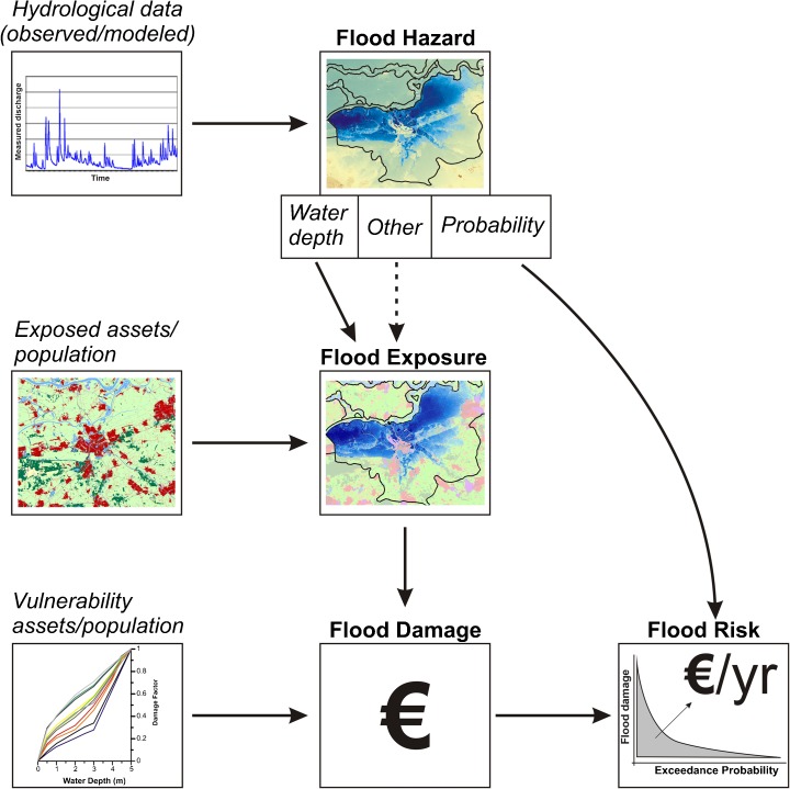
Managing flood risk, i.e. both the hazard and the potential consequences, is an important aspect of adapting to global change and has gained much traction in recent decades. As a result, a priori flood risk assessments have become an important part of flood management practices. Many methodologies have been set up, ranging from global risk assessments for the world as a whole, to local assessments for a particular stretch of a river/coast or small town. Most assessment frameworks generally follow a similar approach, but there are also notable differences between assessments at different spatial scales. This review article examines these differences, for instance those related to the methodology, use of assessments and uncertainties. From this review, future research needs are identified in order to improve flood risk assessments at different scales. At global/continental scale, there is a clear need for harmonised information on flood defences to improve assessments. Furthermore, inclusions of indirect economic effects at the macro-/meso-scale would give a better indication of the total effects of catastrophic flooding. At the meso-/micro-scale, there is an urgent need to improve our understanding of the effects of flooding on critical infrastructures, given their importance to society, the economy, emergency management and reconstruction. An overarching theme at all scales is the validation of flood risk assessments, which is often limited. More detailed post-disaster information would allow for improved calibration, validation and thus performance of flood risk models. Lastly, the link between spatial scales also deserves attention, for instance up- or downscaling methodologies.

摘要

管理洪水风险,即洪水灾害及其潜在后果,是适应全球变化的一个重要方面,并且在近几十年中受到了广泛关注。因此,先验洪水风险评估已成为洪水管理实践的重要组成部分。已经建立了许多方法,从针对全球的全球风险评估到针对特定河段/海岸或小镇的局部评估。大多数评估框架通常遵循类似的方法,但不同空间尺度的评估之间也存在显著差异。这篇综述文章研究了这些差异,例如与方法、评估用途和不确定性相关的差异。通过这篇综述,确定了未来的研究需求,以改进不同尺度的洪水风险评估。在全球/大陆尺度上,显然需要关于防洪的统一信息来改进评估。此外,在宏观/中观尺度纳入间接经济影响将能更好地表明灾难性洪水的总体影响。在中观/微观尺度上,鉴于关键基础设施对社会、经济、应急管理和重建的重要性,迫切需要提高我们对洪水对其影响的理解。所有尺度的一个总体主题是洪水风险评估的验证,而这往往是有限的。更详细的灾后信息将有助于改进洪水风险模型的校准、验证以及性能。最后,空间尺度之间的联系也值得关注,例如向上或向下缩放方法。

https://cdn.ncbi.nlm.nih.gov/pmc/blobs/15ed/6108001/868052765406/11027_2015_9654_Fig1_HTML.jpg

相似文献

1
Flood risk assessments at different spatial scales.不同空间尺度的洪水风险评估。
Mitig Adapt Strateg Glob Chang. 2015;20(6):865-890. doi: 10.1007/s11027-015-9654-z. Epub 2015 May 22.
2
Coastal and river flood risk analyses for guiding economically optimal flood adaptation policies: a country-scale study for Mexico.用于指导经济上最优的洪水适应政策的沿海和河流洪水风险分析:墨西哥的国家尺度研究
Philos Trans A Math Phys Eng Sci. 2018 Jun 13;376(2121). doi: 10.1098/rsta.2017.0329.
3
Flood vulnerability indices at varying spatial scales.不同空间尺度的洪水脆弱性指数。
Water Sci Technol. 2009;60(10):2571-80. doi: 10.2166/wst.2009.183.
4
Coastal flood risks in China through the 21st century - An application of DIVA.中国沿海地区 21 世纪的洪水风险——DIVA 的应用。
Sci Total Environ. 2020 Feb 20;704:135311. doi: 10.1016/j.scitotenv.2019.135311. Epub 2019 Nov 20.
5
Assessment of Supply and Demand of Regional Flood Regulation Ecosystem Services and Zoning Management in Response to Flood Disasters: A Case Study of Fujian Delta.评估区域洪调生态系统服务的供需情况及洪灾响应的分区管理——以福建三角洲为例
Int J Environ Res Public Health. 2022 Dec 29;20(1):589. doi: 10.3390/ijerph20010589.
6
Biases in national and continental flood risk assessments by ignoring spatial dependence.忽略空间相关性导致国家和大陆洪水风险评估存在偏差。
Sci Rep. 2020 Nov 9;10(1):19387. doi: 10.1038/s41598-020-76523-2.
7
A systematic review of the flood vulnerability using geographic information system.使用地理信息系统对洪水脆弱性进行的系统综述。
Heliyon. 2022 Mar 8;8(3):e09075. doi: 10.1016/j.heliyon.2022.e09075. eCollection 2022 Mar.
8
Adapting to Climate Change in the Upper Mississippi River Basin: Exploring Stakeholder Perspectives on River System Management and Flood Risk Reduction.适应密西西比河上游流域的气候变化:探索利益相关者对河流系统管理和降低洪水风险的看法。
Environ Health Insights. 2020 Dec 28;14:1178630220984153. doi: 10.1177/1178630220984153. eCollection 2020.
9
A spatial framework to explore needs and opportunities for interoperable urban flood management.探索可互操作的城市洪水管理的需求和机会的空间框架。
Philos Trans A Math Phys Eng Sci. 2020 Apr 3;378(2168):20190205. doi: 10.1098/rsta.2019.0205. Epub 2020 Feb 17.
10
Community's Emergency Preparedness for Flood Hazards in Dire-dawa Town, Ethiopia: A Qualitative Study.埃塞俄比亚德雷达瓦镇社区对洪水灾害的应急准备:一项定性研究。
PLoS Curr. 2018 Feb 21;10:ecurrents.dis.3843ad9fc823c8c853970148b350750c. doi: 10.1371/currents.dis.3843ad9fc823c8c853970148b350750c.

引用本文的文献

1
Local acceleration of coastal flood risk in response to relative sea level change.沿海洪水风险因相对海平面变化而产生的局部加速。
Sci Rep. 2025 Jul 26;15(1):27241. doi: 10.1038/s41598-025-13021-3.
2
Monitoring flood risk evolution: A systematic review.监测洪水风险演变:一项系统综述。
iScience. 2024 Aug 23;27(9):110653. doi: 10.1016/j.isci.2024.110653. eCollection 2024 Sep 20.
3
A satellite imagery-driven framework for rapid resource allocation in flood scenarios to enhance loss and damage fund effectiveness.一个由卫星图像驱动的框架,用于在洪水场景中快速分配资源,以提高损失和损害基金的有效性。

本文引用的文献

1
Adaptive flood risk management planning based on a comprehensive flood risk conceptualisation.基于全面洪水风险概念化的适应性洪水风险管理规划。
Mitig Adapt Strateg Glob Chang. 2015;20(6):845-864. doi: 10.1007/s11027-015-9638-z. Epub 2015 Mar 12.
2
Integrated Direct and Indirect Flood Risk Modeling: Development and Sensitivity Analysis.综合直接和间接洪水风险建模:开发与敏感性分析
Risk Anal. 2015 May;35(5):882-900. doi: 10.1111/risa.12300. Epub 2014 Dec 16.
3
Strong influence of El Niño Southern Oscillation on flood risk around the world.
Sci Rep. 2024 Aug 20;14(1):19290. doi: 10.1038/s41598-024-69977-1.
4
Citizen scientists' engagement in flood risk-related data collection: a case study in Bui River Basin, Vietnam.公民科学家参与洪水风险相关数据收集:以越南布伊河流域为例。
Environ Monit Assess. 2024 Feb 17;196(3):280. doi: 10.1007/s10661-024-12419-2.
5
Exploring spatial feedbacks between adaptation policies and internal migration patterns due to sea-level rise.探讨海平面上升导致的适应政策与国内人口迁移模式之间的空间反馈。
Nat Commun. 2023 May 6;14(1):2630. doi: 10.1038/s41467-023-38278-y.
6
A coupled agent-based model for France for simulating adaptation and migration decisions under future coastal flood risk.基于代理的耦合模型在法国的应用:模拟未来沿海洪水风险下的适应和迁移决策。
Sci Rep. 2023 Mar 13;13(1):4176. doi: 10.1038/s41598-023-31351-y.
7
A review of the flood management: from flood control to flood resilience.洪水管理综述:从防洪到洪水韧性
Heliyon. 2022 Nov 25;8(11):e11763. doi: 10.1016/j.heliyon.2022.e11763. eCollection 2022 Nov.
8
Uncertainty and Bias in Global to Regional Scale Assessments of Current and Future Coastal Flood Risk.全球至区域尺度当前及未来沿海洪水风险评估中的不确定性与偏差
Earths Future. 2021 Jul;9(7):e2020EF001882. doi: 10.1029/2020EF001882. Epub 2021 Jul 20.
9
Learned Helplessness, Psychological Wellbeing, and Proenvironment Care Behavior among Victims of Frequent Floods in Kerala.喀拉拉邦频繁洪灾受害者的习得性无助、心理健康与亲环境关怀行为
J Neurosci Rural Pract. 2021 Jan;12(1):137-144. doi: 10.1055/s-0040-1721566. Epub 2021 Jan 29.
10
Assessing the effects of using high-quality data and high-resolution models in valuing flood protection services of mangroves.评估在评估红树林防洪服务价值时使用高质量数据和高分辨率模型的效果。
PLoS One. 2019 Aug 20;14(8):e0220941. doi: 10.1371/journal.pone.0220941. eCollection 2019.
厄尔尼诺-南方涛动对全球洪水风险有强烈影响。
Proc Natl Acad Sci U S A. 2014 Nov 4;111(44):15659-64. doi: 10.1073/pnas.1409822111. Epub 2014 Oct 20.
4
Climate adaptation. Evaluating flood resilience strategies for coastal megacities.气候适应。评估沿海特大城市的洪水抵御策略。
Science. 2014 May 2;344(6183):473-5. doi: 10.1126/science.1248222.
5
Uncertainty and sensitivity of flood risk calculations for a dike ring in the south of the Netherlands.荷兰南部堤防圈洪水风险计算的不确定性和敏感性。
Sci Total Environ. 2014 Mar 1;473-474:224-34. doi: 10.1016/j.scitotenv.2013.12.015. Epub 2013 Dec 25.
6
Cost estimates for flood resilience and protection strategies in New York City.纽约市洪水韧性和保护策略的成本估算。
Ann N Y Acad Sci. 2013 Aug;1294:1-104. doi: 10.1111/nyas.12200.
7
Modeling imbalanced economic recovery following a natural disaster using input-output analysis.运用投入产出分析模型来模拟自然灾害后的经济复苏失衡状况。
Risk Anal. 2013 Oct;33(10):1908-23. doi: 10.1111/risa.12040. Epub 2013 Apr 24.
8
Low-probability flood risk modeling for New York City.纽约市低概率洪水风险建模。
Risk Anal. 2013 May;33(5):772-88. doi: 10.1111/risa.12008. Epub 2013 Feb 5.
9
Disaster management. Redesigning flood insurance.灾害管理。重新设计洪水保险。
Science. 2011 Jul 22;333(6041):408-9. doi: 10.1126/science.1202616.
10
Uncertainty in urban flood damage assessment due to urban drainage modelling and depth-damage curve estimation.城市排水模型和水深-损害曲线估计导致城市洪水灾害评估中的不确定性。
Water Sci Technol. 2010;61(12):2979-93. doi: 10.2166/wst.2010.177.