• 文献检索
  • 文档翻译
  • 深度研究
  • 学术资讯
  • Suppr Zotero 插件Zotero 插件
  • 邀请有礼
  • 套餐&价格
  • 历史记录
应用&插件
Suppr Zotero 插件Zotero 插件浏览器插件Mac 客户端Windows 客户端微信小程序
定价
高级版会员购买积分包购买API积分包
服务
文献检索文档翻译深度研究API 文档MCP 服务
关于我们
关于 Suppr公司介绍联系我们用户协议隐私条款
关注我们

Suppr 超能文献

核心技术专利:CN118964589B侵权必究
粤ICP备2023148730 号-1Suppr @ 2026

文献检索

告别复杂PubMed语法,用中文像聊天一样搜索,搜遍4000万医学文献。AI智能推荐,让科研检索更轻松。

立即免费搜索

文件翻译

保留排版,准确专业,支持PDF/Word/PPT等文件格式,支持 12+语言互译。

免费翻译文档

深度研究

AI帮你快速写综述,25分钟生成高质量综述,智能提取关键信息,辅助科研写作。

立即免费体验

直接深度 SLAM:用于低纹理环境的稀疏几何特征增强的直接深度 SLAM 系统。

Direct Depth SLAM: Sparse Geometric Feature Enhanced Direct Depth SLAM System for Low-Texture Environments.

机构信息

Faculty of Robot Science and Engineering, Northeastern University, Shenyang 110819, China.

出版信息

Sensors (Basel). 2018 Oct 6;18(10):3339. doi: 10.3390/s18103339.

DOI:10.3390/s18103339
PMID:30301199
原文链接:https://pmc.ncbi.nlm.nih.gov/articles/PMC6210715/
Abstract

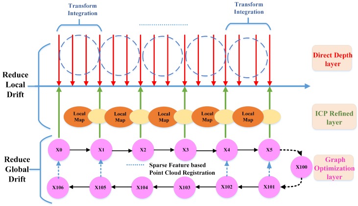
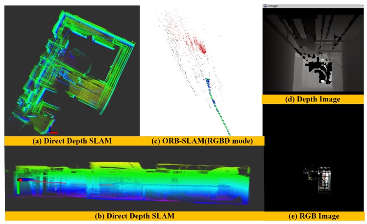
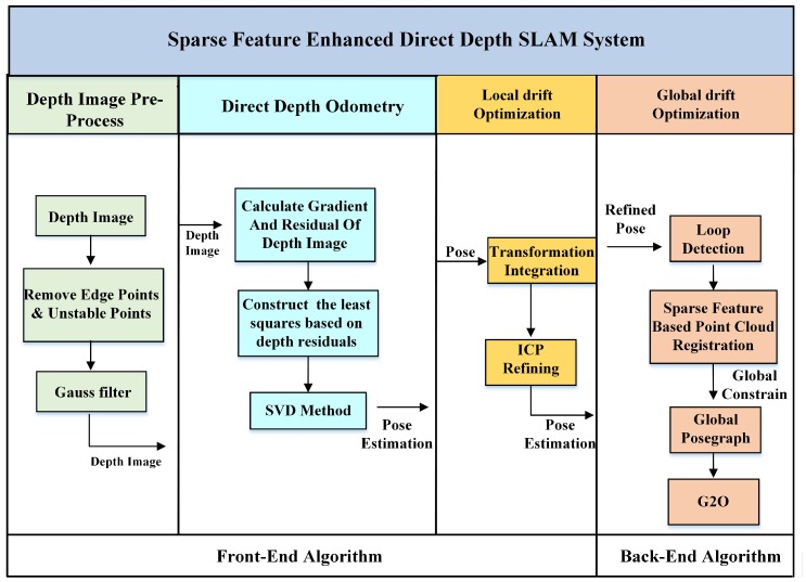
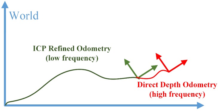
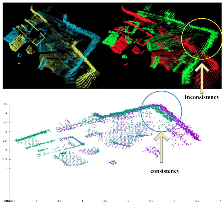
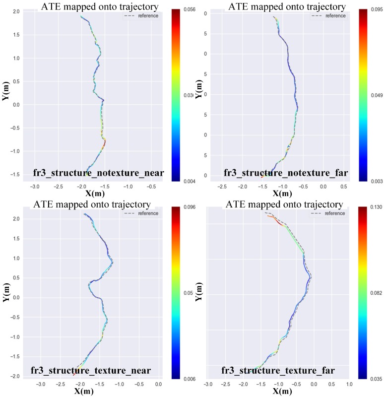
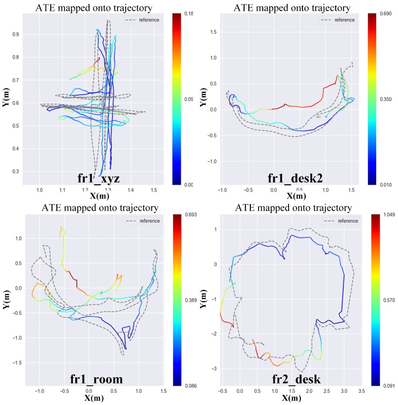
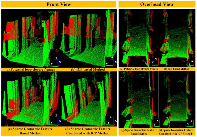
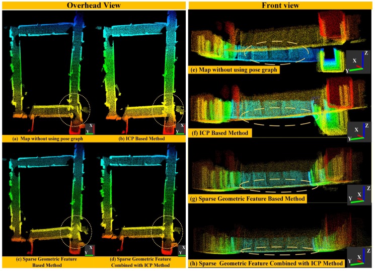
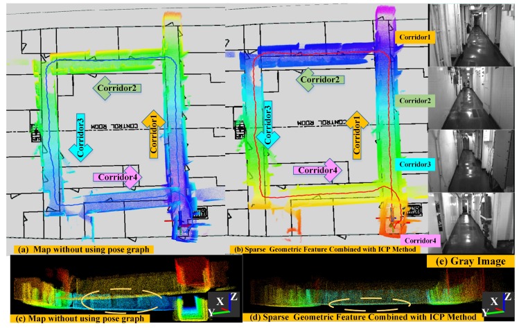
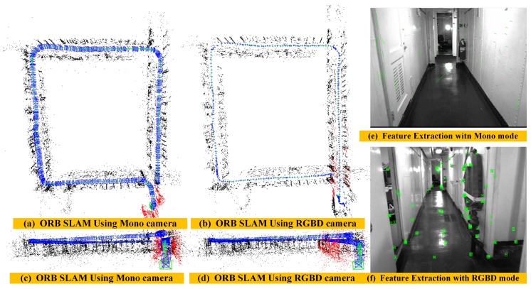
This paper presents a real-time, robust and low-drift depth-only SLAM (simultaneous localization and mapping) method for depth cameras by utilizing both dense range flow and sparse geometry features from sequential depth images. The proposed method is mainly composed of three optimization layers, namely Direct Depth layer, ICP (iterative closet point) Refined layer and Graph Optimization layer. The Direct Depth layer uses a range flow constraint equation to solve the fast 6-DOF (six degrees of freedom) frame-to-frame pose estimation problem. Then, the ICP Refined layer is used to reduce the local drift by applying local map based motion estimation strategy. After that, we propose a loop closure detection algorithm by extracting and matching sparse geometric features and construct a pose graph for the purpose of global pose optimization. We evaluate the performance of our method using benchmark datasets and real scene data. Experiment results show that our front-end algorithm clearly over performs the classic methods and our back-end algorithm is robust to find loop closures and reduce the global drift.

摘要

本文提出了一种实时、鲁棒且漂移小的基于深度相机的仅深度 SLAM(同时定位与建图)方法,该方法利用连续深度图像中的密集距离流和稀疏几何特征。所提出的方法主要由三个优化层组成,即直接深度层、ICP(迭代最近点)细化层和图优化层。直接深度层使用距离流约束方程来解决快速 6-DOF(六自由度)帧间姿态估计问题。然后,ICP 细化层通过应用基于局部地图的运动估计策略来减小局部漂移。之后,我们提出了一种通过提取和匹配稀疏几何特征来进行闭环检测的算法,并构建了一个姿态图,以进行全局姿态优化。我们使用基准数据集和真实场景数据来评估我们方法的性能。实验结果表明,我们的前端算法明显优于经典方法,而我们的后端算法能够稳健地找到闭环并减小全局漂移。

https://cdn.ncbi.nlm.nih.gov/pmc/blobs/8eeb/6210715/ec02a4fed79b/sensors-18-03339-g013.jpg
https://cdn.ncbi.nlm.nih.gov/pmc/blobs/8eeb/6210715/b2dc4be472bf/sensors-18-03339-g001.jpg
https://cdn.ncbi.nlm.nih.gov/pmc/blobs/8eeb/6210715/3b7a41483dda/sensors-18-03339-g002.jpg
https://cdn.ncbi.nlm.nih.gov/pmc/blobs/8eeb/6210715/afa708cd726b/sensors-18-03339-g003.jpg
https://cdn.ncbi.nlm.nih.gov/pmc/blobs/8eeb/6210715/3d37b7f3cd8f/sensors-18-03339-g004.jpg
https://cdn.ncbi.nlm.nih.gov/pmc/blobs/8eeb/6210715/12fa7bfb0634/sensors-18-03339-g005.jpg
https://cdn.ncbi.nlm.nih.gov/pmc/blobs/8eeb/6210715/285fffa4f0b0/sensors-18-03339-g006.jpg
https://cdn.ncbi.nlm.nih.gov/pmc/blobs/8eeb/6210715/3089ea225a81/sensors-18-03339-g007.jpg
https://cdn.ncbi.nlm.nih.gov/pmc/blobs/8eeb/6210715/0cac5d57399d/sensors-18-03339-g008.jpg
https://cdn.ncbi.nlm.nih.gov/pmc/blobs/8eeb/6210715/6be80b8ce1cd/sensors-18-03339-g009.jpg
https://cdn.ncbi.nlm.nih.gov/pmc/blobs/8eeb/6210715/855f3ee2a9be/sensors-18-03339-g010.jpg
https://cdn.ncbi.nlm.nih.gov/pmc/blobs/8eeb/6210715/f923f3493b31/sensors-18-03339-g011.jpg
https://cdn.ncbi.nlm.nih.gov/pmc/blobs/8eeb/6210715/bc0d7297ea57/sensors-18-03339-g012.jpg
https://cdn.ncbi.nlm.nih.gov/pmc/blobs/8eeb/6210715/ec02a4fed79b/sensors-18-03339-g013.jpg

相似文献

1
Direct Depth SLAM: Sparse Geometric Feature Enhanced Direct Depth SLAM System for Low-Texture Environments.直接深度 SLAM:用于低纹理环境的稀疏几何特征增强的直接深度 SLAM 系统。
Sensors (Basel). 2018 Oct 6;18(10):3339. doi: 10.3390/s18103339.
2
Incremental Pose Map Optimization for Monocular Vision SLAM Based on Similarity Transformation.基于相似变换的单目视觉 SLAM 增量位姿图优化。
Sensors (Basel). 2019 Nov 13;19(22):4945. doi: 10.3390/s19224945.
3
DiT-SLAM: Real-Time Dense Visual-Inertial SLAM with Implicit Depth Representation and Tightly-Coupled Graph Optimization.DiT-SLAM:基于隐式深度表示和紧密耦合图优化的实时密集视觉惯性同步定位与地图构建
Sensors (Basel). 2022 Apr 28;22(9):3389. doi: 10.3390/s22093389.
4
Real-Time Lidar Odometry and Mapping with Loop Closure.实时激光雷达里程计与回环检测。
Sensors (Basel). 2022 Jun 9;22(12):4373. doi: 10.3390/s22124373.
5
DOT-SLAM: A Stereo Visual Simultaneous Localization and Mapping (SLAM) System with Dynamic Object Tracking Based on Graph Optimization.DOT-SLAM:一种基于图优化的具有动态目标跟踪功能的立体视觉同步定位与地图构建(SLAM)系统。
Sensors (Basel). 2024 Jul 18;24(14):4676. doi: 10.3390/s24144676.
6
2D LiDAR SLAM Back-End Optimization with Control Network Constraint for Mobile Mapping.二维激光雷达 SLAM 后端优化与移动测绘的控制网络约束
Sensors (Basel). 2018 Oct 29;18(11):3668. doi: 10.3390/s18113668.
7
RC-SLAM: Road Constrained Stereo Visual SLAM System Based on Graph Optimization.RC-SLAM:基于图优化的道路约束立体视觉同步定位与地图构建系统
Sensors (Basel). 2024 Jan 15;24(2):0. doi: 10.3390/s24020536.
8
Fast and Robust Monocular Visua-Inertial Odometry Using Points and Lines.基于点和线的快速鲁棒单目视觉惯性里程计
Sensors (Basel). 2019 Oct 19;19(20):4545. doi: 10.3390/s19204545.
9
RGB-D SLAM Using Point-Plane Constraints for Indoor Environments.用于室内环境的基于点平面约束的RGB-D同步定位与地图构建
Sensors (Basel). 2019 Jun 17;19(12):2721. doi: 10.3390/s19122721.
10
SLAM Back-End Optimization Algorithm Based on Vision Fusion IPS.基于视觉融合 IPS 的 SLAM 后端优化算法。
Sensors (Basel). 2022 Dec 1;22(23):9362. doi: 10.3390/s22239362.

引用本文的文献

1
Perception in the Dark-Development of a ToF Visual Inertial Odometry System.黑暗中的感知——一种飞行时间视觉惯性里程计系统的开发
Sensors (Basel). 2020 Feb 26;20(5):1263. doi: 10.3390/s20051263.
2
Intensity-Assisted ICP for Fast Registration of 2D-LIDAR.用于二维激光雷达快速配准的强度辅助迭代最近点算法
Sensors (Basel). 2019 May 8;19(9):2124. doi: 10.3390/s19092124.
3
High Level 3D Structure Extraction from a Single Image Using a CNN-Based Approach.基于卷积神经网络的单幅图像高层三维结构提取。

本文引用的文献

1
Direct Sparse Odometry.直接稀疏里程计。
IEEE Trans Pattern Anal Mach Intell. 2018 Mar;40(3):611-625. doi: 10.1109/TPAMI.2017.2658577. Epub 2017 Apr 12.
2
MonoSLAM: real-time single camera SLAM.单目即时定位与地图构建(MonoSLAM):实时单目相机即时定位与地图构建
IEEE Trans Pattern Anal Mach Intell. 2007 Jun;29(6):1052-67. doi: 10.1109/TPAMI.2007.1049.
Sensors (Basel). 2019 Jan 29;19(3):563. doi: 10.3390/s19030563.