• 文献检索
  • 文档翻译
  • 深度研究
  • 学术资讯
  • Suppr Zotero 插件Zotero 插件
  • 邀请有礼
  • 套餐&价格
  • 历史记录
应用&插件
Suppr Zotero 插件Zotero 插件浏览器插件Mac 客户端Windows 客户端微信小程序
定价
高级版会员购买积分包购买API积分包
服务
文献检索文档翻译深度研究API 文档MCP 服务
关于我们
关于 Suppr公司介绍联系我们用户协议隐私条款
关注我们

Suppr 超能文献

核心技术专利:CN118964589B侵权必究
粤ICP备2023148730 号-1Suppr @ 2026

文献检索

告别复杂PubMed语法,用中文像聊天一样搜索,搜遍4000万医学文献。AI智能推荐,让科研检索更轻松。

立即免费搜索

文件翻译

保留排版,准确专业,支持PDF/Word/PPT等文件格式,支持 12+语言互译。

免费翻译文档

深度研究

AI帮你快速写综述,25分钟生成高质量综述,智能提取关键信息,辅助科研写作。

立即免费体验

CHRS 数据门户,一个易于访问的 PERSIANN 全球卫星降水数据公共存储库。

The CHRS Data Portal, an easily accessible public repository for PERSIANN global satellite precipitation data.

机构信息

Center for Hydrometeorology & Remote Sensing (CHRS), HSSoE, University of California, Irvine, CA, USA.

Department of Water Management, Nong Lam University, Ho Chi Minh City, Vietnam.

出版信息

Sci Data. 2019 Jan 8;6:180296. doi: 10.1038/sdata.2018.296.

DOI:10.1038/sdata.2018.296
PMID:30620343
原文链接:https://pmc.ncbi.nlm.nih.gov/articles/PMC6326112/
Abstract

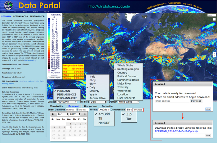
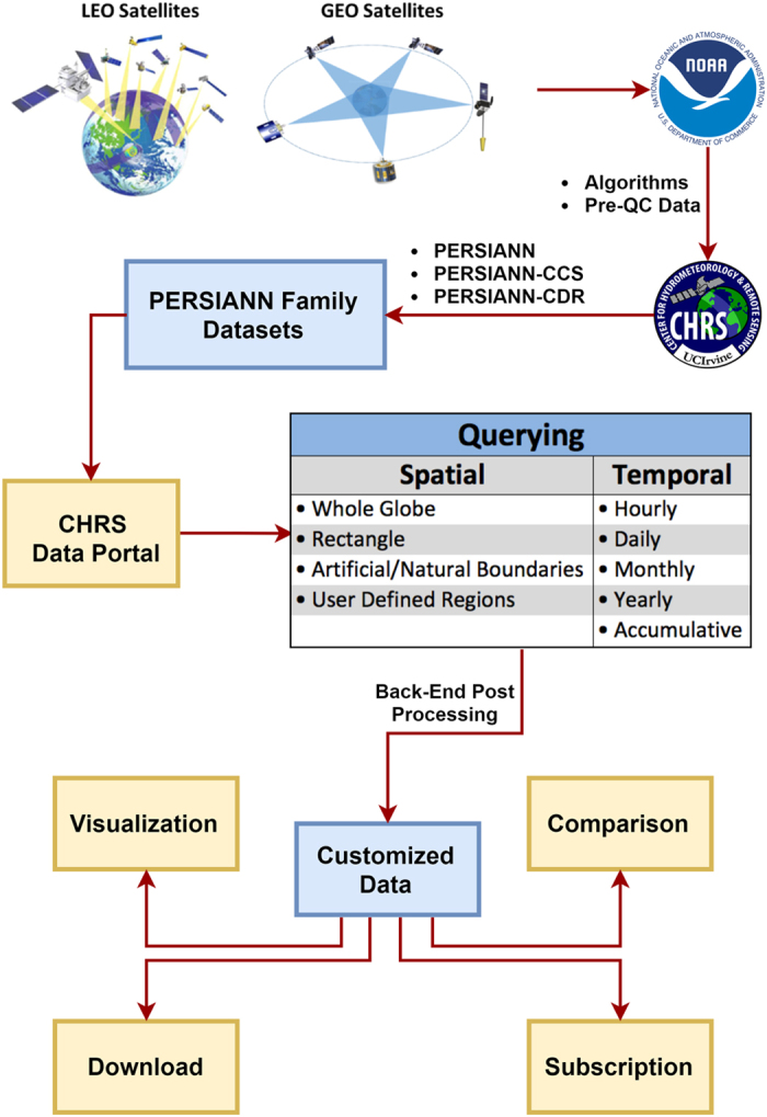
The Center for Hydrometeorology and Remote Sensing (CHRS) has created the CHRS Data Portal to facilitate easy access to the three open data licensed satellite-based precipitation datasets generated by our Precipitation Estimation from Remotely Sensed Information using Artificial Neural Networks (PERSIANN) system: PERSIANN, PERSIANN-Cloud Classification System (CCS), and PERSIANN-Climate Data Record (CDR). These datasets have the potential for widespread use by various researchers, professionals including engineers, city planners, and so forth, as well as the community at large. Researchers at CHRS created the CHRS Data Portal with an emphasis on simplicity and the intention of fostering synergistic relationships with scientists and experts from around the world. The following paper presents an outline of the hosted datasets and features available on the CHRS Data Portal, an examination of the necessity of easily accessible public data, a comprehensive overview of the PERSIANN algorithms and datasets, and a walk-through of the procedure to access and obtain the data.

摘要

水文气象和遥感中心 (CHRS) 创建了 CHRS 数据门户,以方便轻松访问我们的基于人工神经网络的遥感信息降水估计 (PERSIANN) 系统生成的三个开放数据许可卫星降水数据集:PERSIANN、PERSIANN-云分类系统 (CCS) 和 PERSIANN-气候数据记录 (CDR)。这些数据集有可能被包括工程师、城市规划师等在内的各种研究人员、专业人员以及广大社区广泛使用。CHRS 的研究人员创建了 CHRS 数据门户,重点是简单性,并有意与来自世界各地的科学家和专家建立协同关系。本文介绍了托管数据集的概述以及 CHRS 数据门户上提供的功能,探讨了易于访问公共数据的必要性,全面概述了 PERSIANN 算法和数据集,并介绍了访问和获取数据的步骤。

https://cdn.ncbi.nlm.nih.gov/pmc/blobs/c3d0/6326112/70c5d673feb2/sdata2018296-f3.jpg
https://cdn.ncbi.nlm.nih.gov/pmc/blobs/c3d0/6326112/eb936c2a85f5/sdata2018296-f1.jpg
https://cdn.ncbi.nlm.nih.gov/pmc/blobs/c3d0/6326112/6e1e6dcb9a7e/sdata2018296-f2.jpg
https://cdn.ncbi.nlm.nih.gov/pmc/blobs/c3d0/6326112/70c5d673feb2/sdata2018296-f3.jpg
https://cdn.ncbi.nlm.nih.gov/pmc/blobs/c3d0/6326112/eb936c2a85f5/sdata2018296-f1.jpg
https://cdn.ncbi.nlm.nih.gov/pmc/blobs/c3d0/6326112/6e1e6dcb9a7e/sdata2018296-f2.jpg
https://cdn.ncbi.nlm.nih.gov/pmc/blobs/c3d0/6326112/70c5d673feb2/sdata2018296-f3.jpg

相似文献

1
The CHRS Data Portal, an easily accessible public repository for PERSIANN global satellite precipitation data.CHRS 数据门户,一个易于访问的 PERSIANN 全球卫星降水数据公共存储库。
Sci Data. 2019 Jan 8;6:180296. doi: 10.1038/sdata.2018.296.
2
PERSIANN Dynamic Infrared-Rain Rate (PDIR-Now): A Near-Real-Time, Quasi-Global Satellite Precipitation Dataset.PERSIANN动态红外降雨率(PDIR-Now):一个近实时、准全球卫星降水数据集。
J Hydrometeorol. 2020 Dec 1;21(12):2893-2906. doi: 10.1175/jhm-d-20-0177.1. Epub 2020 Nov 25.
3
PERSIANN-CCS-CDR, a 3-hourly 0.04° global precipitation climate data record for heavy precipitation studies.PERIANN-CCS-CDR,一个 3 小时 0.04 度的全球降水气候数据记录,用于研究强降水。
Sci Data. 2021 Jun 23;8(1):157. doi: 10.1038/s41597-021-00940-9.
4
Monitoring hydrological drought using long-term satellite-based precipitation data.利用长期卫星降水数据监测水文干旱。
Sci Total Environ. 2019 Feb 1;649:1198-1208. doi: 10.1016/j.scitotenv.2018.08.245. Epub 2018 Aug 20.
5
Assessing the accuracy and reliability of satellite-derived precipitation products in the Kosi River basin (India).评估印度科西河盆地卫星降水产品的准确性和可靠性。
Environ Monit Assess. 2024 Jun 28;196(7):671. doi: 10.1007/s10661-024-12785-x.
6
[Accuracy evaluation of multi-satellite precipitation products over Circum-Bohai-Sea Region.].[环渤海地区多卫星降水产品精度评估。]
Ying Yong Sheng Tai Xue Bao. 2016 Sep;27(9):2916-2924. doi: 10.13287/j.1001-9332.201609.035.
7
Evaluation of different gridded rainfall datasets for rainfed wheat yield prediction in an arid environment.评估不同格网化降雨数据集在干旱环境下对雨养小麦产量预测的适用性。
Int J Biometeorol. 2018 Aug;62(8):1543-1556. doi: 10.1007/s00484-018-1555-x. Epub 2018 May 8.
8
Applicability of long-term satellite-based precipitation products for drought indices considering global warming.考虑全球变暖时,长期基于卫星的降水产品在干旱指数中的适用性。
J Environ Manage. 2020 Feb 1;255:109846. doi: 10.1016/j.jenvman.2019.109846. Epub 2019 Nov 17.
9
Evaluation of eight high spatial resolution gridded precipitation products in Adige Basin (Italy) at multiple temporal and spatial scales.评估在多个时空尺度下的阿迪杰流域(意大利)的 8 种高空间分辨率网格化降水产品。
Sci Total Environ. 2016 Dec 15;573:1536-1553. doi: 10.1016/j.scitotenv.2016.08.213. Epub 2016 Sep 9.
10
Evaluation of high-resolution precipitation estimates from satellites during July 2012 Beijing flood event using dense rain gauge observations.利用密集雨量计观测资料评估2012年7月北京洪水事件期间卫星高分辨率降水估计值
PLoS One. 2014 Apr 1;9(4):e89681. doi: 10.1371/journal.pone.0089681. eCollection 2014.

引用本文的文献

1
Unravelling the relationship between extreme precipitation duration and wet-day frequency at global scale.揭示全球尺度上极端降水持续时间与湿日频率之间的关系。
Sci Rep. 2025 Jul 2;15(1):22943. doi: 10.1038/s41598-025-06644-z.
2
NPreciSe - An Automated Satellite Precipitation Product Assessment Tool.NPreciSe - 一种自动化卫星降水产品评估工具。
Sci Data. 2024 Sep 27;11(1):1042. doi: 10.1038/s41597-024-03877-x.
3
How urban form impacts flooding.城市形态如何影响洪水。
Nat Commun. 2024 Aug 19;15(1):6911. doi: 10.1038/s41467-024-50347-4.
4
Validation of global precipitation time series products against tree ring records and remotely sensed vegetation greenness.验证全球降水时间序列产品与树木年轮记录和遥感植被绿色度的一致性。
PLoS One. 2024 Feb 29;19(2):e0299111. doi: 10.1371/journal.pone.0299111. eCollection 2024.
5
Spatio-temporal epidemiology and associated indicators of COVID-19 (wave-I and II) in India.印度 COVID-19(第一波和第二波)的时空流行病学及相关指标。
Sci Rep. 2024 Jan 2;14(1):220. doi: 10.1038/s41598-023-50363-2.
6
Investigating the Impact of Irrigation on Malaria Vector Larval Habitats and Transmission Using a Hydrology-Based Model.使用基于水文学的模型研究灌溉对疟疾媒介幼虫栖息地和传播的影响。
Geohealth. 2023 Dec 10;7(12):e2023GH000868. doi: 10.1029/2023GH000868. eCollection 2023 Dec.
7
Tropical deforestation causes large reductions in observed precipitation.热带森林砍伐导致观测到的降水量大量减少。
Nature. 2023 Mar;615(7951):270-275. doi: 10.1038/s41586-022-05690-1. Epub 2023 Mar 1.
8
Soil water erosion assessment in Morocco through modeling and fingerprinting applications: A review.通过建模和指纹识别应用对摩洛哥土壤水蚀进行评估:综述
Heliyon. 2022 Aug 15;8(8):e10209. doi: 10.1016/j.heliyon.2022.e10209. eCollection 2022 Aug.
9
Unveiling four decades of intensifying precipitation from tropical cyclones using satellite measurements.揭示卫星测量数据中热带气旋降水强度增强的四十年趋势。
Sci Rep. 2022 Aug 9;12(1):13569. doi: 10.1038/s41598-022-17640-y.
10
Satellite-based meteorological drought indicator to support food security in Java Island.基于卫星的气象干旱指标,以支持爪哇岛的粮食安全。
PLoS One. 2022 Jun 3;17(6):e0260982. doi: 10.1371/journal.pone.0260982. eCollection 2022.