• 文献检索
  • 文档翻译
  • 深度研究
  • 学术资讯
  • Suppr Zotero 插件Zotero 插件
  • 邀请有礼
  • 套餐&价格
  • 历史记录
应用&插件
Suppr Zotero 插件Zotero 插件浏览器插件Mac 客户端Windows 客户端微信小程序
定价
高级版会员购买积分包购买API积分包
服务
文献检索文档翻译深度研究API 文档MCP 服务
关于我们
关于 Suppr公司介绍联系我们用户协议隐私条款
关注我们

Suppr 超能文献

核心技术专利:CN118964589B侵权必究
粤ICP备2023148730 号-1Suppr @ 2026

文献检索

告别复杂PubMed语法,用中文像聊天一样搜索,搜遍4000万医学文献。AI智能推荐,让科研检索更轻松。

立即免费搜索

文件翻译

保留排版,准确专业,支持PDF/Word/PPT等文件格式,支持 12+语言互译。

免费翻译文档

深度研究

AI帮你快速写综述,25分钟生成高质量综述,智能提取关键信息,辅助科研写作。

立即免费体验

通过建模和指纹识别应用对摩洛哥土壤水蚀进行评估:综述

Soil water erosion assessment in Morocco through modeling and fingerprinting applications: A review.

作者信息

Lamane Houda, Moussadek Rachid, Baghdad Bouamar, Mouhir Latifa, Briak Hamza, Laghlimi Meriem, Zouahri Abdelmjid

机构信息

Laboratory of Process Engineering and Environment, University of Hassan II, Mohammedia, Morocco.

Research Unit on Environment and Conservation of Natural Resources, National Institute for Agricultural Research, Rabat, Morocco.

出版信息

Heliyon. 2022 Aug 15;8(8):e10209. doi: 10.1016/j.heliyon.2022.e10209. eCollection 2022 Aug.

DOI:10.1016/j.heliyon.2022.e10209
PMID:36046543
原文链接:https://pmc.ncbi.nlm.nih.gov/articles/PMC9421189/
Abstract

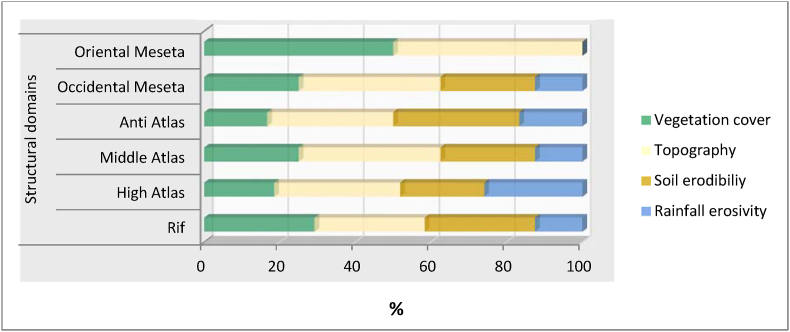
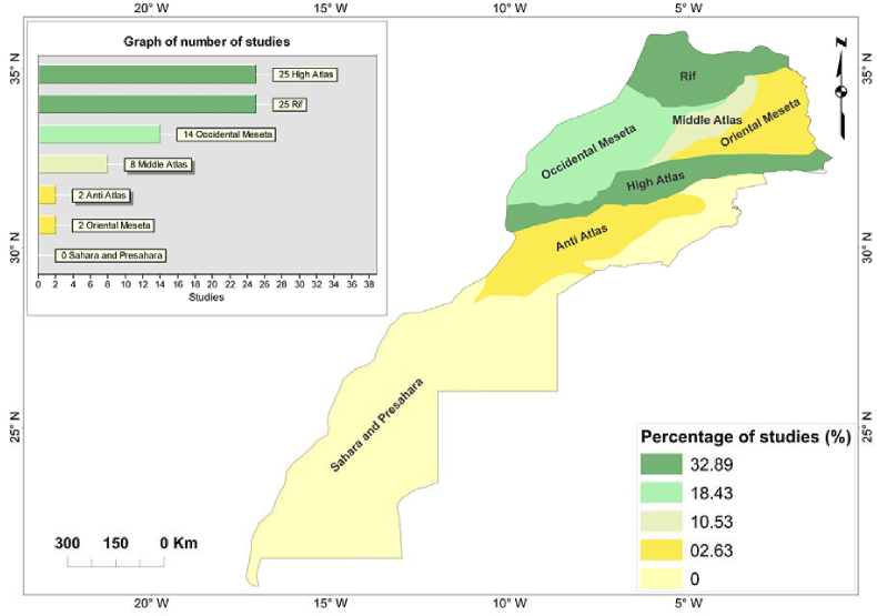
During the last century, a great deal of effort has been directed toward determining soil erosion rates using various methods under a wide range of climatic conditions, soil types, land uses, topography, and among others. Therefore, to better understand soil erosion studies in Morocco, a country with diverse physiography and climatic variations we undertook an analysis of national data of several soil erosion modeling and fingerprinting. The approach used for this research is a review of scientific articles, conference papers and thesis on soil erosion, focusing more on categorization of the different soil erosion models and other methods applied. The results reveal very interesting information as follows: (i) the distribution and frequency level of modeling and fingerprinting applications; the focus was on the north of the country: (Rif 32.89%, High Atlas 32.89%, Occidental Meseta 18.43% and Middle Atlas 10.53%), (ii) The (R) USLE models remain the most widely used models (51,32%) in Morocco, (iii) The support practice factor was severely lacking across the country, (iv) the highest erosion rate is concentrated in the Atlas and Rif mountains; and (v) a positive relationship between erosion rate and geological features, slope, climate, land use and cover, plus other environmental characteristics, as well as measurement and modeling conditions, and a negative relationship with the study areas size and scale. Even though the overall results show a high degree of variability, which cannot be explained by this combination of factors, but is at a minimum partly related to the experimental conditions. This overview research and database are designed to assist in the future assessment of soil erosion and to help define priorities for soil erosion research by providing a state of art for future focused and comprehensive analyses to address this issue of soil erosion in Morocco.

摘要

在上个世纪,人们付出了巨大努力,运用各种方法在广泛的气候条件、土壤类型、土地利用、地形等条件下测定土壤侵蚀速率。因此,为了更好地了解摩洛哥这个地形多样、气候变化丰富的国家的土壤侵蚀研究情况,我们对该国若干土壤侵蚀建模和指纹识别的国家数据进行了分析。本研究采用的方法是对有关土壤侵蚀的科学文章、会议论文和论文进行综述,更多地关注不同土壤侵蚀模型和其他应用方法的分类。结果揭示了非常有趣的信息如下:(i)建模和指纹识别应用的分布和频率水平;重点在该国北部地区(里夫地区占32.89%,高阿特拉斯地区占32.89%,西梅塞塔地区占18.43%,中阿特拉斯地区占10.53%),(ii)(R)通用土壤流失方程模型仍是摩洛哥使用最广泛的模型(51.32%),(iii)全国范围内严重缺乏支撑实践因子,(iv)最高侵蚀速率集中在阿特拉斯山脉和里夫山脉;以及(v)侵蚀速率与地质特征、坡度、气候、土地利用和覆盖以及其他环境特征以及测量和建模条件之间呈正相关,与研究区域的大小和规模呈负相关。尽管总体结果显示出高度的变异性,无法用这些因素的组合来解释,但至少部分与实验条件有关。这项概述性研究和数据库旨在通过提供未来针对性和全面分析的最新技术水平,协助未来对土壤侵蚀的评估,并帮助确定土壤侵蚀研究的优先事项,以解决摩洛哥的土壤侵蚀问题。

https://cdn.ncbi.nlm.nih.gov/pmc/blobs/378c/9421189/f31e76ffe5d1/gr4.jpg
https://cdn.ncbi.nlm.nih.gov/pmc/blobs/378c/9421189/cb0c4c1e0398/gr1.jpg
https://cdn.ncbi.nlm.nih.gov/pmc/blobs/378c/9421189/68ad68c72ce1/gr2.jpg
https://cdn.ncbi.nlm.nih.gov/pmc/blobs/378c/9421189/dec4eb970431/gr3.jpg
https://cdn.ncbi.nlm.nih.gov/pmc/blobs/378c/9421189/f31e76ffe5d1/gr4.jpg
https://cdn.ncbi.nlm.nih.gov/pmc/blobs/378c/9421189/cb0c4c1e0398/gr1.jpg
https://cdn.ncbi.nlm.nih.gov/pmc/blobs/378c/9421189/68ad68c72ce1/gr2.jpg
https://cdn.ncbi.nlm.nih.gov/pmc/blobs/378c/9421189/dec4eb970431/gr3.jpg
https://cdn.ncbi.nlm.nih.gov/pmc/blobs/378c/9421189/f31e76ffe5d1/gr4.jpg

相似文献

1
Soil water erosion assessment in Morocco through modeling and fingerprinting applications: A review.通过建模和指纹识别应用对摩洛哥土壤水蚀进行评估:综述
Heliyon. 2022 Aug 15;8(8):e10209. doi: 10.1016/j.heliyon.2022.e10209. eCollection 2022 Aug.
2
Assessment of soil erosion rates in a Mediterranean cultivated and uncultivated soils using fallout 137Cs.使用沉降 137Cs 评估地中海耕作和未耕作土壤的侵蚀速率。
J Environ Radioact. 2019 Nov;208-209:106021. doi: 10.1016/j.jenvrad.2019.106021. Epub 2019 Jul 26.
3
Spatial and temporal evaluation of soil erosion in Turkey under climate change scenarios using the Pan-European Soil Erosion Risk Assessment (PESERA) model.利用泛欧土壤侵蚀风险评估模型评估气候变化情景下土耳其土壤侵蚀的时空演变。
Environ Monit Assess. 2020 Jul 7;192(8):491. doi: 10.1007/s10661-020-08429-5.
4
Soil erosion modelling: A global review and statistical analysis.土壤侵蚀模型:全球综述与统计分析。
Sci Total Environ. 2021 Aug 1;780:146494. doi: 10.1016/j.scitotenv.2021.146494. Epub 2021 Mar 17.
5
Assessment of areal water and tillage erosion using magnetic susceptibility: the approach and its application in Moroccan watershed.利用磁化率评估面蚀和耕作侵蚀:方法及其在摩洛哥流域的应用。
Environ Sci Pollut Res Int. 2019 Sep;26(25):25452-25466. doi: 10.1007/s11356-019-05510-6. Epub 2019 Jul 1.
6
Soil erosion risk assessment and treatment priority classification: A case study on guder watersheds, Abay river basin, Oromia, Ethiopia.土壤侵蚀风险评估与治理优先级分类:以埃塞俄比亚奥罗米亚阿巴伊河流域古德河流域为例
Heliyon. 2022 Aug 10;8(8):e10183. doi: 10.1016/j.heliyon.2022.e10183. eCollection 2022 Aug.
7
Estimating erosion in a riverine watershed: Bayou Liberty-Tchefuncta River in Louisiana.估算河流水系流域的侵蚀情况:路易斯安那州的利伯蒂湾-切丰克塔河
Environ Sci Pollut Res Int. 2003;10(4):245-50. doi: 10.1065/espr2003.05.153.
8
Use of (137)Cs technique for soil erosion study in the agricultural region of Casablanca in Morocco.利用铯-137技术对摩洛哥卡萨布兰卡农业地区的土壤侵蚀进行研究。
J Environ Radioact. 2003;68(1):11-26. doi: 10.1016/S0265-931X(03)00025-0.
9
Effect of multiple climate change scenarios and predicted land-cover on soil erosion: a way forward for the better land management.多种气候变化情景和预测土地覆盖对土壤侵蚀的影响:更好的土地管理的一种途径。
Environ Monit Assess. 2021 Oct 28;193(11):754. doi: 10.1007/s10661-021-09559-0.
10
Spatial and temporal characteristics of soil conservation service in the area of the upper and middle of the Yellow River, China.中国黄河中上游地区土壤保持服务的时空特征
Heliyon. 2019 Dec 12;5(12):e02985. doi: 10.1016/j.heliyon.2019.e02985. eCollection 2019 Dec.

本文引用的文献

1
Suspended sediment load prediction using long short-term memory neural network.基于长短期记忆神经网络的悬浮泥沙负荷预测。
Sci Rep. 2021 Apr 9;11(1):7826. doi: 10.1038/s41598-021-87415-4.
2
Analysis and prediction of climate forecasts in Northern Morocco: application of multilevel linear mixed effects models using R software.摩洛哥北部气候预测的分析与预测:使用R软件的多层线性混合效应模型的应用
Heliyon. 2020 Oct 8;6(10):e05094. doi: 10.1016/j.heliyon.2020.e05094. eCollection 2020 Oct.
3
Land use and climate change impacts on global soil erosion by water (2015-2070).
土地利用和气候变化对全球水蚀土壤流失的影响(2015-2070 年)。
Proc Natl Acad Sci U S A. 2020 Sep 8;117(36):21994-22001. doi: 10.1073/pnas.2001403117. Epub 2020 Aug 24.
4
Assessment of soil erosion rates in a Mediterranean cultivated and uncultivated soils using fallout 137Cs.使用沉降 137Cs 评估地中海耕作和未耕作土壤的侵蚀速率。
J Environ Radioact. 2019 Nov;208-209:106021. doi: 10.1016/j.jenvrad.2019.106021. Epub 2019 Jul 26.
5
The CHRS Data Portal, an easily accessible public repository for PERSIANN global satellite precipitation data.CHRS 数据门户,一个易于访问的 PERSIANN 全球卫星降水数据公共存储库。
Sci Data. 2019 Jan 8;6:180296. doi: 10.1038/sdata.2018.296.
6
Erosion and Sediment Transport Modelling in Shallow Waters: A Review on Approaches, Models and Applications.浅水侵蚀与泥沙输移模拟:方法、模型及应用综述。
Int J Environ Res Public Health. 2018 Mar 14;15(3):518. doi: 10.3390/ijerph15030518.
7
An assessment of the global impact of 21st century land use change on soil erosion.评估 21 世纪土地利用变化对土壤侵蚀的全球影响。
Nat Commun. 2017 Dec 8;8(1):2013. doi: 10.1038/s41467-017-02142-7.
8
The WEPP Model Application in a Small Watershed in the Loess Plateau.WEPP模型在黄土高原小流域的应用
PLoS One. 2016 Mar 10;11(3):e0148445. doi: 10.1371/journal.pone.0148445. eCollection 2016.
9
Assessment of soil erosion and deposition rates in a Moroccan agricultural field using fallout 137Cs and 210Pbex.利用沉降 137Cs 和 210Pbex 评估摩洛哥农田的土壤侵蚀和沉积速率。
J Environ Radioact. 2013 Jan;115:97-106. doi: 10.1016/j.jenvrad.2012.07.013. Epub 2012 Aug 13.
10
Use of (137)Cs technique for soil erosion study in the agricultural region of Casablanca in Morocco.利用铯-137技术对摩洛哥卡萨布兰卡农业地区的土壤侵蚀进行研究。
J Environ Radioact. 2003;68(1):11-26. doi: 10.1016/S0265-931X(03)00025-0.