Instituto Mediterráneo de Estudios Avanzados, IMEDEA (CSIC-UIB), C/ Miquel Marquès, 21, Esporles, 07190, Illes Balears, Spain.
University Grenoble Alpes, CNRS, IRD, IGE, Grenoble, 38400, France.
Sci Rep. 2019 Jan 10;9(1):17775. doi: 10.1038/s41598-018-36819-w.
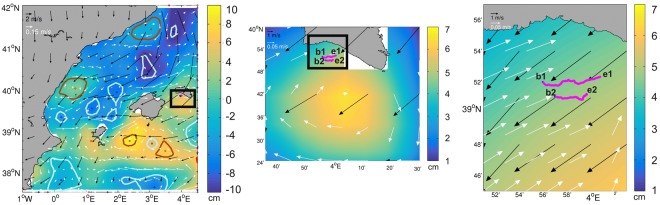
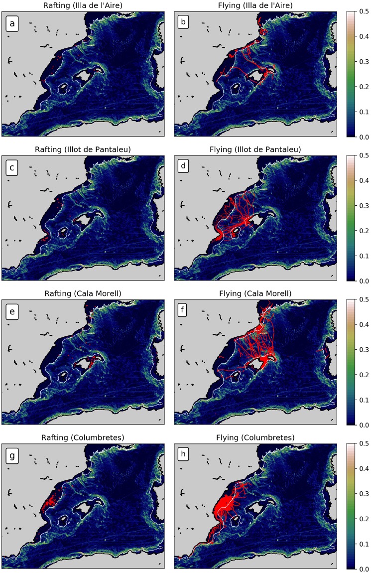
Spatio-temporal variability of surface geostrophic mesoscale currents in the Balearic Sea (western Mediterranean) is characterized from satellite altimetry in combination with in-situ velocity measurements collected, among others, by drifting buoys, gliders and high-frequency radar. Here, we explore the use of tracking data from living organisms in the Balearic Sea as an alternative way to acquire in-situ velocity measurements. Specifically, we use GPS-tracks of resting Scopoli's shearwaters Calonectris diomedea, that act as passive drifters, and compare them with satellite-derived velocity patterns. Results suggest that animal-borne GPS data can be used to identify rafting behaviour outside of the breeding colonies and, furthermore, as a proxy to describe local sea surface currents. Four rafting patterns were identified according to the prevailing driving forces responsible for the observed trajectories. We find that 76% of the bird trajectories are associated with the combined effects of slippage and Ekman drift and/or surface drag; 59% are directly driven by the sea surface currents. Shearwaters are therefore likely to be passively transported by these driving forces while resting. The tracks are generally consistent with the mesoscale features observed in satellite data and identified with eddy-tracking software.
巴利阿里海(西地中海)的表面地转中尺度海流的时空变化特征是利用卫星测高与漂流浮标、滑翔机和高频雷达等收集的现场速度测量相结合来描述的。在这里,我们探索了使用巴利阿里海生物的跟踪数据作为获取现场速度测量的替代方法。具体来说,我们使用了休息中的灰鹱(Calonectris diomedea)的 GPS 轨迹,它们充当被动漂流者,并将其与卫星得出的速度模式进行比较。结果表明,动物携带的 GPS 数据可用于识别繁殖地以外的漂流行为,并且可以作为描述当地海面流的替代物。根据观察到的轨迹的主要驱动力,确定了四种漂流模式。我们发现,76%的鸟类轨迹与滑移和埃克曼漂移以及/或表面阻力的综合影响有关;59%的轨迹直接受到海流的驱动。因此,在休息时,灰鹱很可能会被这些驱动力被动运输。这些轨迹与卫星数据中观察到的中尺度特征基本一致,并通过涡跟踪软件进行了识别。