Wang Feilong, Wang Fumin, Zhang Yao, Hu Jinghui, Huang Jingfeng, Xie Jingkai
Institute of Hydrology and Water Resources, Zhejiang University, Hangzhou, China.
Institute of Applied Remote Sensing & Information Technology, Zhejiang University, Hangzhou, China.
Front Plant Sci. 2019 Apr 10;10:453. doi: 10.3389/fpls.2019.00453. eCollection 2019.
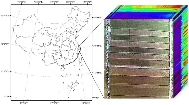
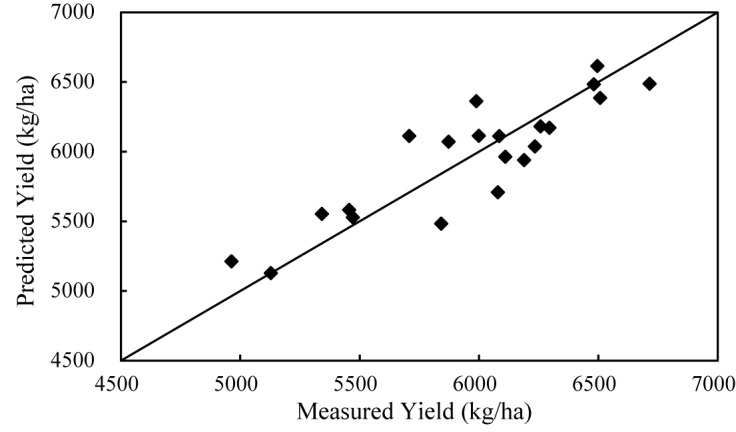
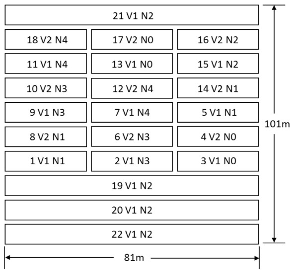
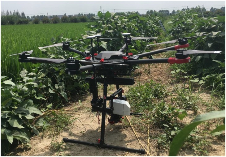
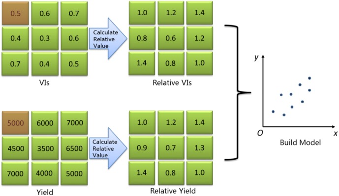
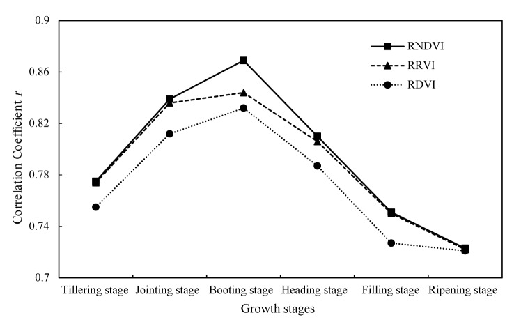
Time-series Vegetation Indices (VIs) are usually used for estimating grain yield. However, multi-temporal VIs may be affected by different background, illumination, and atmospheric conditions, so the absolute differences among time-series VIs may include the effects induced from external conditions in addition to vegetation changes, which will pose a negative effect on the accuracy of crop yield estimation. Therefore, in this study, the parcel-based relative vegetation index () and the parcel-based relative yield are proposed and further used to estimate rice yield. Hyperspectral images at key growth stages, including tillering stage, jointing stage, booting stage, heading stage, filling stage, and ripening stage, as well as rice yield, were obtained with Rikola hyperspectral imager mounted on Unmanned Aerial Vehicle (UAV) in 2017 growing season. Three types of parcel-level relative vegetation indices, including Relative Normalized Difference Vegetation Index (RNDVI), Relative Ratio Vegetation Index (RRVI), and Relative Difference Vegetation Index (RDVI) are created by using all possible two-band combinations of discrete channels from 500 to 900 nm. The optimal VI type and its band combinations at different growth stages are identified for rice yield estimation. Furthermore, the optimal combinations of different growth stages for yield estimation are determined by -test and validated using leave-one-out cross validation (LOOCV) method. The comparison results show that, for the single-growth-stage model, RNDVI at booting stage has the best correlation with rice yield with a -value of 0.75. For the multiple-growth-stage model, RNDVI at jointing stage, RNDVI at booting stage and RNDVI at filling stage gain a higher -value of 0.83 with the mean absolute percentage error of estimated rice yield of 3%. The study demonstrates that the proposed method with parcel-level relative vegetation indices and relative yield can achieve higher yield estimation accuracy because it can make full use of the advantage that remote sensing can monitor relative changes accurately. The new method will further enrich the technology system for crop yield estimation based on remotely sensed data.
时间序列植被指数(VIs)通常用于估算谷物产量。然而,多时相植被指数可能会受到不同背景、光照和大气条件的影响,因此时间序列植被指数之间的绝对差异除了植被变化外,还可能包括外部条件引起的影响,这将对作物产量估算的准确性产生负面影响。因此,在本研究中,提出了基于地块的相对植被指数()和基于地块的相对产量,并进一步用于估算水稻产量。2017年生长季,使用安装在无人机(UAV)上的Rikola高光谱成像仪获取了包括分蘖期、拔节期、孕穗期、抽穗期、灌浆期和成熟期在内的关键生长阶段的高光谱图像以及水稻产量。通过使用500至900nm离散通道的所有可能双波段组合,创建了三种类型的地块级相对植被指数,包括相对归一化差异植被指数(RNDVI)、相对比值植被指数(RRVI)和相对差异植被指数(RDVI)。确定了用于水稻产量估算的不同生长阶段的最佳植被指数类型及其波段组合。此外,通过检验确定了用于产量估算的不同生长阶段的最佳组合,并使用留一法交叉验证(LOOCV)方法进行了验证。比较结果表明,对于单生长阶段模型,孕穗期的RNDVI与水稻产量的相关性最好,值为0.75。对于多生长阶段模型,拔节期的RNDVI、孕穗期的RNDVI和灌浆期的RNDVI获得了更高的值0.83,估计水稻产量的平均绝对百分比误差为3%。该研究表明,所提出的基于地块级相对植被指数和相对产量的方法可以实现更高的产量估算精度,因为它可以充分利用遥感能够准确监测相对变化的优势。新方法将进一步丰富基于遥感数据的作物产量估算技术体系。