• 文献检索
  • 文档翻译
  • 深度研究
  • 学术资讯
  • Suppr Zotero 插件Zotero 插件
  • 邀请有礼
  • 套餐&价格
  • 历史记录
应用&插件
Suppr Zotero 插件Zotero 插件浏览器插件Mac 客户端Windows 客户端微信小程序
定价
高级版会员购买积分包购买API积分包
服务
文献检索文档翻译深度研究API 文档MCP 服务
关于我们
关于 Suppr公司介绍联系我们用户协议隐私条款
关注我们

Suppr 超能文献

核心技术专利:CN118964589B侵权必究
粤ICP备2023148730 号-1Suppr @ 2026

文献检索

告别复杂PubMed语法,用中文像聊天一样搜索,搜遍4000万医学文献。AI智能推荐,让科研检索更轻松。

立即免费搜索

文件翻译

保留排版,准确专业,支持PDF/Word/PPT等文件格式,支持 12+语言互译。

免费翻译文档

深度研究

AI帮你快速写综述,25分钟生成高质量综述,智能提取关键信息,辅助科研写作。

立即免费体验

监测发展中城市群区域热环境的详细动态。

Monitoring the Detailed Dynamics of Regional Thermal Environment in a Developing Urban Agglomeration.

机构信息

Three Gorges Research Center for Geo-hazard, Ministry of Education, China University of Geosciences, Wuhan 430074, China.

School of Earth Sciences, China University of Geosciences, Wuhan 430074, China.

出版信息

Sensors (Basel). 2020 Feb 21;20(4):1197. doi: 10.3390/s20041197.

DOI:10.3390/s20041197
PMID:32098254
原文链接:https://pmc.ncbi.nlm.nih.gov/articles/PMC7070637/
Abstract

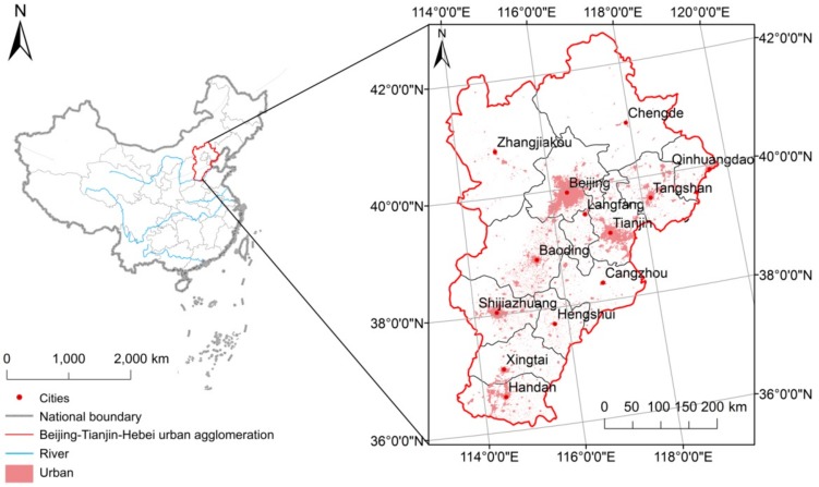
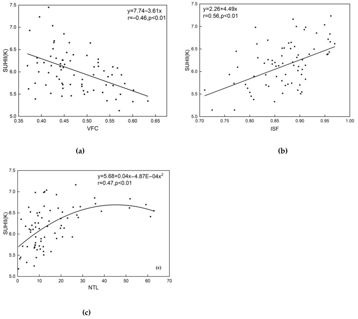
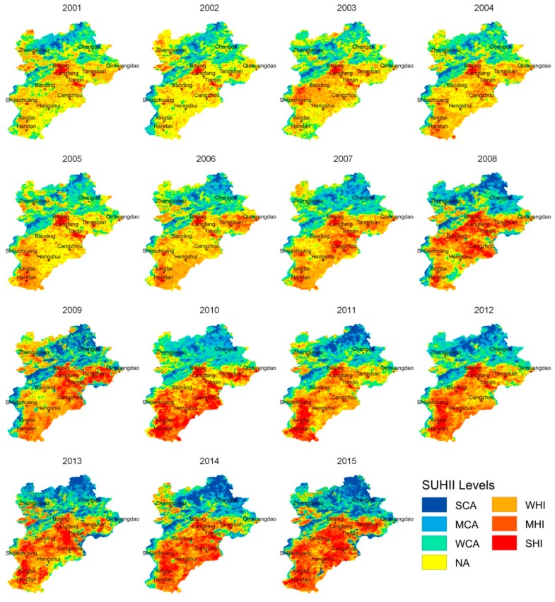
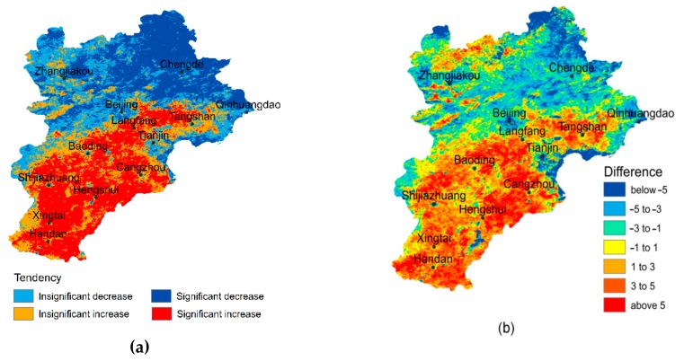
Many studies have revealed the characteristics and spatial-temporal dynamics of the thermal environment in specific cities or urban agglomerations (UA), as well as the associated determining factors. However, few studies focus on the changing relationships (the difference, distance, interaction, etc.) among inner cities' heat islands in a UA, which represent not only the detailed dynamics of regional thermal environment (RTE), but also the changing competition and cooperation among cities in a developing UA. In this study, we used Moderate Resolution Imaging Spectroradiometer (MODIS) land surface temperature (LST) products to map and analyze the detailed dynamics of the Beijing-Tianjin-Hebei (BTH) UA thermal environment. From 2001 to 2015, the mean surface urban heat island intensity (SUHII) of the BTH increased significantly, and the surface urban heat islands (SUHIs) in the southern BTH have rapidly increased, expanded and connected, eventually forming a large heat islands agglomeration. According to correlation analysis, urban sprawl probably led to the expansion and enhance of SUHIs in the south plain, while the forest has significantly alleviated urban heat island effect in northern mountains. The results expose the detailed evolution process of BTH thermal environment, and the changing relationships among the inner cities. In a developing UA, mitigation solutions (e.g., ecological corridors or controlling energy consumption) are in demand to stop the formation of a great heat region.

摘要

许多研究揭示了特定城市或城市群(UA)热环境的特征和时空动态,以及相关的决定因素。然而,很少有研究关注 UA 内城市热岛之间不断变化的关系(差异、距离、相互作用等),这些关系不仅代表了区域热环境(RTE)的详细动态,还代表了发展中的 UA 中城市之间竞争与合作的变化。在这项研究中,我们使用中分辨率成像光谱仪(MODIS)陆地表面温度(LST)产品来绘制和分析京津冀(BTH)UA 热环境的详细动态。从 2001 年到 2015 年,BTH 的平均地表城市热岛强度(SUHII)显著增加,BTH 南部的地表城市热岛(SUHIs)迅速增加、扩大和连接,最终形成了一个大的热岛聚集区。根据相关分析,城市扩张可能导致南部平原的 SUHIs 扩张和增强,而森林则显著缓解了北部山区的城市热岛效应。研究结果揭示了 BTH 热环境的详细演变过程以及城市内部的变化关系。在一个发展中的 UA 中,需要采取缓解措施(例如,生态走廊或控制能源消耗)来阻止一个大的热区的形成。

https://cdn.ncbi.nlm.nih.gov/pmc/blobs/82fa/7070637/52c059c62dd5/sensors-20-01197-g006.jpg
https://cdn.ncbi.nlm.nih.gov/pmc/blobs/82fa/7070637/3440fd6c2dc5/sensors-20-01197-g001.jpg
https://cdn.ncbi.nlm.nih.gov/pmc/blobs/82fa/7070637/8b72a9e8c8ac/sensors-20-01197-g002.jpg
https://cdn.ncbi.nlm.nih.gov/pmc/blobs/82fa/7070637/0cebbff1c4d1/sensors-20-01197-g003.jpg
https://cdn.ncbi.nlm.nih.gov/pmc/blobs/82fa/7070637/86206eff6b93/sensors-20-01197-g004.jpg
https://cdn.ncbi.nlm.nih.gov/pmc/blobs/82fa/7070637/9cacd98c32be/sensors-20-01197-g005.jpg
https://cdn.ncbi.nlm.nih.gov/pmc/blobs/82fa/7070637/52c059c62dd5/sensors-20-01197-g006.jpg

相似文献

1
Monitoring the Detailed Dynamics of Regional Thermal Environment in a Developing Urban Agglomeration.监测发展中城市群区域热环境的详细动态。
Sensors (Basel). 2020 Feb 21;20(4):1197. doi: 10.3390/s20041197.
2
A comparative study of land development patterns and regional thermal environments (RTEs) in typical urban agglomerations of China and America: A case study of Beijing-Tianjin-Hebei (BTH) and Boswash.中美典型城市群土地开发模式与区域热环境(RTE)的对比研究——以京津冀和波士华城市群为例
Sci Total Environ. 2022 Jan 10;803:149735. doi: 10.1016/j.scitotenv.2021.149735. Epub 2021 Aug 19.
3
Surface urban heat island and its relationship with land cover change in five urban agglomerations in China based on GEE.基于 GEE 的中国五个城市群的地表城市热岛及其与土地覆盖变化的关系。
Environ Sci Pollut Res Int. 2022 Nov;29(54):82271-82285. doi: 10.1007/s11356-022-21452-y. Epub 2022 Jun 24.
4
[Spatial Network of Urban Heat Environment in Beijing-Tianjin-Hebei Urban Agglomeration Based on MSPA and Circuit Theory].基于MSPA和电路理论的京津冀城市群城市热环境空间网络
Huan Jing Ke Xue. 2023 Jun 8;44(6):3034-3042. doi: 10.13227/j.hjkx.202206310.
5
Interannual variations in surface urban heat island intensity and associated drivers in China.中国地表城市热岛强度的年际变化及其相关驱动因素。
J Environ Manage. 2018 Sep 15;222:86-94. doi: 10.1016/j.jenvman.2018.05.024. Epub 2018 May 25.
6
Quantitative assessment and driving factors analysis of surface urban heat island of urban agglomerations in China based on GEE.基于 GEE 的中国城市群地表城市热岛的定量评估及驱动因子分析。
Environ Sci Pollut Res Int. 2024 Jul;31(34):47350-47364. doi: 10.1007/s11356-024-34205-w. Epub 2024 Jul 13.
7
How to reconcile land use conflicts in mega urban agglomeration? A scenario-based study in the Beijing-Tianjin-Hebei region, China.如何协调特大城市群的土地利用冲突?以中国京津冀地区为例的情景研究。
J Environ Manage. 2021 Oct 15;296:113168. doi: 10.1016/j.jenvman.2021.113168. Epub 2021 Jul 9.
8
Temporal trends of surface urban heat islands and associated determinants in major Chinese cities.中国主要城市地表城市热岛及其相关决定因素的时间变化趋势。
Sci Total Environ. 2017 Dec 31;609:742-754. doi: 10.1016/j.scitotenv.2017.07.217. Epub 2017 Jul 28.
9
Population-land urbanization and comprehensive development evaluation of the Beijing-Tianjin-Hebei urban agglomeration.京津冀城市群的人口-土地-城镇化与综合发展评价
Environ Sci Pollut Res Int. 2022 Aug;29(39):59862-59871. doi: 10.1007/s11356-022-20027-1. Epub 2022 Apr 9.
10
Scenario Modeling of Urbanization Development and Water Scarcity Based on System Dynamics: A Case Study of Beijing-Tianjin-Hebei Urban Agglomeration, China.基于系统动力学的城市化发展与水资源短缺情景模拟——以京津冀城市群为例。
Int J Environ Res Public Health. 2019 Oct 11;16(20):3834. doi: 10.3390/ijerph16203834.

引用本文的文献

1
Assessment of Summer Regional Outdoor Heat Stress and Regional Comfort in the Beijing-Tianjin-Hebei Agglomeration Over the Last 40 Years.过去40年京津冀城市群夏季区域户外热应激与区域舒适度评估
Geohealth. 2023 Jan 1;7(1):e2022GH000725. doi: 10.1029/2022GH000725. eCollection 2023 Jan.
2
Delineation of the Urban-Rural Boundary through Data Fusion: Applications to Improve Urban and Rural Environments and Promote Intensive and Healthy Urban Development.通过数据融合划定城乡边界:应用于改善城乡环境和促进集约健康城市发展。
Int J Environ Res Public Health. 2021 Jul 5;18(13):7180. doi: 10.3390/ijerph18137180.

本文引用的文献

1
The study of regional thermal environments in urban agglomerations using a new method based on metropolitan areas.基于大都市区的新方法对城市群区域热环境的研究。
Sci Total Environ. 2019 Jul 1;672:370-380. doi: 10.1016/j.scitotenv.2019.03.486. Epub 2019 Apr 1.
2
Global land change from 1982 to 2016.全球 1982 年至 2016 年土地变化情况。
Nature. 2018 Aug;560(7720):639-643. doi: 10.1038/s41586-018-0411-9. Epub 2018 Aug 8.
3
Remote sensing of the urban heat island effect in a highly populated urban agglomeration area in East China.
华东人口密集城市群城市热岛效应的遥感研究。
Sci Total Environ. 2018 Jul 1;628-629:415-429. doi: 10.1016/j.scitotenv.2018.02.074. Epub 2018 Feb 13.
4
Synergies between Urban Heat Island and Heat Waves in Athens (Greece), during an extremely hot summer (2012).雅典(希腊)极热夏季(2012 年)城市热岛与热浪之间的协同作用。
Sci Rep. 2017 Sep 8;7(1):10973. doi: 10.1038/s41598-017-11407-6.
5
Urbanization and the thermal environment of Chinese and US-American cities.城市化与中美城市的热环境
Sci Total Environ. 2017 Jul 1;589:200-211. doi: 10.1016/j.scitotenv.2017.02.148. Epub 2017 Mar 2.
6
Effects of landscape composition and pattern on land surface temperature: An urban heat island study in the megacities of Southeast Asia.景观组成和格局对地表温度的影响:东南亚特大城市热岛研究。
Sci Total Environ. 2017 Jan 15;577:349-359. doi: 10.1016/j.scitotenv.2016.10.195. Epub 2016 Nov 7.
7
Influences of land cover types, meteorological conditions, anthropogenic heat and urban area on surface urban heat island in the Yangtze River Delta Urban Agglomeration.长三角城市群地表城市热岛与土地覆盖类型、气象条件、人为热和城市面积的关系。
Sci Total Environ. 2016 Nov 15;571:461-70. doi: 10.1016/j.scitotenv.2016.07.012. Epub 2016 Jul 15.
8
The footprint of urban heat island effect in China.中国城市热岛效应的影响范围
Sci Rep. 2015 Jun 10;5:11160. doi: 10.1038/srep11160.
9
The urban heat island and its impact on heat waves and human health in Shanghai.上海市的城市热岛及其对热浪和人类健康的影响。
Int J Biometeorol. 2010 Jan;54(1):75-84. doi: 10.1007/s00484-009-0256-x.
10
The influence of demography and weak selection on the McDonald-Kreitman test: an empirical study in Drosophila.人口统计学和弱选择对麦克唐纳-克赖特曼检验的影响:果蝇的实证研究
Mol Biol Evol. 2009 Mar;26(3):691-8. doi: 10.1093/molbev/msn297. Epub 2009 Jan 6.