• 文献检索
  • 文档翻译
  • 深度研究
  • 学术资讯
  • Suppr Zotero 插件Zotero 插件
  • 邀请有礼
  • 套餐&价格
  • 历史记录
应用&插件
Suppr Zotero 插件Zotero 插件浏览器插件Mac 客户端Windows 客户端微信小程序
定价
高级版会员购买积分包购买API积分包
服务
文献检索文档翻译深度研究API 文档MCP 服务
关于我们
关于 Suppr公司介绍联系我们用户协议隐私条款
关注我们

Suppr 超能文献

核心技术专利:CN118964589B侵权必究
粤ICP备2023148730 号-1Suppr @ 2026

文献检索

告别复杂PubMed语法,用中文像聊天一样搜索,搜遍4000万医学文献。AI智能推荐,让科研检索更轻松。

立即免费搜索

文件翻译

保留排版,准确专业,支持PDF/Word/PPT等文件格式,支持 12+语言互译。

免费翻译文档

深度研究

AI帮你快速写综述,25分钟生成高质量综述,智能提取关键信息,辅助科研写作。

立即免费体验

日常活动地点 k-匿名化评估个体 GPS 数据集的披露风险。

Daily activity locations k-anonymity for the evaluation of disclosure risk of individual GPS datasets.

机构信息

Department of Geography, University of Toronto Mississauga, 3359 Mississauga Road, Mississauga, ON, L5L 1C6, Canada.

Department of Geography and Resource Management, The Chinese University of Hong Kong, Shatin, Hong Kong, China.

出版信息

Int J Health Geogr. 2020 Mar 5;19(1):7. doi: 10.1186/s12942-020-00201-9.

DOI:10.1186/s12942-020-00201-9
PMID:32138736
原文链接:https://pmc.ncbi.nlm.nih.gov/articles/PMC7059321/
Abstract

BACKGROUND

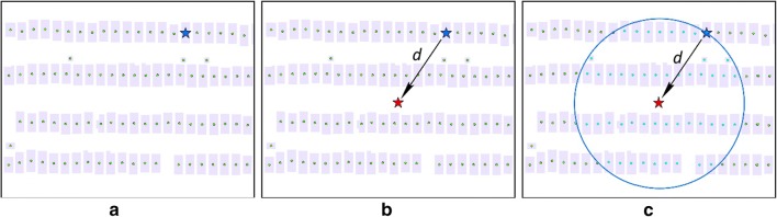
Personal privacy is a significant concern in the era of big data. In the field of health geography, personal health data are collected with geographic location information which may increase disclosure risk and threaten personal geoprivacy. Geomasking is used to protect individuals' geoprivacy by masking the geographic location information, and spatial k-anonymity is widely used to measure the disclosure risk after geomasking is applied. With the emergence of individual GPS trajectory datasets that contains large volumes of confidential geospatial information, disclosure risk can no longer be comprehensively assessed by the spatial k-anonymity method.

METHODS

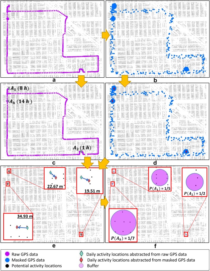
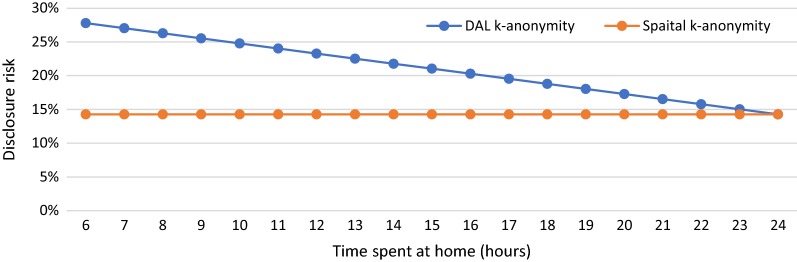
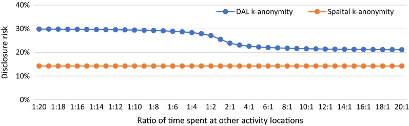
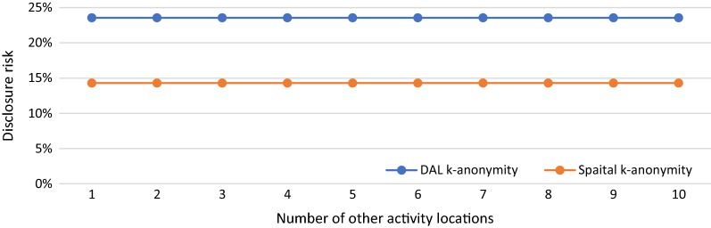
This study proposes and develops daily activity locations (DAL) k-anonymity as a new method for evaluating the disclosure risk of GPS data. Instead of calculating disclosure risk based on only one geographic location (e.g., home) of an individual, the new DAL k-anonymity is a composite evaluation of disclosure risk based on all activity locations of an individual and the time he/she spends at each location abstracted from GPS datasets. With a simulated individual GPS dataset, we present case studies of applying DAL k-anonymity in various scenarios to investigate its performance. The results of applying DAL k-anonymity are also compared with those obtained with spatial k-anonymity under these scenarios.

RESULTS

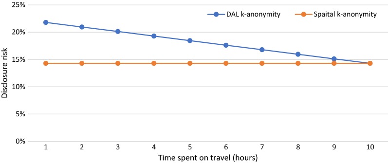
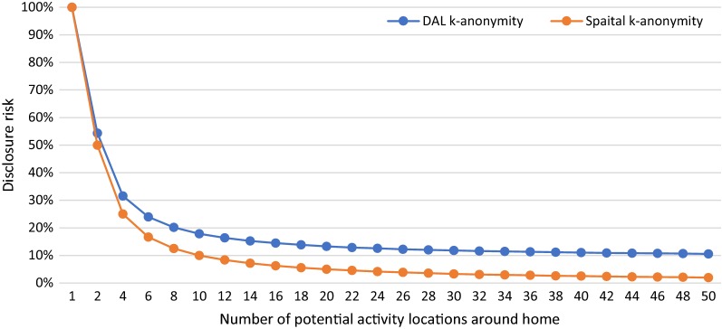
The results of this study indicate that DAL k-anonymity provides a better estimation of the disclosure risk than does spatial k-anonymity. In various case-study scenarios of individual GPS data, DAL k-anonymity provides a more effective method for evaluating the disclosure risk by considering the probability of re-identifying an individual's home and all the other daily activity locations.

CONCLUSIONS

This new method provides a quantitative means for understanding the disclosure risk of sharing or publishing GPS data. It also helps shed new light on the development of new geomasking methods for GPS datasets. Ultimately, the findings of this study will help to protect individual geoprivacy while benefiting the research community by promoting and facilitating geospatial data sharing.

摘要

背景

在大数据时代,个人隐私是一个重要的关注点。在健康地理学领域,个人健康数据与地理位置信息一起被收集,这可能会增加泄露风险并威胁个人地缘隐私。地理掩蔽技术被用来保护个人的地缘隐私,通过掩蔽地理位置信息,空间 k-匿名被广泛用于衡量地理掩蔽后的数据泄露风险。随着包含大量机密地理空间信息的个人 GPS 轨迹数据集的出现,空间 k-匿名方法已经不能全面评估泄露风险。

方法

本研究提出并开发了日常活动地点(DAL)k-匿名法,作为评估 GPS 数据泄露风险的新方法。新的 DAL k-匿名法不是基于个人的一个地理位置(例如,家庭)来计算泄露风险,而是基于从 GPS 数据集中提取的个人所有活动地点及其在每个地点停留的时间的综合评估。通过模拟个人 GPS 数据集,我们展示了在各种场景中应用 DAL k-匿名法的案例研究,以调查其性能。还在这些场景下比较了 DAL k-匿名法和空间 k-匿名法的结果。

结果

本研究结果表明,DAL k-匿名法比空间 k-匿名法提供了更好的泄露风险估计。在个人 GPS 数据的各种案例研究场景中,DAL k-匿名法通过考虑重新识别个人家庭和所有其他日常活动地点的概率,提供了一种更有效的评估泄露风险的方法。

结论

这种新方法为理解共享或发布 GPS 数据的泄露风险提供了一种定量手段。它还为开发新的 GPS 数据集地理掩蔽方法提供了新的思路。最终,本研究的发现将有助于保护个人地缘隐私,同时通过促进和便利地理空间数据共享,使研究社区受益。

https://cdn.ncbi.nlm.nih.gov/pmc/blobs/35a4/7059321/c03367131226/12942_2020_201_Fig8_HTML.jpg
https://cdn.ncbi.nlm.nih.gov/pmc/blobs/35a4/7059321/0152b6afb047/12942_2020_201_Fig1_HTML.jpg
https://cdn.ncbi.nlm.nih.gov/pmc/blobs/35a4/7059321/4e1b06ddfc3d/12942_2020_201_Fig2_HTML.jpg
https://cdn.ncbi.nlm.nih.gov/pmc/blobs/35a4/7059321/436a83feb1b5/12942_2020_201_Fig3_HTML.jpg
https://cdn.ncbi.nlm.nih.gov/pmc/blobs/35a4/7059321/0419870a9af4/12942_2020_201_Fig4_HTML.jpg
https://cdn.ncbi.nlm.nih.gov/pmc/blobs/35a4/7059321/ea0e113d67b5/12942_2020_201_Fig5_HTML.jpg
https://cdn.ncbi.nlm.nih.gov/pmc/blobs/35a4/7059321/48faafbd017b/12942_2020_201_Fig6_HTML.jpg
https://cdn.ncbi.nlm.nih.gov/pmc/blobs/35a4/7059321/574b6c738127/12942_2020_201_Fig7_HTML.jpg
https://cdn.ncbi.nlm.nih.gov/pmc/blobs/35a4/7059321/c03367131226/12942_2020_201_Fig8_HTML.jpg

相似文献

1
Daily activity locations k-anonymity for the evaluation of disclosure risk of individual GPS datasets.日常活动地点 k-匿名化评估个体 GPS 数据集的披露风险。
Int J Health Geogr. 2020 Mar 5;19(1):7. doi: 10.1186/s12942-020-00201-9.
2
Street masking: a network-based geographic mask for easily protecting geoprivacy.街头掩蔽:一种基于网络的地理掩蔽,用于轻松保护地理隐私。
Int J Health Geogr. 2020 Jul 6;19(1):26. doi: 10.1186/s12942-020-00219-z.
3
Why does geoprivacy matter? The scientific publication of confidential data presented on maps.地理隐私为何重要?地图上呈现的机密数据的科学出版物。
J Empir Res Hum Res Ethics. 2014 Oct;9(4):34-45. doi: 10.1177/1556264614544103. Epub 2014 Aug 11.
4
Exploring geomasking methods for geoprivacy: a pilot study in an environment with built features.探索地理隐私的地理掩蔽方法:在具有建成特征的环境中的试点研究。
Geospat Health. 2023 Oct 17;18(2). doi: 10.4081/gh.2023.1205.
5
The verified neighbor approach to geoprivacy: An improved method for geographic masking.验证邻居方法的地理隐私保护:地理掩蔽的改进方法。
J Expo Sci Environ Epidemiol. 2018 Mar;28(2):109-118. doi: 10.1038/jes.2017.17. Epub 2017 Sep 20.
6
A novel on-line spatial-temporal k-anonymity method for location privacy protection from sequence rules-based inference attacks.一种基于序列规则推理攻击的位置隐私保护新型在线时空k匿名方法。
PLoS One. 2017 Aug 2;12(8):e0182232. doi: 10.1371/journal.pone.0182232. eCollection 2017.
7
Mapping health data: improved privacy protection with donut method geomasking.健康数据映射:甜甜圈几何掩蔽法提升隐私保护
Am J Epidemiol. 2010 Nov 1;172(9):1062-9. doi: 10.1093/aje/kwq248. Epub 2010 Sep 3.
8
A Geoprivacy by Design Guideline for Research Campaigns That Use Participatory Sensing Data.针对使用参与式传感数据的研究活动的“设计中的地理隐私指南”
J Empir Res Hum Res Ethics. 2018 Jul;13(3):203-222. doi: 10.1177/1556264618759877. Epub 2018 Apr 23.
9
Spatiotemporal Mobility Based Trajectory Privacy-Preserving Algorithm in Location-Based Services.基于时空移动性的位置服务轨迹隐私保护算法。
Sensors (Basel). 2021 Mar 12;21(6):2021. doi: 10.3390/s21062021.
10
Statistical disclosure limitation of health data based on Pk-anonymity.基于Pk匿名性的健康数据统计披露限制
Stud Health Technol Inform. 2012;180:1117-9.

引用本文的文献

1
Explorative pedestrian mobility geolocated data from a citizen science experiment in a neighbourhood.来自某社区公民科学实验的探索性行人移动性地理定位数据。
Sci Data. 2025 Jun 19;12(1):1036. doi: 10.1038/s41597-025-05307-y.
2
Opportunities and shortcomings of AI for spatial epidemiology and health disparities research on aging and the life course.人工智能在老龄化和生命历程的空间流行病学和健康差异研究中的机遇和不足。
Health Place. 2024 Sep;89:103323. doi: 10.1016/j.healthplace.2024.103323. Epub 2024 Jul 23.
3
Home-to-school pedestrian mobility GPS data from a citizen science experiment in the Barcelona area.

本文引用的文献

1
An Analytical Framework for Integrating the Spatiotemporal Dynamics of Environmental Context and Individual Mobility in Exposure Assessment: A Study on the Relationship between Food Environment Exposures and Body Weight.环境上下文和个体移动性时空动态整合的分析框架在暴露评估中的应用:食品环境暴露与体重关系的研究。
Int J Environ Res Public Health. 2018 Sep 15;15(9):2022. doi: 10.3390/ijerph15092022.
2
An Innovative Context-Based Crystal-Growth Activity Space Method for Environmental Exposure Assessment: A Study Using GIS and GPS Trajectory Data Collected in Chicago.基于创新语境的晶体生长活动空间方法在环境暴露评估中的应用:基于 GIS 和 GPS 轨迹数据在芝加哥的研究
Int J Environ Res Public Health. 2018 Apr 9;15(4):703. doi: 10.3390/ijerph15040703.
3
来自巴塞罗那地区公民科学实验的家到学校行人移动性 GPS 数据。
Sci Data. 2023 Jul 4;10(1):428. doi: 10.1038/s41597-023-02328-3.
4
The utility of Zip4 codes in spatial epidemiological analysis.Zip4 码在空间流行病学分析中的应用。
PLoS One. 2023 May 31;18(5):e0285552. doi: 10.1371/journal.pone.0285552. eCollection 2023.
5
LBS user location privacy protection scheme based on trajectory similarity.基于轨迹相似度的 LBS 用户位置隐私保护方案。
Sci Rep. 2022 Aug 17;12(1):13982. doi: 10.1038/s41598-022-18268-8.
Within What Distance Does "Greenness" Best Predict Physical Health? A Systematic Review of Articles with GIS Buffer Analyses across the Lifespan.“绿色度”能最佳预测身体健康的距离范围是多少?对全生命周期内采用地理信息系统缓冲区分析的文章进行的系统综述。
Int J Environ Res Public Health. 2017 Jun 23;14(7):675. doi: 10.3390/ijerph14070675.
4
Ensuring Confidentiality of Geocoded Health Data: Assessing Geographic Masking Strategies for Individual-Level Data.确保地理编码健康数据的保密性:评估个体层面数据的地理掩码策略。
Adv Med. 2014;2014:567049. doi: 10.1155/2014/567049. Epub 2014 Apr 29.
5
Reproducibility.可重复性
Science. 2014 Jan 17;343(6168):229. doi: 10.1126/science.1250475.
6
Detecting activity locations from raw GPS data: a novel kernel-based algorithm.从原始 GPS 数据中检测活动地点:一种新的基于核的算法。
Int J Health Geogr. 2013 Mar 16;12:14. doi: 10.1186/1476-072X-12-14.
7
Conceptualization and measurement of environmental exposure in epidemiology: accounting for activity space related to daily mobility.流行病学中环境暴露的概念化和测量:考虑与日常活动相关的活动空间。
Health Place. 2013 May;21:86-93. doi: 10.1016/j.healthplace.2013.01.005. Epub 2013 Feb 4.
8
Geomasking sensitive health data and privacy protection: an evaluation using an E911 database.地理掩码保护敏感健康数据与隐私:基于E911数据库的评估
Geocarto Int. 2010 Oct 1;25(6):443-452. doi: 10.1080/10106049.2010.496496.
9
Mapping health data: improved privacy protection with donut method geomasking.健康数据映射:甜甜圈几何掩蔽法提升隐私保护
Am J Epidemiol. 2010 Nov 1;172(9):1062-9. doi: 10.1093/aje/kwq248. Epub 2010 Sep 3.
10
Conceptualizing the healthscape: contributions of time geography, location technologies and spatial ecology to place and health research.概念化健康景观:时间地理学、位置技术和空间生态学对场所与健康研究的贡献。
Soc Sci Med. 2010 Mar;70(5):668-76. doi: 10.1016/j.socscimed.2009.10.035. Epub 2009 Dec 4.