• 文献检索
  • 文档翻译
  • 深度研究
  • 学术资讯
  • Suppr Zotero 插件Zotero 插件
  • 邀请有礼
  • 套餐&价格
  • 历史记录
应用&插件
Suppr Zotero 插件Zotero 插件浏览器插件Mac 客户端Windows 客户端微信小程序
定价
高级版会员购买积分包购买API积分包
服务
文献检索文档翻译深度研究API 文档MCP 服务
关于我们
关于 Suppr公司介绍联系我们用户协议隐私条款
关注我们

Suppr 超能文献

核心技术专利:CN118964589B侵权必究
粤ICP备2023148730 号-1Suppr @ 2026

文献检索

告别复杂PubMed语法,用中文像聊天一样搜索,搜遍4000万医学文献。AI智能推荐,让科研检索更轻松。

立即免费搜索

文件翻译

保留排版,准确专业,支持PDF/Word/PPT等文件格式,支持 12+语言互译。

免费翻译文档

深度研究

AI帮你快速写综述,25分钟生成高质量综述,智能提取关键信息,辅助科研写作。

立即免费体验

自主水面船舶用于监测应用的局部路径规划技术比较:亚帕克瑞亚湖案例研究。

A Comparison of Local Path Planning Techniques of Autonomous Surface Vehicles for Monitoring Applications: The Ypacarai Lake Case-study.

机构信息

Facultad de Ingeniería, Universidad Nacional de Asunción, 2160 San Lorenzo, Paraguay.

Universidad de Sevilla, 41004 Sevilla, Espana.

出版信息

Sensors (Basel). 2020 Mar 9;20(5):1488. doi: 10.3390/s20051488.

DOI:10.3390/s20051488
PMID:32182737
原文链接:https://pmc.ncbi.nlm.nih.gov/articles/PMC7085648/
Abstract

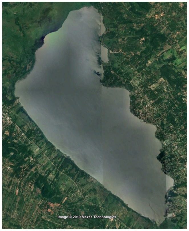
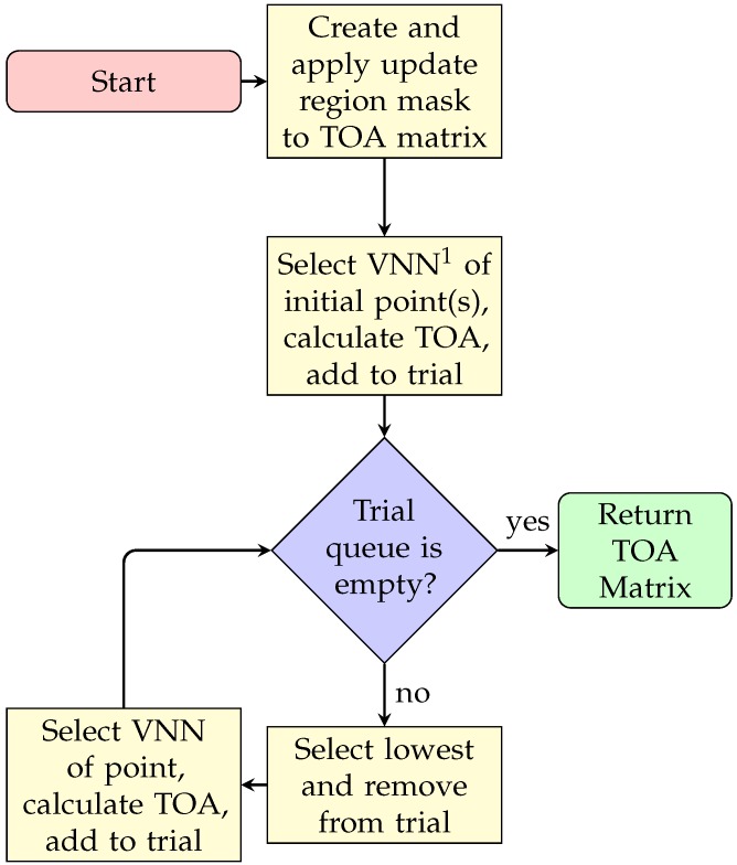
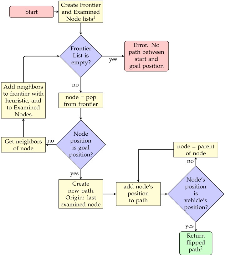
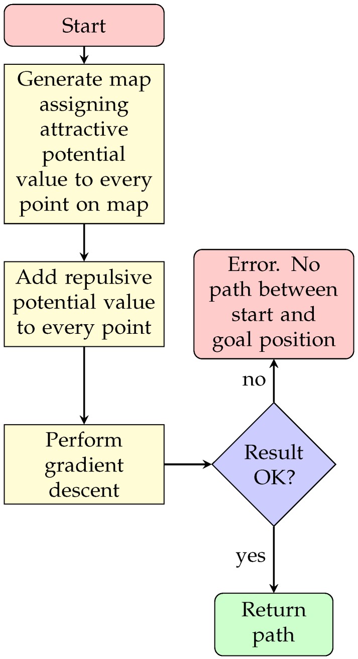
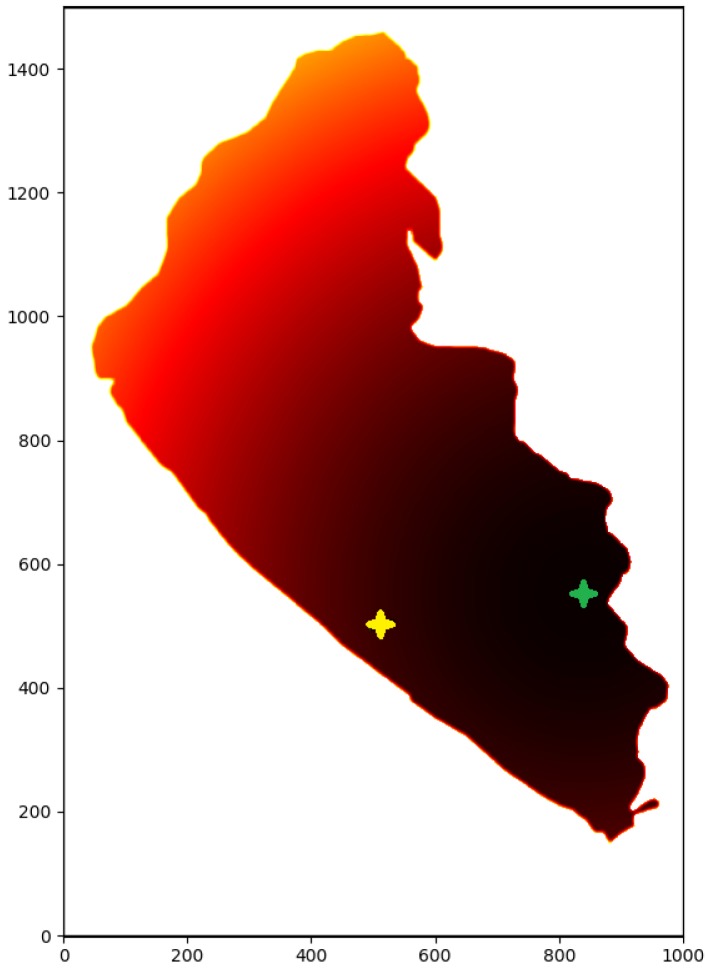
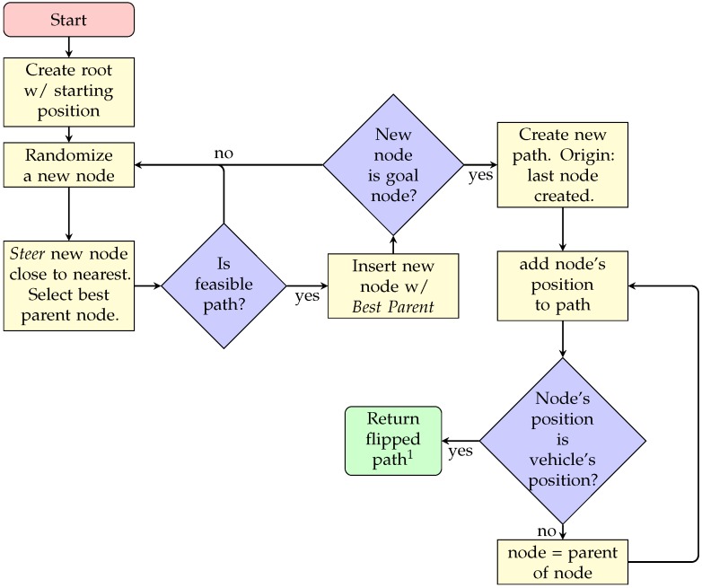
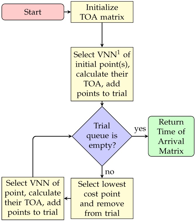
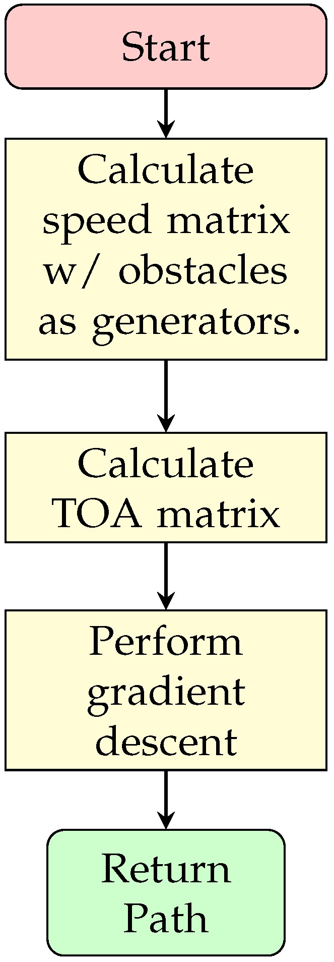
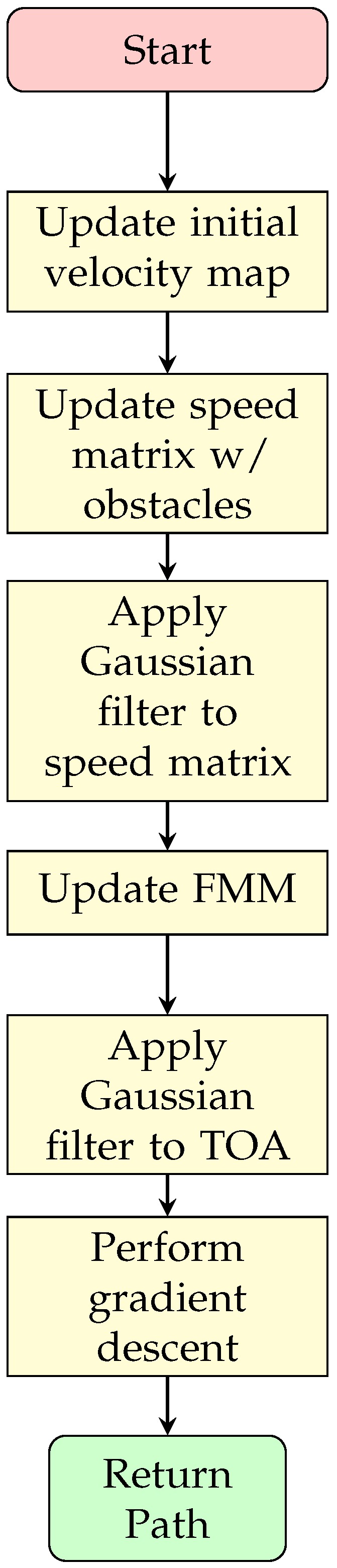
Local path planning is important in the development of autonomous vehicles since it allows a vehicle to adapt their movements to dynamic environments, for instance, when obstacles are detected. This work presents an evaluation of the performance of different local path planning techniques for an Autonomous Surface Vehicle, using a custom-made simulator based on the open-source Robotarium framework. The conducted simulations allow to verify, compare and visualize the solutions of the different techniques. The selected techniques for evaluation include A*, Potential Fields (PF), Rapidly-Exploring Random Trees* (RRT*) and variations of the Fast Marching Method (FMM), along with a proposed new method called Updating the Fast Marching Square method (uFMS). The evaluation proposed in this work includes ways to summarize time and safety measures for local path planning techniques. The results in a Lake environment present the advantages and disadvantages of using each technique. The proposed uFMS and A* have been shown to achieve interesting performance in terms of processing time, distance travelled and security levels. Furthermore, the proposed uFMS algorithm is capable of generating smoother routes.

摘要

局部路径规划在自动驾驶汽车的发展中非常重要,因为它允许车辆根据动态环境调整行驶路线,例如,当检测到障碍物时。本工作使用基于开源 Robotarium 框架的定制模拟器,对自主水面车辆的不同局部路径规划技术的性能进行了评估。所进行的模拟允许验证、比较和可视化不同技术的解决方案。选择用于评估的技术包括 A*、势场 (PF)、快速探索随机树* (RRT*) 和快速行进方法 (FMM) 的变体,以及一种称为更新快速行进方方法 (uFMS) 的新方法。这项工作提出的评估方法包括总结局部路径规划技术的时间和安全措施的方法。在湖泊环境中的结果展示了每种技术的优缺点。所提出的 uFMS 和 A* 在处理时间、行驶距离和安全水平方面表现出了有趣的性能。此外,所提出的 uFMS 算法能够生成更平滑的路线。

https://cdn.ncbi.nlm.nih.gov/pmc/blobs/d180/7085648/8f47825cae87/sensors-20-01488-g010.jpg
https://cdn.ncbi.nlm.nih.gov/pmc/blobs/d180/7085648/574241562858/sensors-20-01488-g001.jpg
https://cdn.ncbi.nlm.nih.gov/pmc/blobs/d180/7085648/dd9930f6a890/sensors-20-01488-g002.jpg
https://cdn.ncbi.nlm.nih.gov/pmc/blobs/d180/7085648/f439fdbe0908/sensors-20-01488-g003.jpg
https://cdn.ncbi.nlm.nih.gov/pmc/blobs/d180/7085648/134dc68dbc26/sensors-20-01488-g004.jpg
https://cdn.ncbi.nlm.nih.gov/pmc/blobs/d180/7085648/643898400b94/sensors-20-01488-g005.jpg
https://cdn.ncbi.nlm.nih.gov/pmc/blobs/d180/7085648/4a80430117c5/sensors-20-01488-g006.jpg
https://cdn.ncbi.nlm.nih.gov/pmc/blobs/d180/7085648/43e403d0bfc9/sensors-20-01488-g007.jpg
https://cdn.ncbi.nlm.nih.gov/pmc/blobs/d180/7085648/d2c6d39862a9/sensors-20-01488-g008.jpg
https://cdn.ncbi.nlm.nih.gov/pmc/blobs/d180/7085648/0507c0351c9e/sensors-20-01488-g009.jpg
https://cdn.ncbi.nlm.nih.gov/pmc/blobs/d180/7085648/8f47825cae87/sensors-20-01488-g010.jpg

相似文献

1
A Comparison of Local Path Planning Techniques of Autonomous Surface Vehicles for Monitoring Applications: The Ypacarai Lake Case-study.自主水面船舶用于监测应用的局部路径规划技术比较:亚帕克瑞亚湖案例研究。
Sensors (Basel). 2020 Mar 9;20(5):1488. doi: 10.3390/s20051488.
2
Development of an Improved Rapidly Exploring Random Trees Algorithm for Static Obstacle Avoidance in Autonomous Vehicles.一种用于自动驾驶车辆静态避障的改进型快速扩展随机树算法的开发。
Sensors (Basel). 2021 Mar 23;21(6):2244. doi: 10.3390/s21062244.
3
A Method on Dynamic Path Planning for Robotic Manipulator Autonomous Obstacle Avoidance Based on an Improved RRT Algorithm.一种基于改进RRT算法的机器人操作臂自主避障动态路径规划方法。
Sensors (Basel). 2018 Feb 13;18(2):571. doi: 10.3390/s18020571.
4
Research on Autonomous Vehicle Path Planning Algorithm Based on Improved RRT* Algorithm and Artificial Potential Field Method.基于改进RRT*算法和人工势场法的自动驾驶车辆路径规划算法研究
Sensors (Basel). 2024 Jun 16;24(12):3899. doi: 10.3390/s24123899.
5
Rapid global path planning algorithm for unmanned surface vehicles in large-scale and multi-island marine environments.面向大规模多岛屿海洋环境的无人水面舰艇快速全局路径规划算法
PeerJ Comput Sci. 2021 Jun 29;7:e612. doi: 10.7717/peerj-cs.612. eCollection 2021.
6
Motion planning for autonomous vehicle based on radial basis function neural network in unstructured environment.基于径向基函数神经网络的非结构化环境下自动驾驶车辆运动规划
Sensors (Basel). 2014 Sep 18;14(9):17548-66. doi: 10.3390/s140917548.
7
Local Path Planning of Autonomous Vehicle Based on an Improved Heuristic Bi-RRT Algorithm in Dynamic Obstacle Avoidance Environment.基于改进启发式双向快速扩展随机树算法的动态避障环境下自动驾驶车辆局部路径规划
Sensors (Basel). 2022 Oct 19;22(20):7968. doi: 10.3390/s22207968.
8
Cooperative path planning of multiple autonomous underwater vehicles operating in dynamic ocean environment.多自主水下机器人在动态海洋环境中的协同路径规划。
ISA Trans. 2019 Nov;94:174-186. doi: 10.1016/j.isatra.2019.04.012. Epub 2019 Apr 26.
9
A Study on Dynamic Motion Planning for Autonomous Vehicles Based on Nonlinear Vehicle Model.基于非线性车辆模型的自主车辆动态运动规划研究
Sensors (Basel). 2022 Dec 31;23(1):443. doi: 10.3390/s23010443.
10
Complex Environment Path Planning for Unmanned Aerial Vehicles.复杂环境下的无人机路径规划。
Sensors (Basel). 2021 Aug 3;21(15):5250. doi: 10.3390/s21155250.

引用本文的文献

1
A survey on autonomous environmental monitoring approaches: towards unifying active sensing and reinforcement learning.自主环境监测方法综述:迈向主动感知与强化学习的统一
Front Robot AI. 2024 Mar 12;11:1336612. doi: 10.3389/frobt.2024.1336612. eCollection 2024.
2
A Dimensional Comparison between Evolutionary Algorithm and Deep Reinforcement Learning Methodologies for Autonomous Surface Vehicles with Water Quality Sensors.具有水质传感器的自主水面车辆的进化算法与深度强化学习方法的维度比较。
Sensors (Basel). 2021 Apr 19;21(8):2862. doi: 10.3390/s21082862.
3
Learning-Based Autonomous UAV System for Electrical and Mechanical (E&M) Device Inspection.

本文引用的文献

1
Uncertainty Characterisation of Mobile Robot Localisation Techniques using Optical Surveying Grade Instruments.使用光学测量级仪器对移动机器人定位技术进行不确定性特征描述。
Sensors (Basel). 2018 Jul 13;18(7):2274. doi: 10.3390/s18072274.
2
A fast marching level set method for monotonically advancing fronts.一种用于单调推进前沿的快速行进水平集方法。
Proc Natl Acad Sci U S A. 1996 Feb 20;93(4):1591-5. doi: 10.1073/pnas.93.4.1591.
基于学习的自主无人机系统,用于电气和机械(E&M)设备检测。
Sensors (Basel). 2021 Feb 16;21(4):1385. doi: 10.3390/s21041385.
4
Indoor Path-Planning Algorithm for UAV-Based Contact Inspection.基于无人机的接触式检测的室内路径规划算法
Sensors (Basel). 2021 Jan 18;21(2):642. doi: 10.3390/s21020642.