Payo Andres, Mukhopadhyay Anirban, Hazra Sugata, Ghosh Tuhin, Ghosh Subhajit, Brown Sally, Nicholls Robert J, Bricheno Lucy, Wolf Judith, Kay Susan, Lázár Attila N, Haque Anisul
1University of Southampton, Southampton, SO17 1BJ UK.
2School of Oceanographic Studies, Jadavpur University, Kolkata, 700 032 India.
Clim Change. 2016;139(2):279-291. doi: 10.1007/s10584-016-1769-z. Epub 2016 Aug 16.
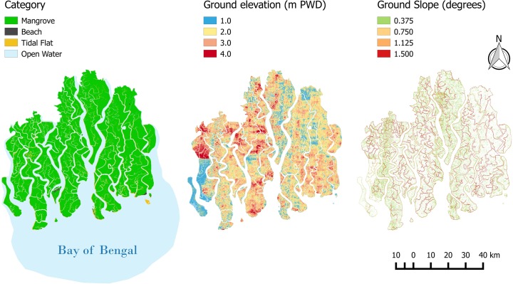
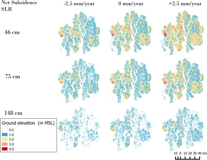
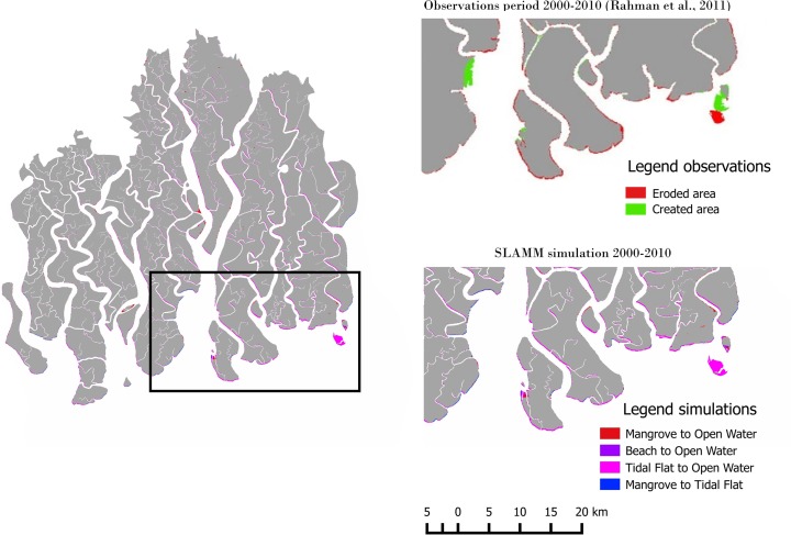
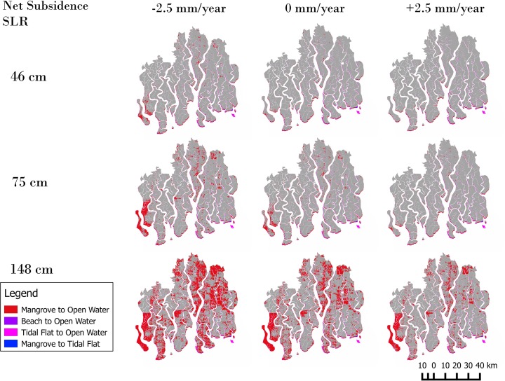
The Sundarbans mangrove ecosystem, located in India and Bangladesh, is recognized as a global priority for biodiversity conservation and is an important provider of ecosystem services such as numerous goods and protection against storm surges. With global mean sea-level rise projected as up to 0.98 m or greater by 2100 relative to the baseline period (1985-2005), the Sundarbans - mean elevation presently approximately 2 m above mean sea-level - is under threat from inundation and subsequent wetland loss; however the magnitude of loss remains unclear. We used remote and field measurements, geographic information systems and simulation modelling to investigate the potential effects of three sea-level rise scenarios on the Sundarbans within coastal Bangladesh. We illustrate how the Sea Level Affecting Marshes Model (SLAMM) is able to reproduce the observed area losses for the period 2000-2010. Using this calibrated model and assuming that mean sea-level is a better proxy than the SLAMM assumed mean lower low water for Mangrove area delineation, the estimated mangrove area net losses (relative to year 2000) are 81-178 km, 111-376 km and 583-1393 km for relative sea-level rise scenarios to 2100 of 0.46 m, 0.75 m and 1.48 m, respectively and net subsidence of ±2.5 mm/year. These area losses are very small (<10 % of present day area) and significantly smaller than previous research has suggested. Our simulations also suggest that erosion rather than inundation may remain the dominant loss driver to 2100 under certain scenarios of sea-level rise and net subsidence. Only under the highest scenarios does inundation due to sea-level rise become the dominant loss process.
孙德尔本斯红树林生态系统位于印度和孟加拉国,被视为全球生物多样性保护的重点区域,也是众多生态系统服务的重要提供者,比如提供大量物产以及抵御风暴潮。预计到2100年,全球平均海平面相对于基准期(1985 - 2005年)将上升高达0.98米甚至更多,而目前平均海拔约为海平面以上2米的孙德尔本斯正面临被淹没以及随之而来的湿地丧失的威胁;然而,损失的规模仍不明确。我们利用遥感和实地测量、地理信息系统以及模拟建模,来研究三种海平面上升情景对孟加拉国沿海孙德尔本斯地区的潜在影响。我们阐述了海平面影响沼泽模型(SLAMM)如何能够再现2000 - 2010年期间观测到的面积损失情况。使用这个校准后的模型,并假设平均海平面比SLAMM在划定红树林区域时所假定的平均低低潮位是更好的替代指标,对于到2100年相对海平面上升情景分别为0.46米、0.75米和1.48米且年净沉降为±2.5毫米的情况,估计红树林面积净损失(相对于2000年)分别为81 - 178平方千米、111 - 376平方千米和583 - 1393平方千米。这些面积损失非常小(不到当前面积的10%),且明显小于先前研究所表明的情况。我们的模拟还表明,在某些海平面上升和净沉降情景下,到2100年侵蚀而非淹没可能仍是主要的损失驱动因素。只有在最高情景下,海平面上升导致的淹没才会成为主要的损失过程。