• 文献检索
  • 文档翻译
  • 深度研究
  • 学术资讯
  • Suppr Zotero 插件Zotero 插件
  • 邀请有礼
  • 套餐&价格
  • 历史记录
应用&插件
Suppr Zotero 插件Zotero 插件浏览器插件Mac 客户端Windows 客户端微信小程序
定价
高级版会员购买积分包购买API积分包
服务
文献检索文档翻译深度研究API 文档MCP 服务
关于我们
关于 Suppr公司介绍联系我们用户协议隐私条款
关注我们

Suppr 超能文献

核心技术专利:CN118964589B侵权必究
粤ICP备2023148730 号-1Suppr @ 2026

文献检索

告别复杂PubMed语法,用中文像聊天一样搜索,搜遍4000万医学文献。AI智能推荐,让科研检索更轻松。

立即免费搜索

文件翻译

保留排版,准确专业,支持PDF/Word/PPT等文件格式,支持 12+语言互译。

免费翻译文档

深度研究

AI帮你快速写综述,25分钟生成高质量综述,智能提取关键信息,辅助科研写作。

立即免费体验

在夜间卫星图像中检测到的城市附近漫射光的性质。

The nature of the diffuse light near cities detected in nighttime satellite imagery.

作者信息

Sanchez de Miguel Alejandro, Kyba Christopher C M, Zamorano Jaime, Gallego Jesús, Gaston Kevin J

机构信息

Environment and Sustainability Institute, University of Exeter, Penryn, Cornwall, TR10 9FE, UK.

Department Física de la Tierra y Astrofísica and Instituto de Física de partículas y del Cosmos IPARCOS, Universidad Complutense de Madrid, Madrid, 28040, Spain.

出版信息

Sci Rep. 2020 May 8;10(1):7829. doi: 10.1038/s41598-020-64673-2.

DOI:10.1038/s41598-020-64673-2
PMID:32385403
原文链接:https://pmc.ncbi.nlm.nih.gov/articles/PMC7211018/
Abstract

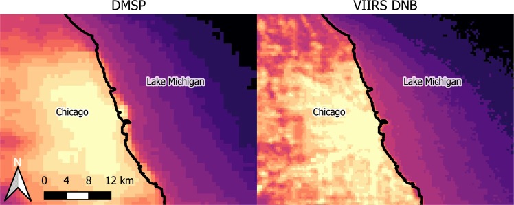
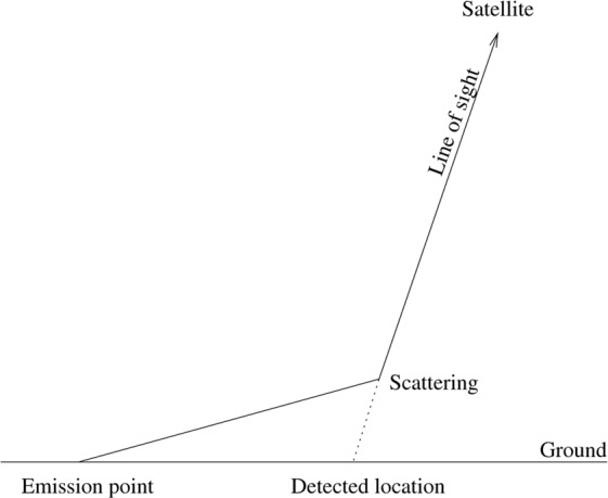
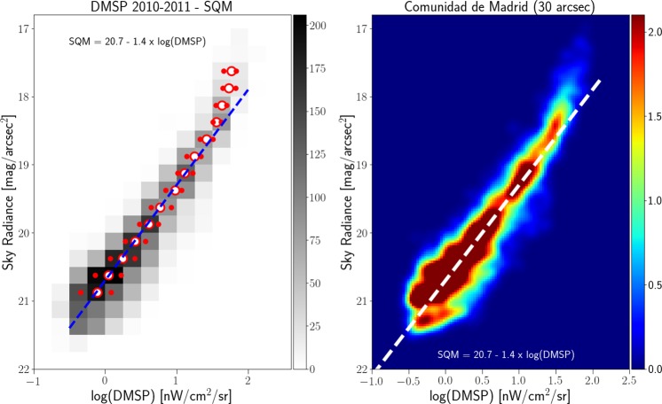
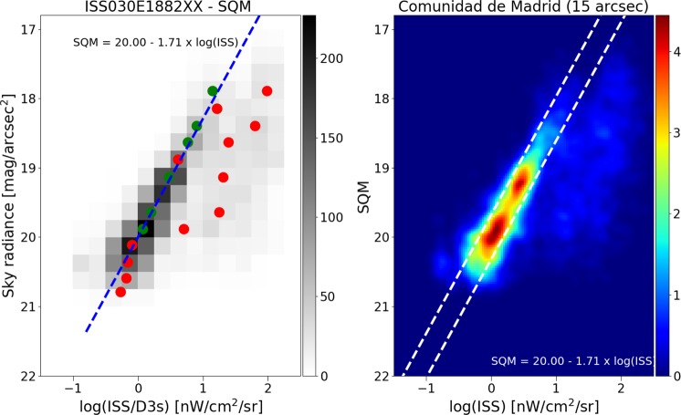
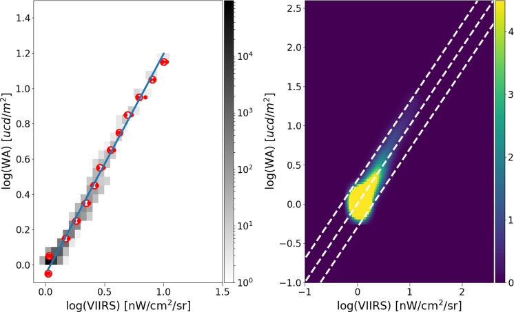
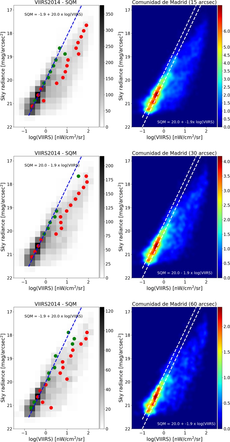
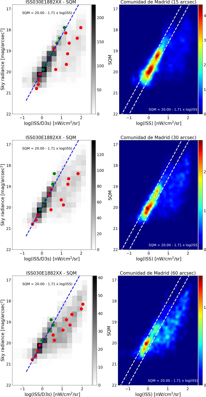
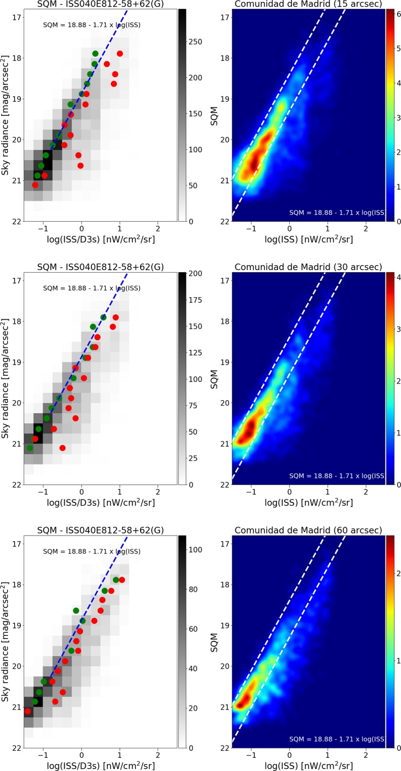
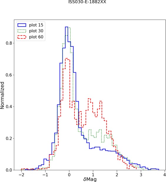
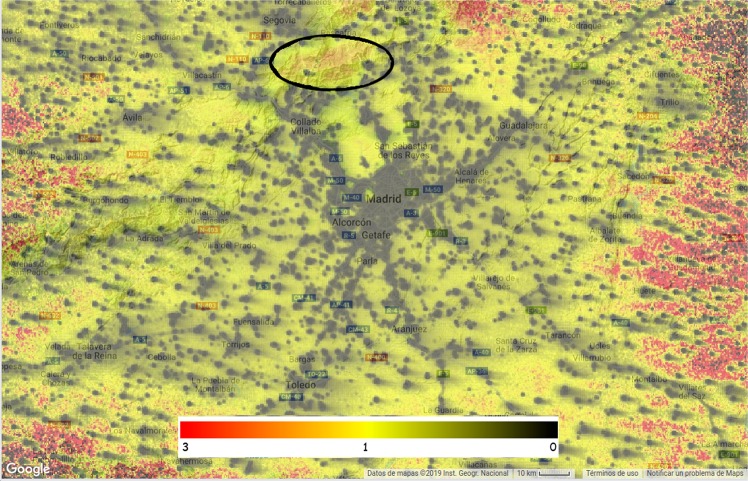
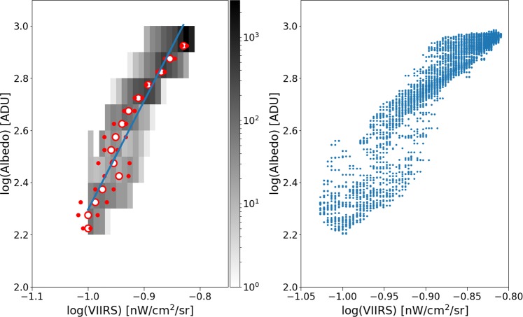
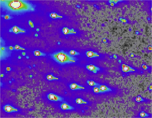
Diffuse glow has been observed around brightly lit cities in nighttime satellite imagery since at least the first publication of large scale maps in the late 1990s. In the literature, this has often been assumed to be an error related to the sensor, and referred to as "blooming", presumably in relation to the effect that can occur when using a CCD to photograph a bright light source. Here we show that the effect seen on the DMSP/OLS, SNPP/VIIRS-DNB and ISS is not only instrumental, but in fact represents a real detection of light scattered by the atmosphere. Data from the Universidad Complutense Madrid sky brightness survey are compared to nighttime imagery from multiple sensors with differing spatial resolutions, and found to be strongly correlated. These results suggest that it should be possible for a future space-based imaging radiometer to monitor changes in the diffuse artificial skyglow of cities.

摘要

至少自20世纪90年代末首次发布大规模地图以来,在夜间卫星图像中,人们就观察到明亮城市周围存在漫射辉光。在文献中,这通常被认为是与传感器相关的误差,并被称为“光晕”,大概是与使用电荷耦合器件(CCD)拍摄明亮光源时可能出现的效应有关。在这里,我们表明,在国防气象卫星计划/业务线扫描系统(DMSP/OLS)、苏梅号/可见光红外成像辐射仪-昼夜波段(SNPP/VIIRS-DNB)和国际空间站(ISS)上看到的这种效应不仅是仪器造成的,实际上还代表了对大气散射光的真实探测。将马德里康普顿斯大学天空亮度调查的数据与来自多个具有不同空间分辨率的传感器的夜间图像进行比较,发现它们具有很强的相关性。这些结果表明,未来的天基成像辐射计应该有可能监测城市漫射人造天空辉光的变化。

https://cdn.ncbi.nlm.nih.gov/pmc/blobs/07d5/7211018/9bd19b6d0248/41598_2020_64673_Fig16_HTML.jpg
https://cdn.ncbi.nlm.nih.gov/pmc/blobs/07d5/7211018/66c92a98d608/41598_2020_64673_Fig1_HTML.jpg
https://cdn.ncbi.nlm.nih.gov/pmc/blobs/07d5/7211018/3d13732177e3/41598_2020_64673_Fig2_HTML.jpg
https://cdn.ncbi.nlm.nih.gov/pmc/blobs/07d5/7211018/1a31d1e1ff72/41598_2020_64673_Fig3_HTML.jpg
https://cdn.ncbi.nlm.nih.gov/pmc/blobs/07d5/7211018/3c4d1859b9e0/41598_2020_64673_Fig4_HTML.jpg
https://cdn.ncbi.nlm.nih.gov/pmc/blobs/07d5/7211018/448e1cf858a7/41598_2020_64673_Fig5_HTML.jpg
https://cdn.ncbi.nlm.nih.gov/pmc/blobs/07d5/7211018/24e70665d5db/41598_2020_64673_Fig6_HTML.jpg
https://cdn.ncbi.nlm.nih.gov/pmc/blobs/07d5/7211018/6477c95534e0/41598_2020_64673_Fig7_HTML.jpg
https://cdn.ncbi.nlm.nih.gov/pmc/blobs/07d5/7211018/d21ee1ea2b21/41598_2020_64673_Fig8_HTML.jpg
https://cdn.ncbi.nlm.nih.gov/pmc/blobs/07d5/7211018/2504f0eed817/41598_2020_64673_Fig9_HTML.jpg
https://cdn.ncbi.nlm.nih.gov/pmc/blobs/07d5/7211018/9daa0432d8d7/41598_2020_64673_Fig10_HTML.jpg
https://cdn.ncbi.nlm.nih.gov/pmc/blobs/07d5/7211018/c89029e68722/41598_2020_64673_Fig11_HTML.jpg
https://cdn.ncbi.nlm.nih.gov/pmc/blobs/07d5/7211018/53c245ddc5cf/41598_2020_64673_Fig12_HTML.jpg
https://cdn.ncbi.nlm.nih.gov/pmc/blobs/07d5/7211018/51ad975674b3/41598_2020_64673_Fig13_HTML.jpg
https://cdn.ncbi.nlm.nih.gov/pmc/blobs/07d5/7211018/21b7064009a2/41598_2020_64673_Fig14_HTML.jpg
https://cdn.ncbi.nlm.nih.gov/pmc/blobs/07d5/7211018/c749adab983a/41598_2020_64673_Fig15_HTML.jpg
https://cdn.ncbi.nlm.nih.gov/pmc/blobs/07d5/7211018/9bd19b6d0248/41598_2020_64673_Fig16_HTML.jpg

相似文献

1
The nature of the diffuse light near cities detected in nighttime satellite imagery.在夜间卫星图像中检测到的城市附近漫射光的性质。
Sci Rep. 2020 May 8;10(1):7829. doi: 10.1038/s41598-020-64673-2.
2
Evaluation of NPP-VIIRS Nighttime Light Data for Mapping Global Fossil Fuel Combustion CO2 Emissions: A Comparison with DMSP-OLS Nighttime Light Data.用于绘制全球化石燃料燃烧二氧化碳排放量的NPP-VIIRS夜间灯光数据评估:与DMSP-OLS夜间灯光数据的比较
PLoS One. 2015 Sep 21;10(9):e0138310. doi: 10.1371/journal.pone.0138310. eCollection 2015.
3
Association between nighttime artificial light pollution and sea turtle nest density along Florida coast: A geospatial study using VIIRS remote sensing data.夜间人工光污染与佛罗里达海岸海龟筑巢密度的关系:利用 VIIRS 遥感数据进行的地理空间研究。
Environ Pollut. 2018 Aug;239:30-42. doi: 10.1016/j.envpol.2018.04.021. Epub 2018 Apr 9.
4
Spatiotemporal Evolution of West Africa's Urban Landscape Characteristics Applying Harmonized DMSP-OLS and NPP-VIIRS Nighttime Light (NTL) Data.应用协调后的国防气象卫星计划业务线扫描系统(DMSP-OLS)和可见红外成像辐射仪组(NPP-VIIRS)夜间灯光(NTL)数据分析西非城市景观特征的时空演变
Chin Geogr Sci. 2022;32(6):933-945. doi: 10.1007/s11769-022-1313-1. Epub 2022 Nov 14.
5
Reducing Variability and Removing Natural Light from Nighttime Satellite Imagery: A Case Study Using the VIIRS DNB.降低夜间卫星图像的变异性并去除自然光:VIIRS DNB 的案例研究。
Sensors (Basel). 2020 Jun 9;20(11):3287. doi: 10.3390/s20113287.
6
Potentiality of Using Luojia 1-01 Nighttime Light Imagery to Investigate Artificial Light Pollution.利用珞珈一号夜间灯光影像探测人为光污染的潜力。
Sensors (Basel). 2018 Sep 1;18(9):2900. doi: 10.3390/s18092900.
7
Multiscale analysis on spatiotemporal dynamics of energy consumption CO emissions in China: Utilizing the integrated of DMSP-OLS and NPP-VIIRS nighttime light datasets.中国能源消耗 CO2 排放的时空动态多尺度分析:利用 DMSP-OLS 和 NPP-VIIRS 夜间灯光数据集的综合
Sci Total Environ. 2020 Feb 10;703:134394. doi: 10.1016/j.scitotenv.2019.134394. Epub 2019 Sep 12.
8
Investigating the Spatiotemporal Variability and Driving Factors of Artificial Lighting in the Beijing-Tianjin-Hebei Region Using Remote Sensing Imagery and Socioeconomic Data.利用遥感图像和社会经济数据研究京津冀地区人工照明的时空变化及其驱动因素。
Int J Environ Res Public Health. 2019 Jun 1;16(11):1950. doi: 10.3390/ijerph16111950.
9
A harmonized global nighttime light dataset 1992-2018.一个协调一致的全球夜间灯光数据集 1992-2018。
Sci Data. 2020 Jun 4;7(1):168. doi: 10.1038/s41597-020-0510-y.
10
Assessing the Ability of Luojia 1-01 Imagery to Detect Feeble Nighttime Lights.评估珞珈一号01星影像检测微弱夜间灯光的能力。
Sensors (Basel). 2019 Aug 26;19(17):3708. doi: 10.3390/s19173708.

引用本文的文献

1
Artificial Light at Night and Type 2 Diabetes Mellitus.夜间人工光照与 2 型糖尿病。
Diabetes Metab J. 2024 Sep;48(5):847-863. doi: 10.4093/dmj.2024.0237. Epub 2024 Sep 1.
2
Behaviour and landscape contexts determine the effects of artificial light on two crepuscular bird species.行为和景观环境决定了人造光对两种晨昏性鸟类的影响。
Landsc Ecol. 2024;39(4):83. doi: 10.1007/s10980-024-01875-3. Epub 2024 Mar 26.
3
Artificial light at night causes conflicting behavioural and morphological defence responses in a marine isopod.

本文引用的文献

1
scikit-image: image processing in Python.scikit-image:在 Python 中进行图像处理。
PeerJ. 2014 Jun 19;2:e453. doi: 10.7717/peerj.453. eCollection 2014.
夜间人工光照会引起海洋等足类动物行为和形态防御反应的冲突。
Proc Biol Sci. 2023 Jun 14;290(2000):20230725. doi: 10.1098/rspb.2023.0725.
4
Estimating global economic well-being with unlit settlements.用未点亮的住区估算全球经济福祉。
Nat Commun. 2022 May 5;13(1):2459. doi: 10.1038/s41467-022-30099-9.
5
SG-WAS: A New Wireless Autonomous Night Sky Brightness Sensor.SG-WAS:一种新型无线自主夜空亮度传感器。
Sensors (Basel). 2021 Aug 19;21(16):5590. doi: 10.3390/s21165590.
6
The impact of image resolution on power, bias, and confounding: A simulation study of ambient light at night exposure.图像分辨率对效能、偏倚和混杂因素的影响:夜间环境光暴露的模拟研究
Environ Epidemiol. 2021 Apr 2;5(2):e145. doi: 10.1097/EE9.0000000000000145. eCollection 2021 Apr.
7
Detection of County Economic Development Using LJ1-01 Nighttime Light Imagery: A Comparison with NPP-VIIRS Data.利用 LJ1-01 夜间灯光图像检测县域经济发展:与 NPP-VIIRS 数据的比较。
Sensors (Basel). 2020 Nov 19;20(22):6633. doi: 10.3390/s20226633.
8
Reducing Variability and Removing Natural Light from Nighttime Satellite Imagery: A Case Study Using the VIIRS DNB.降低夜间卫星图像的变异性并去除自然光:VIIRS DNB 的案例研究。
Sensors (Basel). 2020 Jun 9;20(11):3287. doi: 10.3390/s20113287.