• 文献检索
  • 文档翻译
  • 深度研究
  • 学术资讯
  • Suppr Zotero 插件Zotero 插件
  • 邀请有礼
  • 套餐&价格
  • 历史记录
应用&插件
Suppr Zotero 插件Zotero 插件浏览器插件Mac 客户端Windows 客户端微信小程序
定价
高级版会员购买积分包购买API积分包
服务
文献检索文档翻译深度研究API 文档MCP 服务
关于我们
关于 Suppr公司介绍联系我们用户协议隐私条款
关注我们

Suppr 超能文献

核心技术专利:CN118964589B侵权必究
粤ICP备2023148730 号-1Suppr @ 2026

文献检索

告别复杂PubMed语法,用中文像聊天一样搜索,搜遍4000万医学文献。AI智能推荐,让科研检索更轻松。

立即免费搜索

文件翻译

保留排版,准确专业,支持PDF/Word/PPT等文件格式,支持 12+语言互译。

免费翻译文档

深度研究

AI帮你快速写综述,25分钟生成高质量综述,智能提取关键信息,辅助科研写作。

立即免费体验

从稀疏调查数据中进行全国人口制图:一个考虑不确定性的分层贝叶斯建模框架。

National population mapping from sparse survey data: A hierarchical Bayesian modeling framework to account for uncertainty.

机构信息

WorldPop, Geography and Environmental Science, University of Southampton, Southampton SO17 1BJ, United Kingdom;

WorldPop, Geography and Environmental Science, University of Southampton, Southampton SO17 1BJ, United Kingdom.

出版信息

Proc Natl Acad Sci U S A. 2020 Sep 29;117(39):24173-24179. doi: 10.1073/pnas.1913050117. Epub 2020 Sep 14.

DOI:10.1073/pnas.1913050117
PMID:32929009
原文链接:https://pmc.ncbi.nlm.nih.gov/articles/PMC7533662/
Abstract

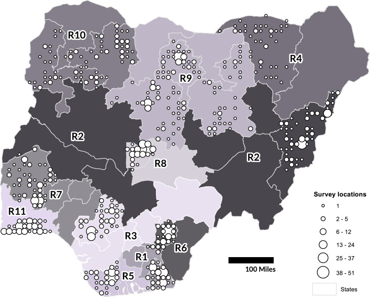
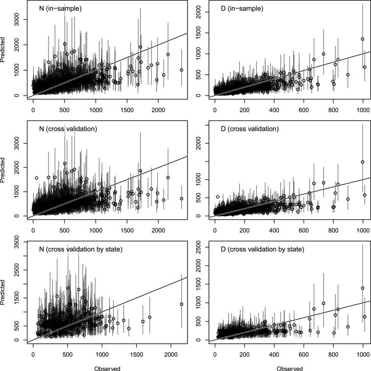
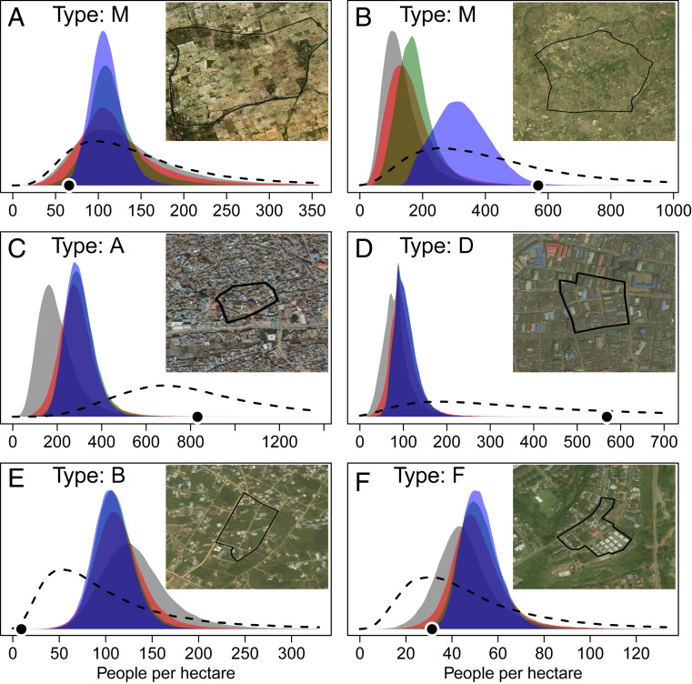
Population estimates are critical for government services, development projects, and public health campaigns. Such data are typically obtained through a national population and housing census. However, population estimates can quickly become inaccurate in localized areas, particularly where migration or displacement has occurred. Some conflict-affected and resource-poor countries have not conducted a census in over 10 y. We developed a hierarchical Bayesian model to estimate population numbers in small areas based on enumeration data from sample areas and nationwide information about administrative boundaries, building locations, settlement types, and other factors related to population density. We demonstrated this model by estimating population sizes in every 10- m grid cell in Nigeria with national coverage. These gridded population estimates and areal population totals derived from them are accompanied by estimates of uncertainty based on Bayesian posterior probabilities. The model had an overall error rate of 67 people per hectare (mean of absolute residuals) or 43% (using scaled residuals) for predictions in out-of-sample survey areas (approximately 3 ha each), with increased precision expected for aggregated population totals in larger areas. This statistical approach represents a significant step toward estimating populations at high resolution with national coverage in the absence of a complete and recent census, while also providing reliable estimates of uncertainty to support informed decision making.

摘要

人口估计对于政府服务、发展项目和公共卫生活动至关重要。此类数据通常通过全国人口和住房普查获得。然而,在局部地区,特别是在发生移民或流离失所的情况下,人口估计可能会迅速变得不准确。一些受冲突影响和资源匮乏的国家已经有 10 多年没有进行人口普查了。我们开发了一种分层贝叶斯模型,根据样本地区的普查数据以及关于行政边界、建筑物位置、定居类型和其他与人口密度相关的因素的全国信息,来估算小区域的人口数量。我们通过在全国范围内对尼日利亚的每个 10 米网格单元进行人口估算,展示了该模型。这些网格化的人口估计值及其衍生的面积人口总数都附有基于贝叶斯后验概率的不确定性估计值。对于样本外调查区域(每个区域约 3 公顷)的预测,该模型的总体误差率为每公顷 67 人(绝对残差的平均值)或 43%(使用比例残差),对于较大区域的聚合人口总数,预计会有更高的精度。在没有完整和最新的普查的情况下,这种统计方法代表了在全国范围内以高分辨率估算人口的重要一步,同时还提供了可靠的不确定性估计值,以支持明智的决策。

https://cdn.ncbi.nlm.nih.gov/pmc/blobs/8593/7533662/0e822a2f88ae/pnas.1913050117fig03.jpg
https://cdn.ncbi.nlm.nih.gov/pmc/blobs/8593/7533662/20b4b6ad85db/pnas.1913050117fig01.jpg
https://cdn.ncbi.nlm.nih.gov/pmc/blobs/8593/7533662/10e60a585a0e/pnas.1913050117fig02.jpg
https://cdn.ncbi.nlm.nih.gov/pmc/blobs/8593/7533662/0e822a2f88ae/pnas.1913050117fig03.jpg
https://cdn.ncbi.nlm.nih.gov/pmc/blobs/8593/7533662/20b4b6ad85db/pnas.1913050117fig01.jpg
https://cdn.ncbi.nlm.nih.gov/pmc/blobs/8593/7533662/10e60a585a0e/pnas.1913050117fig02.jpg
https://cdn.ncbi.nlm.nih.gov/pmc/blobs/8593/7533662/0e822a2f88ae/pnas.1913050117fig03.jpg

相似文献

1
National population mapping from sparse survey data: A hierarchical Bayesian modeling framework to account for uncertainty.从稀疏调查数据中进行全国人口制图:一个考虑不确定性的分层贝叶斯建模框架。
Proc Natl Acad Sci U S A. 2020 Sep 29;117(39):24173-24179. doi: 10.1073/pnas.1913050117. Epub 2020 Sep 14.
2
High-resolution population estimation using household survey data and building footprints.利用住户调查数据和建筑物轮廓进行高分辨率人口估计。
Nat Commun. 2022 Mar 14;13(1):1330. doi: 10.1038/s41467-022-29094-x.
3
Census-independent population mapping in northern Nigeria.尼日利亚北部的非人口普查式人口分布图绘制
Remote Sens Environ. 2018 Jan;204:786-798. doi: 10.1016/j.rse.2017.09.024.
4
Social cartography and satellite-derived building coverage for post-census population estimates in difficult-to-access regions of Colombia.社会制图和卫星衍生的建筑物覆盖范围用于哥伦比亚难以进入地区的人口普查后估计。
Popul Stud (Camb). 2024 Mar;78(1):3-20. doi: 10.1080/00324728.2023.2190151. Epub 2023 Mar 28.
5
Assessment and statistical modeling of the relationship between remotely sensed aerosol optical depth and PM2.5 in the eastern United States.美国东部地区遥感气溶胶光学厚度与PM2.5之间关系的评估及统计建模
Res Rep Health Eff Inst. 2012 May(167):5-83; discussion 85-91.
6
Part 2. Development of Enhanced Statistical Methods for Assessing Health Effects Associated with an Unknown Number of Major Sources of Multiple Air Pollutants.第2部分。开发增强的统计方法,以评估与多种空气污染物的未知数量主要来源相关的健康影响。
Res Rep Health Eff Inst. 2015 Jun(183 Pt 1-2):51-113.
7
The effects of spatial population dataset choice on estimates of population at risk of disease.空间人口数据集选择对疾病风险人口估计的影响。
Popul Health Metr. 2011 Feb 7;9:4. doi: 10.1186/1478-7954-9-4.
8
Estimating micro area behavioural risk factor prevalence from large population-based surveys: a full Bayesian approach.基于大规模人群调查估计微观区域行为风险因素患病率:一种全贝叶斯方法。
BMC Public Health. 2016 Jun 7;16:478. doi: 10.1186/s12889-016-3144-4.
9
Spatio-temporal analysis of misaligned burden of disease data using a geo-statistical approach.使用地理统计方法对疾病负担数据错位进行时空分析。
Stat Med. 2021 Feb 20;40(4):1021-1033. doi: 10.1002/sim.8817. Epub 2020 Dec 6.
10
Multimethod, multistate Bayesian hierarchical modeling approach for use in regional monitoring of wolves.用于狼的区域监测的多方法、多状态贝叶斯层次建模方法。
Conserv Biol. 2016 Aug;30(4):883-93. doi: 10.1111/cobi.12685. Epub 2016 May 4.

引用本文的文献

1
Tackling public health data gaps through Bayesian high-resolution population estimation: A case study of Kasaï-Oriental, Democratic Republic of the Congo.通过贝叶斯高分辨率人口估计解决公共卫生数据缺口:以刚果民主共和国东开赛省为例
PLOS Glob Public Health. 2025 Sep 4;5(9):e0005072. doi: 10.1371/journal.pgph.0005072. eCollection 2025.
2
Estimating small area population from health intervention campaign surveys and partially observed settlement data.根据健康干预活动调查和部分观测到的定居点数据估算小区域人口。
Nat Commun. 2025 May 28;16(1):4951. doi: 10.1038/s41467-025-59862-4.
3
Subnational variations in the quality of household survey data in sub-Saharan Africa.

本文引用的文献

1
Spatially disaggregated population estimates in the absence of national population and housing census data.在没有全国人口和住房普查数据的情况下进行空间分解的人口估计。
Proc Natl Acad Sci U S A. 2018 Apr 3;115(14):3529-3537. doi: 10.1073/pnas.1715305115. Epub 2018 Mar 19.
2
Census-independent population mapping in northern Nigeria.尼日利亚北部的非人口普查式人口分布图绘制
Remote Sens Environ. 2018 Jan;204:786-798. doi: 10.1016/j.rse.2017.09.024.
3
WorldPop, open data for spatial demography.世界人口数据,空间人口学的开放数据。
撒哈拉以南非洲地区家庭调查数据质量的次国家层面差异。
Nat Commun. 2025 Apr 22;16(1):3771. doi: 10.1038/s41467-025-58776-5.
4
Geospatial Variation in Vaccination Coverage and Zero-Dose Prevalence at the District, Ward and Health Facility Levels Before and After a Measles Vaccination Campaign in Nigeria.尼日利亚麻疹疫苗接种运动前后,地区、行政区和卫生设施层面的疫苗接种覆盖率及零剂量率的地理空间差异
Vaccines (Basel). 2024 Nov 21;12(12):1299. doi: 10.3390/vaccines12121299.
5
Improved Indicators for Subnational Unmet Antiretroviral Therapy Need in the Health System: Updates to the Naomi Model in 2023.2023 年卫生系统中未满足抗逆转录病毒治疗需求的国家级指标的改进:Naomi 模型更新。
J Acquir Immune Defic Syndr. 2024 Jan 1;95(1S):e24-e33. doi: 10.1097/QAI.0000000000003324. Epub 2024 Jan 4.
6
Geospatial Analyses of Recent Household Surveys to Assess Changes in the Distribution of Zero-Dose Children and Their Associated Factors before and during the COVID-19 Pandemic in Nigeria.利用近期家庭调查进行地理空间分析,以评估尼日利亚在2019冠状病毒病大流行之前及期间零剂量儿童分布的变化及其相关因素。
Vaccines (Basel). 2023 Dec 8;11(12):1830. doi: 10.3390/vaccines11121830.
7
Fine-grained population mapping from coarse census counts and open geodata.从粗略的人口普查计数和开放地理数据中进行细粒度的人口映射。
Sci Rep. 2022 Nov 22;12(1):20085. doi: 10.1038/s41598-022-24495-w.
8
High-resolution estimates of social distancing feasibility, mapped for urban areas in sub-Saharan Africa.高分辨率的社交距离可行性估计,为撒哈拉以南非洲的城市地区绘制。
Sci Data. 2022 Nov 18;9(1):711. doi: 10.1038/s41597-022-01799-0.
9
Small area population denominators for improved disease surveillance and response.小面积人口基数,提高疾病监测和应对能力。
Epidemics. 2022 Dec;41:100641. doi: 10.1016/j.epidem.2022.100641. Epub 2022 Oct 6.
10
Developing High-Resolution Population and Settlement Data for Impactful Malaria Interventions in Zambia.开发高分辨率人口和定居点数据,以在赞比亚实施有影响力的疟疾干预措施。
J Environ Public Health. 2022 Sep 27;2022:2941013. doi: 10.1155/2022/2941013. eCollection 2022.
Sci Data. 2017 Jan 31;4:170004. doi: 10.1038/sdata.2017.4.
4
Disaggregating census data for population mapping using random forests with remotely-sensed and ancillary data.使用随机森林结合遥感数据和辅助数据对人口普查数据进行分解以绘制人口地图。
PLoS One. 2015 Feb 17;10(2):e0107042. doi: 10.1371/journal.pone.0107042. eCollection 2015.
5
World population stabilization unlikely this century.本世纪世界人口不太可能稳定下来。
Science. 2014 Oct 10;346(6206):234-7. doi: 10.1126/science.1257469. Epub 2014 Sep 18.
6
Bayesian probabilistic population projections for all countries.贝叶斯概率人口预测:所有国家通用。
Proc Natl Acad Sci U S A. 2012 Aug 28;109(35):13915-21. doi: 10.1073/pnas.1211452109. Epub 2012 Aug 20.