• 文献检索
  • 文档翻译
  • 深度研究
  • 学术资讯
  • Suppr Zotero 插件Zotero 插件
  • 邀请有礼
  • 套餐&价格
  • 历史记录
应用&插件
Suppr Zotero 插件Zotero 插件浏览器插件Mac 客户端Windows 客户端微信小程序
定价
高级版会员购买积分包购买API积分包
服务
文献检索文档翻译深度研究API 文档MCP 服务
关于我们
关于 Suppr公司介绍联系我们用户协议隐私条款
关注我们

Suppr 超能文献

核心技术专利:CN118964589B侵权必究
粤ICP备2023148730 号-1Suppr @ 2026

文献检索

告别复杂PubMed语法,用中文像聊天一样搜索,搜遍4000万医学文献。AI智能推荐,让科研检索更轻松。

立即免费搜索

文件翻译

保留排版,准确专业,支持PDF/Word/PPT等文件格式,支持 12+语言互译。

免费翻译文档

深度研究

AI帮你快速写综述,25分钟生成高质量综述,智能提取关键信息,辅助科研写作。

立即免费体验

基于可信决策树的新型集成模型在沟蚀空间评估和可持续管理中的应用。

Credal decision tree based novel ensemble models for spatial assessment of gully erosion and sustainable management.

机构信息

Department of Geomorphology, Tarbiat Modares University, Jalal Ale Ahmad Highway, 9821, Tehran, Iran.

Faculty of Geo-Information Science and Earth Observation (ITC), University of Twente, Enschede, The Netherlands.

出版信息

Sci Rep. 2021 Feb 4;11(1):3147. doi: 10.1038/s41598-021-82527-3.

DOI:10.1038/s41598-021-82527-3
PMID:33542340
原文链接:https://pmc.ncbi.nlm.nih.gov/articles/PMC7862281/
Abstract

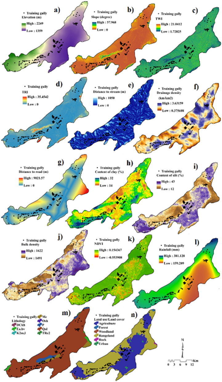
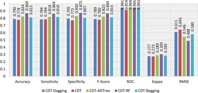
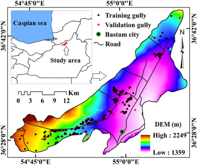
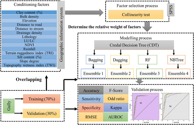
We introduce novel hybrid ensemble models in gully erosion susceptibility mapping (GESM) through a case study in the Bastam sedimentary plain of Northern Iran. Four new ensemble models including credal decision tree-bagging (CDT-BA), credal decision tree-dagging (CDT-DA), credal decision tree-rotation forest (CDT-RF), and credal decision tree-alternative decision tree (CDT-ADTree) are employed for mapping the gully erosion susceptibility (GES) with the help of 14 predictor factors and 293 gully locations. The relative significance of GECFs in modelling GES is assessed by random forest algorithm. Two cut-off-independent (area under success rate curve and area under predictor rate curve) and six cut-off-dependent metrics (accuracy, sensitivity, specificity, F-score, odd ratio and Cohen Kappa) were utilized based on both calibration as well as testing dataset. Drainage density, distance to road, rainfall and NDVI were found to be the most influencing predictor variables for GESM. The CDT-RF (AUSRC = 0.942, AUPRC = 0.945, accuracy = 0.869, specificity = 0.875, sensitivity = 0.864, RMSE = 0.488, F-score = 0.869 and Cohen's Kappa = 0.305) was found to be the most robust model which showcased outstanding predictive accuracy in mapping GES. Our study shows that the GESM can be utilized for conserving soil resources and for controlling future gully erosion.

摘要

我们通过伊朗北部巴斯坦沉积平原的案例研究,在沟蚀易感性制图(GESM)中引入了新的混合集成模型。在 14 个预测因子和 293 个沟壑位置的帮助下,采用了四种新的集成模型,包括可信决策树装袋(CDT-BA)、可信决策树装袋(CDT-DA)、可信决策树旋转森林(CDT-RF)和可信决策树替代决策树(CDT-ADTree),用于绘制沟壑侵蚀易感性(GES)。随机森林算法评估了 GECFs 在建模 GES 中的相对重要性。基于校准和测试数据集,使用了两个无截止值独立(成功率曲线下面积和预测率曲线下面积)和六个截止值依赖指标(准确性、灵敏度、特异性、F 分数、优势比和 Cohen Kappa)。排水密度、到道路的距离、降雨量和 NDVI 被发现是 GESM 最具影响力的预测变量。CDT-RF(AUSRC=0.942、AUPRC=0.945、准确性=0.869、特异性=0.875、灵敏度=0.864、RMSE=0.488、F 分数=0.869 和 Cohen 的 Kappa=0.305)被认为是最稳健的模型,在绘制 GES 方面表现出出色的预测精度。我们的研究表明,GESM 可用于保护土壤资源和控制未来的沟壑侵蚀。

https://cdn.ncbi.nlm.nih.gov/pmc/blobs/1bb0/7862281/49c58f852796/41598_2021_82527_Fig10_HTML.jpg
https://cdn.ncbi.nlm.nih.gov/pmc/blobs/1bb0/7862281/0854e51b04ac/41598_2021_82527_Fig1_HTML.jpg
https://cdn.ncbi.nlm.nih.gov/pmc/blobs/1bb0/7862281/44b93de0ba0f/41598_2021_82527_Fig2_HTML.jpg
https://cdn.ncbi.nlm.nih.gov/pmc/blobs/1bb0/7862281/1da17eba635e/41598_2021_82527_Fig3_HTML.jpg
https://cdn.ncbi.nlm.nih.gov/pmc/blobs/1bb0/7862281/39e832e6daaf/41598_2021_82527_Fig4_HTML.jpg
https://cdn.ncbi.nlm.nih.gov/pmc/blobs/1bb0/7862281/e8df9668f120/41598_2021_82527_Fig5_HTML.jpg
https://cdn.ncbi.nlm.nih.gov/pmc/blobs/1bb0/7862281/1efc5b3fa9ad/41598_2021_82527_Fig6_HTML.jpg
https://cdn.ncbi.nlm.nih.gov/pmc/blobs/1bb0/7862281/e0941fb7a636/41598_2021_82527_Fig7_HTML.jpg
https://cdn.ncbi.nlm.nih.gov/pmc/blobs/1bb0/7862281/c94f5c6874de/41598_2021_82527_Fig8_HTML.jpg
https://cdn.ncbi.nlm.nih.gov/pmc/blobs/1bb0/7862281/48444687ebff/41598_2021_82527_Fig9_HTML.jpg
https://cdn.ncbi.nlm.nih.gov/pmc/blobs/1bb0/7862281/49c58f852796/41598_2021_82527_Fig10_HTML.jpg

相似文献

1
Credal decision tree based novel ensemble models for spatial assessment of gully erosion and sustainable management.基于可信决策树的新型集成模型在沟蚀空间评估和可持续管理中的应用。
Sci Rep. 2021 Feb 4;11(1):3147. doi: 10.1038/s41598-021-82527-3.
2
Evaluation of Recent Advanced Soft Computing Techniques for Gully Erosion Susceptibility Mapping: A Comparative Study.评价近期先进的软计算技术在沟蚀易发性制图中的应用:一项比较研究。
Sensors (Basel). 2020 Jan 7;20(2):335. doi: 10.3390/s20020335.
3
Novel Entropy and Rotation Forest-Based Credal Decision Tree Classifier for Landslide Susceptibility Modeling.基于新型熵和旋转森林的证据决策树分类器用于滑坡易发性建模
Entropy (Basel). 2019 Jan 23;21(2):106. doi: 10.3390/e21020106.
4
Novel ensembles of COPRAS multi-criteria decision-making with logistic regression, boosted regression tree, and random forest for spatial prediction of gully erosion susceptibility.用于沟壑侵蚀敏感性空间预测的结合逻辑回归、提升回归树和随机森林的新型COPRAS多标准决策集成方法。
Sci Total Environ. 2019 Oct 20;688:903-916. doi: 10.1016/j.scitotenv.2019.06.205. Epub 2019 Jun 20.
5
Machine Learning-Based Gully Erosion Susceptibility Mapping: A Case Study of Eastern India.基于机器学习的沟壑侵蚀敏感性制图:以印度东部为例。
Sensors (Basel). 2020 Feb 28;20(5):1313. doi: 10.3390/s20051313.
6
A Novel Ensemble Artificial Intelligence Approach for Gully Erosion Mapping in a Semi-Arid Watershed (Iran).一种用于半干旱流域(伊朗)沟壑侵蚀制图的新型集成人工智能方法
Sensors (Basel). 2019 May 29;19(11):2444. doi: 10.3390/s19112444.
7
Assessing the performance of GIS- based machine learning models with different accuracy measures for determining susceptibility to gully erosion.评估基于 GIS 的机器学习模型的性能,使用不同的精度度量来确定沟蚀易感性。
Sci Total Environ. 2019 May 10;664:1117-1132. doi: 10.1016/j.scitotenv.2019.02.093. Epub 2019 Feb 6.
8
Evaluation of different boosting ensemble machine learning models and novel deep learning and boosting framework for head-cut gully erosion susceptibility.不同增强集成机器学习模型及新型深度学习和增强框架对头切沟蚀敏感性的评价。
J Environ Manage. 2021 Apr 15;284:112015. doi: 10.1016/j.jenvman.2021.112015. Epub 2021 Jan 28.
9
Gully erosion zonation mapping using integrated geographically weighted regression with certainty factor and random forest models in GIS.基于地理加权回归集成确定性因子和随机森林模型的沟壑侵蚀分区制图在地理信息系统中的应用
J Environ Manage. 2019 Feb 15;232:928-942. doi: 10.1016/j.jenvman.2018.11.110. Epub 2018 Dec 10.
10
Modelling gully-erosion susceptibility in a semi-arid region, Iran: Investigation of applicability of certainty factor and maximum entropy models.半干旱地区沟壑侵蚀敏感性建模:确定性因子和最大熵模型适用性研究。
Sci Total Environ. 2019 Mar 10;655:684-696. doi: 10.1016/j.scitotenv.2018.11.235. Epub 2018 Nov 17.

引用本文的文献

1
Application of smart technologies for predicting soil erosion patterns.智能技术在预测土壤侵蚀模式中的应用。
Sci Rep. 2025 Jul 21;15(1):26479. doi: 10.1038/s41598-025-12125-0.
2
Prediction of Soil Pollution Risk Based on Machine Learning and SHAP Interpretable Models in the Nansi Lake, China.基于机器学习和SHAP可解释模型的中国南四湖土壤污染风险预测
Toxics. 2025 Apr 5;13(4):278. doi: 10.3390/toxics13040278.
3
Assessing habitat selection parameters of Arabica coffee using BWM and BCM methods based on GIS.基于地理信息系统(GIS),运用最佳-最差法(BWM)和生物气候模型(BCM)评估阿拉比卡咖啡的栖息地选择参数。

本文引用的文献

1
Gully erosion zonation mapping using integrated geographically weighted regression with certainty factor and random forest models in GIS.基于地理加权回归集成确定性因子和随机森林模型的沟壑侵蚀分区制图在地理信息系统中的应用
J Environ Manage. 2019 Feb 15;232:928-942. doi: 10.1016/j.jenvman.2018.11.110. Epub 2018 Dec 10.
2
Evaluation of factors affecting gully headcut location using summary statistics and the maximum entropy model: Golestan Province, NE Iran.使用汇总统计和最大熵模型评估影响沟壑源头位置的因素:伊朗东北部戈勒斯坦省
Sci Total Environ. 2019 Aug 10;677:281-298. doi: 10.1016/j.scitotenv.2019.04.306. Epub 2019 Apr 26.
3
Sci Rep. 2025 Jan 2;15(1):8. doi: 10.1038/s41598-024-84073-0.
Land subsidence modelling using tree-based machine learning algorithms.
基于树的机器学习算法的地面沉降建模
Sci Total Environ. 2019 Jul 1;672:239-252. doi: 10.1016/j.scitotenv.2019.03.496. Epub 2019 Apr 2.
4
How can statistical and artificial intelligence approaches predict piping erosion susceptibility?统计和人工智能方法如何预测管道冲蚀敏感性?
Sci Total Environ. 2019 Jan 1;646:1554-1566. doi: 10.1016/j.scitotenv.2018.07.396. Epub 2018 Jul 29.
5
Rotation forest: A new classifier ensemble method.旋转森林:一种新的分类器集成方法。
IEEE Trans Pattern Anal Mach Intell. 2006 Oct;28(10):1619-30. doi: 10.1109/TPAMI.2006.211.