• 文献检索
  • 文档翻译
  • 深度研究
  • 学术资讯
  • Suppr Zotero 插件Zotero 插件
  • 邀请有礼
  • 套餐&价格
  • 历史记录
应用&插件
Suppr Zotero 插件Zotero 插件浏览器插件Mac 客户端Windows 客户端微信小程序
定价
高级版会员购买积分包购买API积分包
服务
文献检索文档翻译深度研究API 文档MCP 服务
关于我们
关于 Suppr公司介绍联系我们用户协议隐私条款
关注我们

Suppr 超能文献

核心技术专利:CN118964589B侵权必究
粤ICP备2023148730 号-1Suppr @ 2026

文献检索

告别复杂PubMed语法,用中文像聊天一样搜索,搜遍4000万医学文献。AI智能推荐,让科研检索更轻松。

立即免费搜索

文件翻译

保留排版,准确专业,支持PDF/Word/PPT等文件格式,支持 12+语言互译。

免费翻译文档

深度研究

AI帮你快速写综述,25分钟生成高质量综述,智能提取关键信息,辅助科研写作。

立即免费体验

新型高光谱卫星 PRISMA:用于森林类型判别成像。

The New Hyperspectral Satellite PRISMA: Imagery for Forest Types Discrimination.

机构信息

Dipartimento di Scienze e Tecnologie Agrarie, Alimentari, Ambientali e Forestali, Università degli Studi di Firenze, 50145 Firenze, Italy.

Dipartimento di Bioscienze e Territorio, Università degli Studi del Molise, 86100 Campobasso, Italy.

出版信息

Sensors (Basel). 2021 Feb 8;21(4):1182. doi: 10.3390/s21041182.

DOI:10.3390/s21041182
PMID:33567591
原文链接:https://pmc.ncbi.nlm.nih.gov/articles/PMC7915604/
Abstract

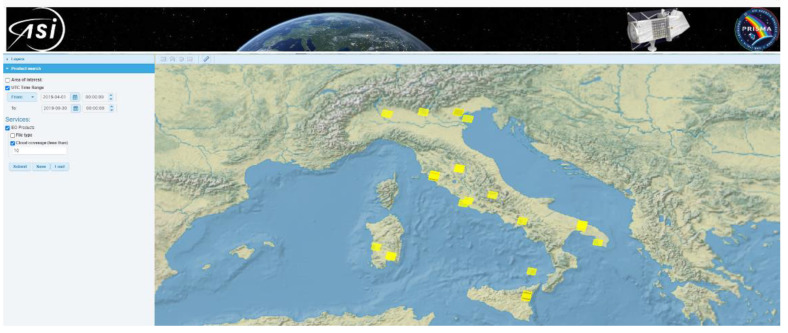
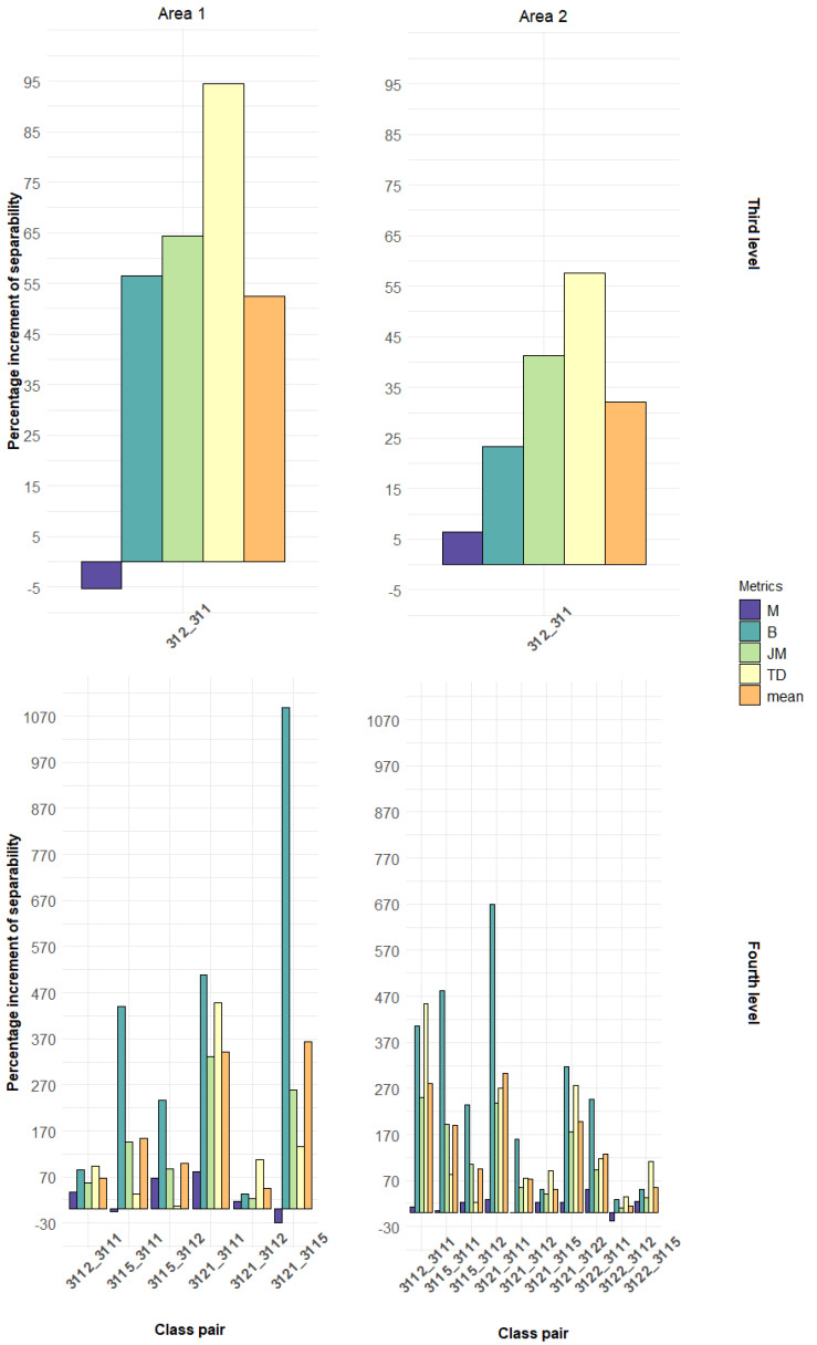
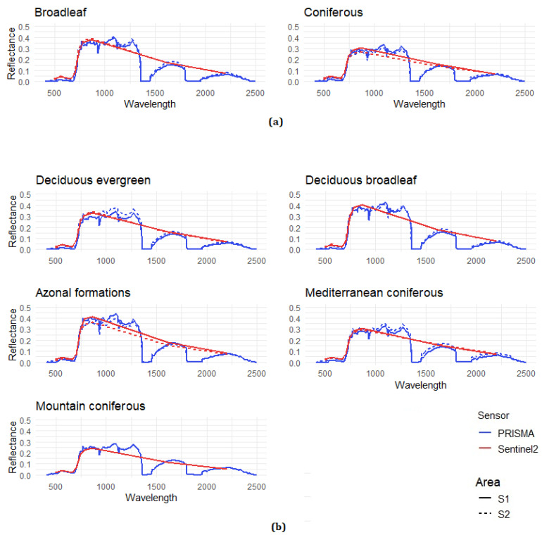
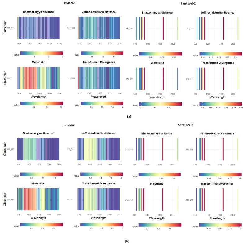
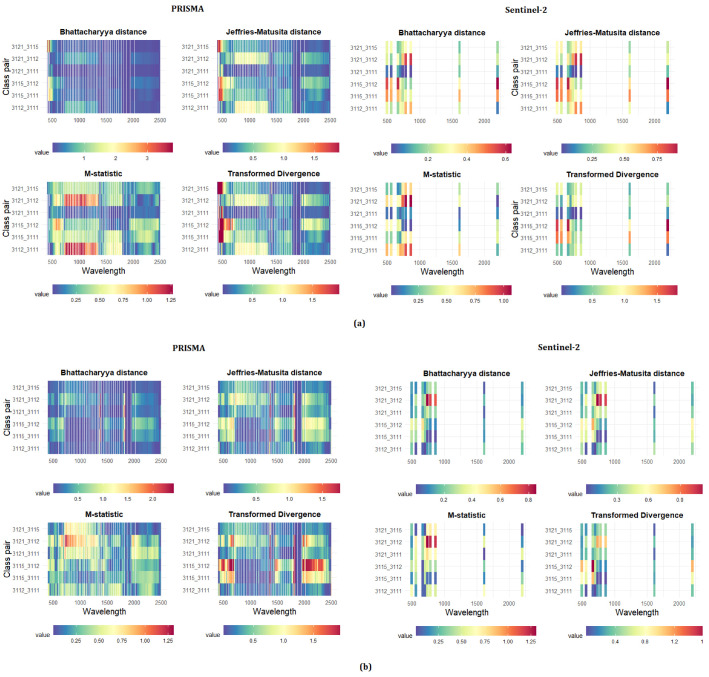
Different forest types based on different tree species composition may have similar spectral signatures if observed with traditional multispectral satellite sensors. Hyperspectral imagery, with a more continuous representation of their spectral behavior may instead be used for their classification. The new hyperspectral Precursore IperSpettrale della Missione Applicativa (PRISMA) sensor, developed by the Italian Space Agency, is able to capture images in a continuum of 240 spectral bands ranging between 400 and 2500 nm, with a spectral resolution smaller than 12 nm. The new sensor can be employed for a large number of remote sensing applications, including forest types discrimination. In this study, we compared the capabilities of the new PRISMA sensor against the well-known Sentinel-2 Multi-Spectral Instrument (MSI) in recognition of different forest types through a pairwise separability analysis carried out in two study areas in Italy, using two different nomenclature systems and four separability metrics. The PRISMA hyperspectral sensor, compared to Sentinel-2 MSI, allowed for a better discrimination in all forest types, increasing the performance when the complexity of the nomenclature system also increased. PRISMA achieved an average improvement of 40% for the discrimination between two forest categories (coniferous vs. broadleaves) and of 102% in the discrimination between five forest types based on main tree species groups.

摘要

如果使用传统的多光谱卫星传感器进行观测,不同树种组成的不同森林类型可能具有相似的光谱特征。而高光谱图像则可以更连续地表现其光谱特性,因此可以用于分类。意大利航天局开发的新型高光谱 Precursore IperSpettrale della Missione Applicativa(PRISMA)传感器能够在 400 到 2500nm 之间的 240 个连续光谱波段中捕获图像,光谱分辨率小于 12nm。该新型传感器可用于多种遥感应用,包括森林类型识别。本研究通过在意大利的两个研究区进行的两两可分离性分析,比较了新型 PRISMA 传感器与知名的 Sentinel-2 多光谱仪器(MSI)在识别不同森林类型方面的能力,使用了两种不同的命名系统和四种可分离性度量标准。与 Sentinel-2 MSI 相比,PRISMA 高光谱传感器能够更好地识别所有森林类型,并且在命名系统复杂性增加时,性能也有所提高。PRISMA 在两种森林类型(针叶林与阔叶林)之间的识别中平均提高了 40%,在基于主要树种组的五种森林类型之间的识别中提高了 102%。

https://cdn.ncbi.nlm.nih.gov/pmc/blobs/4f17/7915604/7ea1cfabf65e/sensors-21-01182-g007.jpg
https://cdn.ncbi.nlm.nih.gov/pmc/blobs/4f17/7915604/4edebe0f3d8e/sensors-21-01182-g001.jpg
https://cdn.ncbi.nlm.nih.gov/pmc/blobs/4f17/7915604/4b46120878e4/sensors-21-01182-g002.jpg
https://cdn.ncbi.nlm.nih.gov/pmc/blobs/4f17/7915604/d0c8e8082932/sensors-21-01182-g003.jpg
https://cdn.ncbi.nlm.nih.gov/pmc/blobs/4f17/7915604/11341e8720cc/sensors-21-01182-g004.jpg
https://cdn.ncbi.nlm.nih.gov/pmc/blobs/4f17/7915604/d5a2579febeb/sensors-21-01182-g005.jpg
https://cdn.ncbi.nlm.nih.gov/pmc/blobs/4f17/7915604/51b9d6e334fb/sensors-21-01182-g006.jpg
https://cdn.ncbi.nlm.nih.gov/pmc/blobs/4f17/7915604/7ea1cfabf65e/sensors-21-01182-g007.jpg

相似文献

1
The New Hyperspectral Satellite PRISMA: Imagery for Forest Types Discrimination.新型高光谱卫星 PRISMA:用于森林类型判别成像。
Sensors (Basel). 2021 Feb 8;21(4):1182. doi: 10.3390/s21041182.
2
Leonardo spaceborne infrared payloads for Earth observation: SLSTRs for Copernicus Sentinel 3 and PRISMA hyperspectral camera for PRISMA satellite.用于地球观测的莱昂纳多星载红外有效载荷:哥白尼哨兵3号的SLSTR以及PRISMA卫星的PRISMA高光谱相机。
Appl Opt. 2020 Aug 10;59(23):6888-6901. doi: 10.1364/AO.389485.
3
Hybrid retrieval of crop traits from multi-temporal PRISMA hyperspectral imagery.从多时态PRISMA高光谱影像中混合检索作物性状
ISPRS J Photogramm Remote Sens. 2022 May;187:362-377. doi: 10.1016/j.isprsjprs.2022.03.014. Epub 2022 Apr 1.
4
First Evaluation of PRISMA Level 1 Data for Water Applications.用于水应用的 PRISMA 水平 1 数据的首次评估。
Sensors (Basel). 2020 Aug 14;20(16):4553. doi: 10.3390/s20164553.
5
In-situ and airborne hyperspectral data for detecting agricultural activities in a dense forest landscape.用于检测茂密森林景观中农业活动的原位和航空高光谱数据。
Data Brief. 2023 Aug 20;50:109510. doi: 10.1016/j.dib.2023.109510. eCollection 2023 Oct.
6
Satellite hyperspectral imaging technology as a potential rapid pollution assessment tool for urban landfill sites: case study of Ghazipur and Okhla landfill sites in Delhi, India.卫星高光谱成像技术作为一种潜在的城市垃圾填埋场快速污染评估工具:以印度德里的加济布尔和奥赫拉垃圾填埋场为例。
Environ Sci Pollut Res Int. 2023 Nov;30(55):116742-116750. doi: 10.1007/s11356-022-22421-1. Epub 2022 Aug 18.
7
Multitemporal Mapping of Post-Fire Land Cover Using Multiplatform PRISMA Hyperspectral and Sentinel-UAV Multispectral Data: Insights from Case Studies in Portugal and Italy.基于多平台 PRISMA 高光谱和哨兵-UAV 多光谱数据的火灾后土地覆盖多时相制图:来自葡萄牙和意大利案例研究的见解。
Sensors (Basel). 2021 Jun 9;21(12):3982. doi: 10.3390/s21123982.
8
Potential of DESIS and PRISMA hyperspectral remote sensing data in rock classification and mineral identification:a case study for Banswara in Rajasthan, India.DESIS 和 PRISMA 高光谱遥感数据在岩石分类和矿物识别中的潜力:以印度拉贾斯坦邦班斯瓦拉为例的研究。
Environ Monit Assess. 2023 Apr 15;195(5):575. doi: 10.1007/s10661-023-11200-1.
9
New Spectral Index for Detecting Wheat Yellow Rust Using Sentinel-2 Multispectral Imagery.利用哨兵 - 2 多光谱影像检测小麦条锈病的新光谱指数
Sensors (Basel). 2018 Mar 15;18(3):868. doi: 10.3390/s18030868.
10
Understanding the temporal dimension of the red-edge spectral region for forest decline detection using high-resolution hyperspectral and Sentinel-2a imagery.利用高分辨率高光谱和哨兵 - 2a 影像理解用于森林衰退检测的红边光谱区域的时间维度。
ISPRS J Photogramm Remote Sens. 2018 Mar;137:134-148. doi: 10.1016/j.isprsjprs.2018.01.017.

引用本文的文献

1
Current and Near-Term Earth-Observing Environmental Satellites, Their Missions, Characteristics, Instruments, and Applications.当前及近期的地球观测环境卫星、其任务、特性、仪器及应用
Sensors (Basel). 2024 May 28;24(11):3488. doi: 10.3390/s24113488.
2
Optical Identification of Diabetic Retinopathy Using Hyperspectral Imaging.利用高光谱成像技术对糖尿病视网膜病变进行光学识别。
J Pers Med. 2023 Jun 1;13(6):939. doi: 10.3390/jpm13060939.
3
Classification of Skin Cancer Using Novel Hyperspectral Imaging Engineering via YOLOv5.通过YOLOv5使用新型高光谱成像技术对皮肤癌进行分类。

本文引用的文献

1
Correction of satellite imagery over mountainous terrain.山区地形卫星图像校正。
Appl Opt. 1998 Jun 20;37(18):4004-15. doi: 10.1364/ao.37.004004.
J Clin Med. 2023 Feb 1;12(3):1134. doi: 10.3390/jcm12031134.
4
The Weight of Hyperion and PRISMA Hyperspectral Sensor Characteristics on Image Capability to Retrieve Urban Surface Materials in the City of Venice.《土卫七的质量和 PRISMA 高光谱传感器特性对威尼斯城市中获取城市表面材料的图像能力的影响》。
Sensors (Basel). 2023 Jan 1;23(1):454. doi: 10.3390/s23010454.
5
Tree species composition mapping with dimension reduction and post-classification using very high-resolution hyperspectral imaging.利用超高分辨率高光谱成像进行降维和后分类的树种组成制图。
Sci Rep. 2022 Dec 3;12(1):20919. doi: 10.1038/s41598-022-25404-x.
6
Intelligent Identification of Early Esophageal Cancer by Band-Selective Hyperspectral Imaging.基于波段选择高光谱成像的早期食管癌智能识别
Cancers (Basel). 2022 Sep 1;14(17):4292. doi: 10.3390/cancers14174292.
7
Air Pollution Detection Using a Novel Snap-Shot Hyperspectral Imaging Technique.利用新型快照高光谱成像技术进行空气污染检测。
Sensors (Basel). 2022 Aug 19;22(16):6231. doi: 10.3390/s22166231.
8
A Transmission Efficiency Evaluation Method of Adaptive Coding Modulation for Ka-Band Data-Transmission of LEO EO Satellites.一种用于低轨光学卫星Ka频段数据传输的自适应编码调制传输效率评估方法
Sensors (Basel). 2022 Jul 20;22(14):5423. doi: 10.3390/s22145423.
9
Multitemporal Mapping of Post-Fire Land Cover Using Multiplatform PRISMA Hyperspectral and Sentinel-UAV Multispectral Data: Insights from Case Studies in Portugal and Italy.基于多平台 PRISMA 高光谱和哨兵-UAV 多光谱数据的火灾后土地覆盖多时相制图:来自葡萄牙和意大利案例研究的见解。
Sensors (Basel). 2021 Jun 9;21(12):3982. doi: 10.3390/s21123982.